Seyhan
| Author:Laxman Burdak, IFS (R) |


Seyhan River is the longest river of Cilicia and the longest of Turkey that flows into the Mediterranean Sea. It is mentioned as Sarus by Pliny[1].
Variants
Jat clans
Jat Gotras Namesake
- Saras = Sarus (Pliny.vi.3)
Course
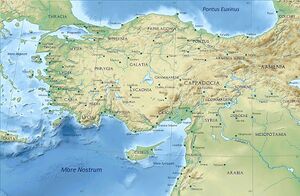
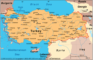
The river is 560 km and flows southwest from its headwaters in the Tahtalı-Mountains (in Sivas and Kayseri provinces) in the Anti-Taurus Mountains to the Mediterranean Sea via a broad delta. Its main tributaries are Zamantı and Göksu, which unite in Aladağ, Adana to form the Seyhan River. The Zamantı River originates from the Uzun Plateau in Pınarbaşı, Kayseri and crosses Tomarza, Develi and Yahyalı districts in Kayseri.
Its sources were reported being in the Taurus Mountains in Cataonia. It flowed through Cappadocia by the town of Comana, then through Cilicia. It is noted by numerous ancient authors including Livy,[3] Xenophon,[4] Procopius,[5] Strabo,[6] Ptolemy,[7] Appian,[8] Pliny the Elder,[9] and Eustathius of Thessalonica who erroneously calls it Sinarus.[10]
50 km from its mouth, Seyhan River flows through the city of Adana, the only settlement situated on the river. Several bridges and footbridges cross the river in Adana including the Stone Bridge, a 2nd-century Roman bridge. Ancient city of Augusta was also situated on the river, corresponding today to the east side of the Çatalan reservoir. The river meets the Mediterranean Sea at Cape Deli.
History
An ancient Greco-Roman legend mentions that the name of the city of Adana originates from Adanus, the son of the Greek god Uranus, who founded the city next to the river with his brother. His brother's name, Sarus, was given to the river.[11]
Originally, the River Sarus flowed from the mountains,[12] became the Seyhan River whilst passing through Cilicia and then onwards to the Mediterranean Sea.[13]
In 2009, a total of 33 fish species were listed as being found in the Seyhan River, including 29 native, 3 introduced and 4 endemic species. Eight amphibians were listed and two of them (Rana holtzi and Triturus vittatus cilicensis) are known to be endemic to the river.[14]
The major Seyhan Dam upstream of Adana serves for irrigation, hydroelectric power, and flood control. Yedigöze, Çatalan and Kavşak Bendi are the other dams on Seyhan River which also serve the same purposes. The river is currently under extensive development for hydroelectric power and irrigation.[15]
Mention by Pliny
Pliny[16] mentions...Cappadocia1 has in the interior Archelais,2 a colony founded by Claudius Cæsar, and past which the river Halys flows; also the towns of Comana,3 watered by the Sarus, Neocæsarea,4 by the Lycus,5 and Amasia,6 in the region of Gazacene, washed by the Iris. In Colopene it has Sebastia and Sebastopolis;7 these are insignificant places, but still equal in importance to those just mentioned.
1 The boundaries of Cappadocia varied under the dominion of the Persians, after the Macedonian conquest, and as a Roman province under the emperors.
2 Founded by Archelaüs, the last king of Cappadocia. In Hamilton's Researches, the site has been assumed to be the modern Ak-serai, but that place is not on the river Halys, as Leake supposes. It is, however, considered that Ak-serai agrees very well with the position of Archelais as laid down in the Itineraries, and that Pliny may have been misled in supposing that the stream on which it stood was the Halys.
3 Also called by the name of Chryse, or "Golden," to distinguish it from another place of the same name in Pontus. It is generally supposed that the town of Al-Bostan, on the Sihoon or Sarus, is on or near the site of this Comana.
4 Now called Niksar, according to D'Anville, though Hardouin says that it is Tocat. Parisot remarks, that this place belonged rather to Pontus than to Cappadocia.
5 A small tributary of the Iris, or Yeshil-Irmak, mentioned in the next Chapter.
6 Both to the west of Neo-Cæsarea. According to Tavernier, as quoted by Hardouin, the modern name of Sebastia is Sivas.
7 Still called Amasia, or Amasiyeh, and situate on the river Iris, or Yeshil Ermak. It was at one time the residence of the princes of Pontus, and the birth-place of the geographer Strabo. The remains of antiquity here are very considerable, and extremely interesting.
References
- ↑ Natural History by Pliny Book VI/Chapter 3
- ↑ John Garstang and O.R. Gurney The Geography of the Hittite Empire (1959), p. 51
- ↑ Livy. Ab Urbe Condita Libri [History of Rome]. Vol. 33.41.
- ↑ Xenophon, Anabasis 1.4.1.
- ↑ Procopius, de Aedif. 5.4.
- ↑ Strabo. Geographica. Vol. xii. p. 535. Page numbers refer to those of Isaac Casaubon's edition
- ↑ Ptolemy. The Geography. Vol. 5.8.4.
- ↑ Appian Syr. 4.
- ↑ Pliny. Naturalis Historia. Vol. 6.3.
- ↑ Eustathius of Thessalonica, ad Dion. Per. 867.
- ↑ Anton, Charles (1841). Classical Dictionary: Containing an account of the principal proper names mentioned in ancient authors... New York: Harper & Brothers
- ↑ Charles Pye A New Dictionary of Ancient Geography, exhibiting the modern in addition to the Ancient Names of places (1803), p. 299, at Google Books
- ↑ John Garstang and O.R. Gurney The Geography of the Hittite Empire (1959), p. 51, at Google Books
- ↑ Akbulut, Nuray; Bayarı, Serdar; Akbulut, Aydin; Şahin, Yalçın (2009). Rivers of Europe. pp. 643–672. ISBN 9780081026120.
- ↑ "Cumulative Impact Assessment Baseline Monitoring Report for the Goksu-Seyhan Hydropower Cascade" (PDF). EnerjiSA. February 2011.
- ↑ Natural History by Pliny Book VI/Chapter 3
Back to Rivers

