Kızılırmak
| Author:Laxman Burdak, IFS (R) |


Kızılırmak, once known as the Halys River (Ancient Greek: Ἅλυς) and Alis River (Armenian: Ալիս), is the longest river flowing entirely within Turkey.
Variants
- Alis River (Armenian: Ալիս)
- Halys (Pliny.vi.2, Pliny.vi.3)
- Halys River (later renamed the Kızılırmak River
- Kızılırmak River - Turkish pronunciation: [kɯzɯlɯrmak]
- Maraššantiya
- Red River
Jat clans
- Hali = Kızılırmak River = Halys River (Pliny.vi.2, Pliny.vi.3)
- Kajli = Kızılırmak River = Halys River (Pliny.vi.2, Pliny.vi.3)
Geography
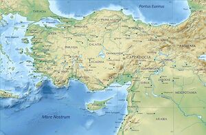
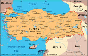
The Kızılırmak flows for a total of 1,355 kilometres,[1] rising in Eastern Anatolia around 39.8°N 38.3°E, flowing first to the west and southwest until 38.7°N 34.8°E, then forming a wide arch, the "Halys bend", flowing first to the west, then to the northwest, passing to the northeast of Lake Tuz (Tuz Gölü in Turkish), then to the north and northeast, where it is joined by its major tributary, the Delice River (once known in Greek as the Cappadox river) at 40.47°N 34.14°E. After zigzagging to the northwest to the confluence with the Devrez River at 41.10°N 34.42°E, and back to the northeast, it joins the Gökırmak (Blue River in Turkish) before finally flowing via a wide delta into the Black Sea east of Samsun at 41.72°N 35.95°E.
There are dams on the river at Boyabat, Altınkaya and Derbent.
History
The Hittites called the river the Maraššantiya, and it formed the western boundary of Hatti, the core land of the Hittite empire.
Until the Roman conquest of Anatolia the Halys River (later renamed the Kızılırmak by the Turkish conquerors) served as a natural political boundary in central Asia Minor, first between the kingdom of Lydia and the Persian Empire, and later between the Pontic Kingdom and the Kingdom of Cappadocia. As the site of the Battle of Halys, or the Battle of the Eclipse, on May 28, 585 BC,[2] the river formed the border between Lydia to the west and Media to the east until Croesus of Lydia crossed it to attack Cyrus the Great in 547 BC. He was defeated and Persia expanded to the Aegean Sea.
In the 1st century AD Vespasian combined several provinces, including Cappadocia, to create one large province with its eastern boundary marked by the Euphrates River. This province once again splintered during Trajan's reign - the newly created province of Cappadocia, bounded by the Euphrates to the East, included Pontus and Lesser Armenia. The Halys River became an interior river and never regained its significance as a political border. In the 130s a governor of Cappadocia wrote: "long ago the Halys River was the boundary between the kingdom of Croesus and the Persian Empire; now it flows under Roman dominion."[3]
Agriculture
The river's water is used to grow rice and in a few areas water buffalo are kept.
In popular culture
The historical fiction manga Red River is named after and largely set in the Kızılırmak basin, during the age of the Hittites
Mention by Pliny
Pliny[4] mentions...Cappadocia1 has in the interior Archelais,2 a colony founded by Claudius Cæsar, and past which the river Halys flows; also the towns of Comana,3 watered by the Sarus, Neocæsarea,4 by the Lycus,5 and Amasia,6 in the region of Gazacene, washed by the Iris. In Colopene it has Sebastia and Sebastopolis;7 these are insignificant places, but still equal in importance to those just mentioned.
1 The boundaries of Cappadocia varied under the dominion of the Persians, after the Macedonian conquest, and as a Roman province under the emperors.
2 Founded by Archelaüs, the last king of Cappadocia. In Hamilton's Researches, the site has been assumed to be the modern Ak-serai, but that place is not on the river Halys, as Leake supposes. It is, however, considered that Ak-serai agrees very well with the position of Archelais as laid down in the Itineraries, and that Pliny may have been misled in supposing that the stream on which it stood was the Halys.
3 Also called by the name of Chryse, or "Golden," to distinguish it from another place of the same name in Pontus. It is generally supposed that the town of Al-Bostan, on the Sihoon or Sarus, is on or near the site of this Comana.
4 Now called Niksar, according to D'Anville, though Hardouin says that it is Tocat. Parisot remarks, that this place belonged rather to Pontus than to Cappadocia.
5 A small tributary of the Iris, or Yeshil-Irmak, mentioned in the next Chapter.
6 Both to the west of Neo-Cæsarea. According to Tavernier, as quoted by Hardouin, the modern name of Sebastia is Sivas.
7 Still called Amasia, or Amasiyeh, and situate on the river Iris, or Yeshil Ermak. It was at one time the residence of the princes of Pontus, and the birth-place of the geographer Strabo. The remains of antiquity here are very considerable, and extremely interesting.
Mention by Pliny
Pliny[5] mentions...We then come to the river Evarchus13, and after that a people of the Cappadocians, the towns of Gaziura14 and Gazelum15, the river Halys16, which runs from the foot of Mount Taurus through Cataonia and Cappadocia, the towns of Gangre17 and Carusa18, the free town of Amisus19, distant from Sinope one hundred and thirty miles, and a gulf of the same name, of such vast extent20 as to make Asia assume the form of a peninsula, the isthmus of which is only some two hundred21 miles in breadth, or a little more, across to the gulf of Issus in Cilicia. In all this district there are, it is said, only three races that can rightly be termed Greeks, the Dorians, the Ionians, and the Æolians, all the rest being of barbarian origin.22 To Amisus was joined the town of Eupatoria23, founded by Mithridates: after his defeat they were both included under the name of Pompeiopolis.
14 On the river Iris. It was the ancient residence of the kings of Pontus, but in Strabo's time it was deserted. It has been suggested that the modern Azurnis occupies its site.
15 In the north-west of Pontus, in a fertile plain between the rivers Halys and Amisus. It is also called Gadilon by Strabo. D'Anville makes it the modern Aladgiam; while he calls Gaziura by the name of Guedes.
16 Now called the Kisil Irmak, or Red River. It has been remarked that Pliny, in making this river to come down from Mount Taurus and flow at once from south to north, appears to confound the Halys with one of its tributaries, now known as the Izchel Irmak.
17 Its site is now called Kiengareh, Kangreh, or Changeri. This was a town of Paphlagonia, to the south of Mount Olgasys, at a distance of thirty-five miles from Pompeiopolis.
18 A commercial place to the south of Sinope. Its site is the modern Gherseh on the coast.
19 Now called Eski Samsun; on the west side of the bay or gulf, anciently called Sinus Amisenus. According to Strabo, it was only 900 stadia from Sinope, or 112 1/2 Roman miles. The walls of the ancient city are to be seen on a promontory about a mile and a half from the modern town.
20 He means the numerous indentations which run southward into the coast, from the headland of Sinope to a distance of about one degree to the south.
21 On examining the map, we shall find that the distance is at least 300 miles across to the gulf of Issus or Iskenderoon.
22 Not speaking the Greek language.
23 A part of it only was added to Eupatoria; and it was separated from the rest by a wall, and probably contained a different population from that of Amisus. This new quarter contained the residence of the king, Mithridates Eupator, who built Eupatoria.
References
- ↑ Turkish Statistical Institute (2011). "Land and Climate". Turkey in Statistics 2011: The Summary of Turkey's Statistical Yearbook, 2011. p. 2.
- ↑ Historically it was known as the Battle of Halys; it has since been renamed by some as the Battle of the Eclipse, as the first premodern battle which can be dated with certainty due to the eclipse which brought about its sudden end.
- ↑ Dam, Raymond Van (2002-08-30). Kingdom of Snow: Roman Rule and Greek Culture in Cappadocia. University of Pennsylvania Press. ISBN 978-0-8122-3681-1.
- ↑ Natural History by Pliny Book VI/Chapter 3
- ↑ Natural History by Pliny Book VI/Chapter 2
Back to Rivers/ Back to Jat Places in Turkey

