Carusa
| Author:Laxman Burdak, IFS (R) |

Carusa was a Greek trading place (emporium) in Turkey. Carusa is mentioned by Pliny. [1]Carusa is located near Gerze in Asiatic Turkey.[2][3] Karushas (करूष) were ancient people and Janapada known to Panini and mentioned in Mahabharata/Ramayana. They fought Mahabharata War in Pandava's side
Variants
- Carusa (Pliny.vi.2)
- Karusa
- Karoussa (Ancient Greek: Κάρουσσα)
- Carussa
- Karousa (Καροῦσα)
- Polichnion,[4]
- Karushas (people)
- Gerze or Gherseh - Modern site of ancient Carusa
Karusha people of Mahabharata
Karusha (करूष) were ancient people and Janapada known to Panini and mentioned in Mahabharata/Ramayana. They fought Mahabharata War in Pandava's side. For details see Karusha.
Jat clans
Location
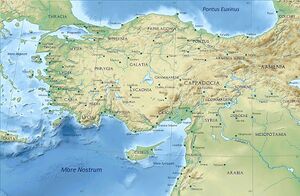
Karusa is located in Turkey on the Black Sea coast of ancient Paphlagonia, south of Sinope, and 150 stadia from it .[5][6]
Carusa is located near Gerze in Asiatic Turkey.[7][8]
Gerze town
Gerze is a town and a district of Sinop Province in the Black Sea region of Turkey. It is 49 km east of Sinop and 140 km west of Samsun. It was first settled by the Ionians and was known as Carusa.
History
It is also mentioned in the Periplus of Pseudo-Scylax as a Greek city; and by Pliny the Elder.[9] It was a member of the Delian League as it appears in tribute lists of ancient Athens.[10]
Tej Ram Sharma[11] mentions about people named Karusas.... The ancient kingdom of Kasi was bounded by Kosala on the north, Magadha on the east, and Vatsa on the west. The Chedis and Karusas lived to their south. [12] At the time of Buddha, the kingdom of Kasi was absorbed by the kingdom of Kosala. Geographical Dictionary of Ancient and Medieval India by N. L. Dey, p, 95.
Sandhya Jain[13] mentions Karushas among Mahabharata Tribes listed on Pandava Side: 3. Karusha (करूष) - A very ancient tribe and prominent ally of Pandavas; possibly hailed from the south of Kashi. See Mahabharata (VI.10.39).[14]....The Mahabharata Tribe - Karusha (करूष) may be identified with Jat Gotra - Karesia (करेसिया) who live in Chittorgarh and Tonk districts in Rajasthan.
In Mahabharata
Karusha (करूष) is mentioned in Mahabharata (I.70.13), (II.13.10), (II.13.12), (VI.10.39),(VI.52.13), (VI.112.73), (VII.13.15-18), (VIII.51.6), (XIII.116.67),
Mention by Pliny
Pliny[15] mentions...We then come to the river Evarchus13, and after that a people of the Cappadocians, the towns of Gaziura14 and Gazelum15, the river Halys16, which runs from the foot of Mount Taurus through Cataonia and Cappadocia, the towns of Gangre17 and Carusa18, the free town of Amisus19, distant from Sinope one hundred and thirty miles, and a gulf of the same name....
13 The boundary, according to Stephanus Byzantinus, also of the nations of Paphlagonia and Cappadocia. As Parisot remarks, this is an error, arising from the circumstance of a small tribe bearing the name of Cappadocians, having settled on its banks, between whom and the Paphlagonians it served as a limit.
14 On the river Iris. It was the ancient residence of the kings of Pontus, but in Strabo's time it was deserted. It has been suggested that the modern Azurnis occupies its site.
15 In the north-west of Pontus, in a fertile plain between the rivers Halys and Amisus. It is also called Gadilon by Strabo. D'Anville makes it the modern Aladgiam; while he calls Gaziura by the name of Guedes.
16 Now called the Kisil Irmak, or Red River. It has been remarked that Pliny, in making this river to come down from Mount Taurus and flow at once from south to north, appears to confound the Halys with one of its tributaries, now known as the Izchel Irmak.
17 Its site is now called Kiengareh, Kangreh, or Changeri. This was a town of Paphlagonia, to the south of Mount Olgasys, at a distance of thirty-five miles from Pompeiopolis.
18 A commercial place to the south of Sinope. Its site is the modern Gherseh on the coast.
19 Now called Eski Samsun; on the west side of the bay or gulf, anciently called Sinus Amisenus. According to Strabo, it was only 900 stadia from Sinope, or 112 1/2 Roman miles. The walls of the ancient city are to be seen on a promontory about a mile and a half from the modern town.
See also
References
- ↑ Pliny.vi.2
- ↑ Richard Talbert, ed. (2000). Barrington Atlas of the Greek and Roman World. Princeton University Press. p. 87, and directory notes accompanying.
- ↑ Lund University. Digital Atlas of the Roman Empire.
- ↑ Richard Talbert, ed. (2000). Barrington Atlas of the Greek and Roman World. Princeton University Press. p. 87, and directory notes accompanying.
- ↑ Arrian. Periplus Ponti Euxini. Vol. p. 15.
- ↑ Marcian of Heraclea, p. 73.
- ↑ Richard Talbert, ed. (2000). Barrington Atlas of the Greek and Roman World. Princeton University Press. p. 87, and directory notes accompanying.
- ↑ Lund University. Digital Atlas of the Roman Empire.
- ↑ Pliny. Naturalis Historia. Vol. 6.2.
- ↑ Mogens Herman Hansen & Thomas Heine Nielsen (2004). An inventory of archaic and classical poleis. New York: Oxford University Press. p. 958. ISBN 0-19-814099-1.
- ↑ Personal and geographical names in the Gupta inscriptions/Place-Names and their Suffixes,p.257
- ↑ Ethnic Settlements in Ancient India by S. B. Chaudhuri. p. 60.
- ↑ Sandhya Jain: Adi Deo Arya Devata - A Panoramic View of Tribal-Hindu Cultural Interface, Rupa & Co, 7/16, Ansari Road Daryaganj, New Delhi, 2004,p.116
- ↑ चेदिवत्साः करूषाश च भॊजाः सिन्धुपुलिन्थकाः । उत्तमौजा दशार्णाश च मेकलाश चॊत्कलैः सह (VI.10.39)
- ↑ Natural History by Pliny Book VI/Chapter 2
Back to Jat Places in Turkey/Back to Jat Places in Anatolia

