Sittacene
| Author:Laxman Burdak, IFS (R) |

Sittacene was an ancient region of Babylonia and Assyria situated about the main city of Sittace.
Variants
- Sitacenians (Anabasis by Arrian,p. 156, 161.)
- Sittacene (region)
- Sittace (city)
- Apolloniatis (Strabo xi. p. 524)
- Satrapene (Curtius v. 2)
- Sitacene
Jat Gotras Namesake
Jat Gotras Namesake
- Sitarwar = Sitacenians (Anabasis by Arrian,p. 156, 161.)
- Sithel = Sitacenians (Anabasis by Arrian,p. 156, 161.)
History
Pliny in his Natural History, Book 6, §§ 205-206, places Sittacene between Chalonitis, Persis and Mesene and also between Arbelitis and Palestine (or that it also bore those names, id., vi. 27. s. 31). Besides Sittace, Sabata, and Antiochia are identified as important cities. The district of Sittacene appears to have been called in later times Apolloniatis (Strabo xi. p. 524), and which adjoined the province of Susis (xv. p. 732). It is probably the same country which Curtius calls Satrapene (v. 2).
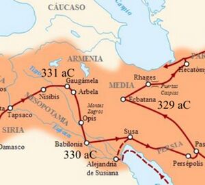
Alexander the Great's forces marched through Sittacene on their way from Babylon to Susa. Curtius and Diodorus place Alexander's major reorganization of his forces between their reinforcement at Babylon and the campaign against Susa in Sittacene. (Curt. v. 1. 40-42, v. 2. 1–7; Diod. xvii. 65)[1] A depiction of the games which were held to boost morale became the subject of a famous painting in the collection of the Getty Museum.[2]
When Alexander the Great visited the region, he found a settlement of Greek Boeotians established there since the time of Xerxes' campaign against Greece. (Diod. 17, 110, 4-5).
Mention by Pliny
Pliny[3] mentions The Parthian Empire....It is requisite in this place to trace the localities of the Medi also, and to describe in succession the features of the country as far as the Persian Sea, in order that the account which follows may be the better understood. Media8 lies crosswise to the west, and so presenting itself obliquely to Parthia, closes the entrance of both kingdoms9 into which it is divided.
It has, then, on the east, the Caspii and the Parthi; on the south, Sittacene, Susiane, and Persis; on the west, Adsiabene; and on the north, Armenia.
8 Media occupied the extreme west of the great table-land of the modern Iran. It corresponded very nearly to the modern province of Irak-Ajemi.
9 The Upper and the Lower, as already mentioned.
Mention by Pliny
Pliny[4] mentions Tigris....Between these peoples and Mesene is Sittacene, which is also called Arbelitis24 and Palæstine. Its city of Sittace25 is of Greek origin; this and Sabdata26 lie to the east, and on the west is Antiochia27, between the two rivers Tigris and Tornadotus28, as also Apamea29, to which Antiochus30 gave this name, being that of his mother. The Tigris surrounds this city, which is also traversed by the waters of the Archoüs.
24 From Arbela, in Assyria, which bordered on it.
25 A great and populous city of Babylonia, near the Tigris, but not on it, and eight parasangs within the Median wall. The site is that probably now called Eski Baghdad, and marked by a ruin called the Tower of Nimrod. Parisot cautions against confounding it with a place of a similar name, mentioned by Pliny in B. xii. c. 17, a mistake into which, he says, Hardouin has fallen.
26 Now called Felongia, according to Parisot. Hardouin considers it the same as the Sambana of Diodorus Siculus, which Parisot looks upon as the same as Ambar, to the north of Felongia.
27 Of this Antiochia nothing appears to be known. By some it has been supposed to be the same with Apollonia, the chief town of the district of Apolloniatis, to the south of the district of Arbela.
28 Also called the Physcus, the modern Ordoneh, an eastern tributary of the Tigris in Lower Assyria. The town of Opis stood at its junction with the Tigris.
29 D'Anville supposes that this Apamea was at the point where the Dijeil, now dry, branched off from the Tigris, which bifurcation he places near Samurrah. Lynch, however, has shown that the Dijeil branched off near Jibbarah, a little north of 34° North lat., and thinks that the Dijeil once swept the end of the Median wall, and flowed between it and Jebbarah. Possibly this is the Apamea mentioned by Pliny in c. 27.
30 The son of Seleucus Nicator.
In Parthian Stations
Parthian Stations by Isidore of Charax[5], is an account of the overland trade route between the Levant and India, in the 1st century BCE. .....2. From that place begins Apolloniatis, which extends 33 schoeni. It has villages, in which there are stations; and a Greek city, Artemita (Chalasar); through the midst of which flows the river Silla (the modern Diala). To that place from Seleucia is 15 schoeni. But now the city is called Chalasar.
References
- ↑ Arrian places these at Susa (iii. 16. 10)
- ↑ Arrian places these at Susa (iii. 16. 10)
- ↑ Natural History by Pliny Book VI/Chapter 29
- ↑ Natural History by Pliny Book VI/Chapter 31
- ↑ Parthian stations
Back to Jat Places in Assyria

