Seria
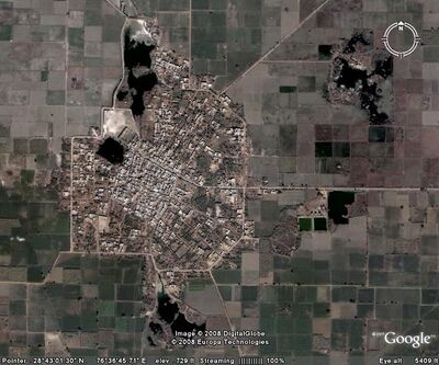
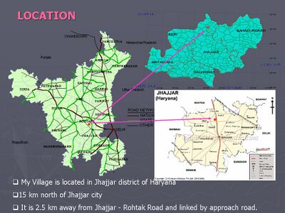
Seria (सेरिया) Village is situated in District Jhajjar (Haryana) at a Distance of 14 km from Jhajjar city and 28 km from Rohtak city. It falls 2 km inside from the NH -76 i.e. Rewari - Rohtak. The Village has good connectivity with all weather roads. Presently the village is selected for Modal Village Development Programme.
Gotras
Origin of the name
Initially, Ahlawats moved to Seria village and cleared the forests of this place for cultivation. Eldest of the brothers 'Shera' settled in the village after whom village got named Seria.
History
Ram Sarup Joon [1] writes that ... Ahlawat and Joon gotras belong to that branch of Solanki which ruled over Kaliani and Watapi (Vatapi) in South India from 5th to 12th century AD. They had a staunch enemy i.e. Raja Rajendra Chol. He attacked them with an army of one hundred thousand strong during the reign of seventh Raja Satish Raj Solanki and seized a major part of the kingdom.
In 1052 AD a new ruler of this dynasty came forth to redeem the old loss. His name was Ahumal and was titles Sameshwar I and Raj Raja. He attacked the Chol kingdom with a large army, conquered it and married Umang Devi daughter of the Chol king. He made Bangi his new capital. This kingdom existed astride the Tunga Bhadra River. Ahumal died in 1068 AD. His dynasty is called Ahlawat.
History of the Jats, End of Page-69
After several generations Bisaldev of this dynasty migrated towards north and settled down in village Nanhakhera (Seria) near Dighal in district Rohtak. He had four sons Olha, Ahlawat, Birmhan and Pehlawat An ancient pond (Birmala) named after Birmhan (Brebhan) is still famous for its sanctity in village Seria (Rohtak). Four new gotras (clans) originated after their names and are found settled in 30 villages around Dighal. Todd and Tarikhe Gujran have recorded this event in "Gazetteer of Rohtak" by Abdul Malik.
Seria (सेरिया) known as the "Dada-gaam" of Ahlawat Gotra and established by Dada Shera. Dada Shera were 4 brothers and he is the eldest one in all. The Village was established 1100 years back when some of the families from Dadrela (Jaisalmer – Rajasthan) came here by following the path of Gadkot(Sambhar Lake) to Kala Bad Aala (Bhiwani – Rajasthan) to Seria. They all came from the "Dadrela" village in "Jangladesh" near Sambhar Lake near Tonk District of Rajasthan.... First Established there habitation near "Kala Bad Aala" near Bhiwani City. 7 brother established the initial settlement near a Jal tree which is still exists there, 1 km outside present settlement.
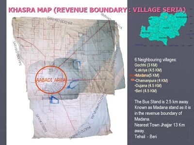
They got the location of water body following a muddy buffalo. The nearest settlement was Madana Village(Jhajjar District), 5 km away from present settlement (Haryana). Had a small fight with them who came to dislocate them. After the flood occurred and the site was low lying then migrated to the near by upper land where the actual Seria is....... later on they fragmented to four Village "Seria", "Gochhi", "Deeghal" and "Barhaana" later on three village fragmented from Deeghal too "Dhandhlaan", "Lakria" and "Gangtaan". These villages still have a respectable eye towards village Seria. The other cast people came later.
Fight for Settlement: Earlier when Dada Shera with his brother tried to establish themselves. One of the representative of Madana Village came to tell them to move somewhere else. Dada Shera told all the people came with him that if the person who has come to meet, will sit on the lower-side (Paint) of the cot than we will stay here of if he will sit on the upper-side (Sirhana) then we will move from here. The person came and sit on the lower-side of the cot. Dada Shera told that no one has power to remove them from the existing location. Some people from Madam came to fight with them to remove them from the location but got defeated and after that no fight took place.
Once people of Beri planned a robbery in Seria but their plans leaked out by a "Charaj Cast" people and Seria villagers got time to prepare themselves and the same thing was conveyed to Beri people also that Seria is ready for fight. People of Seria awarded that Charaj family with one hectare of land at a good location.
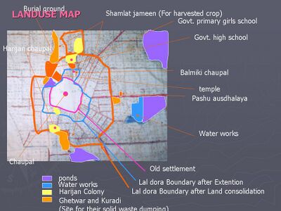
Durwasa Rishi Ashram ('kuti') was there at that time, at the location of present settlement. It was on the Sherkyar pond backside of the Govt. High School. Now no older structures are present of that time. It was a very high ground just near the Pond Sherkyar, where people say that Durwasa Rishi was living. At this point of time the pond is inside the village and it is a 2nd deepest pond among the other ponds and becomes a threat for the structures around it. Also it has engulfed the three wells, which were on its banks. The elder brother Shera with two of his brothers established the first settlement there, on the high land.
The village of one Micro-Habitat has now grown up-to 45 Micro- Habitat.
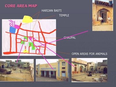
Occupation and Infrastructure
Most of the people of the village work on agricultural activities . All the streets of the Village are pukka Streets (All weather). Seria has an estimated population of 2700 people with Ahlawat surname. Seria is known for its hospitable and simple people. A beautiful temple, government and private schools, veterinary hospital, agricultural bank, furnished streets glimpse the modernization while 'Dada Birmala' surrounded by calm trees still proves the affirm believe in old Sanatana Dharma culture.
Basic Statistics
- Total Population : 3503 (as per 2001 Census)
- Total Area : 1600.5 Acre
- Total Agriculture Area : 1398.5 Acre.
- Total Abadi Area : 95 Acre.
- Density : 36.9 Person per Acre.
The village has 11 wards for Panchayat elections for 11 members from each ward one sarpanch <math>Insert formula here</math>
Existing Demographic Profile
| Heads | 1991 | As on 23 October 2004 |
|---|---|---|
| Total Population | 2476 | 3503 |
| Total Male Population | 1279 | 1865 |
| Total Female Population | 1197 | 1638 |
| Total population below 6 years | 245 | 312 |
| Total Male SC’s | 236 | 356 |
| Total Female SC’s | 220 | 317 |
| Total Male Literates | 874 (68.33%) | 1470 (79%) |
| Total Female Literates | 491 (41.01%) | 823 (50.24%) |
| Total Dwelling Units (households) | 366 | 608 |
| Families | 150 | 310 |
| Literates (Post Graduates) | 45 | 63 |
| Literates (Graduates) | 79 | 123 |
| Higher Secondary | 378 | 652 |
| Matriculation | 433 | 513 |
Existing Profile Land
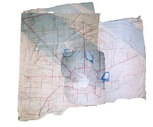
- Total area of village: 1600.5 Acre (666.91Ha)
- Total area available for cultivation : 1398.5 Acre (1383.5 Acre for people, 13 Acre (Kasta) for Panchayat)
- Irrigated Land (Nehri) = 1049 Acre
- Un irrigated Land (Barani) = 262 Acre
- Swampy (Garki) = 87.5 Acre
- Area Unavailable for cultivation : 202 Acre
- Total area of Abadi Area – 95 Acre.
- Builtup – 45 Acre.
- Open Plots or Ghers – 50 Acress
- Total Area of common land (Shamlat) or Phirni around Abadi Area- 55 Acre
- Area under Grazing Land (Dehar) and Ponds – 52 Acres
- Total area of Old settlement - 17.5 Acres
- Total area after extension - 35 Acres
- Total Area after Consolidation - 95 Acres
- Density- 56 persons per acre of Abadi area
Social and Cultural System
- Castes left the village : Baniya (बनिया), Khati (खात्ती)
- Castes Immigrated : Jogi (जोगी), Balmiki (बाल्मीकी)
The villagers did try to settle two more families of Luhar (लुहार) caste in the village. But ironically, they too left the village after selling off the house given to them in charity by the Village Panchayat.
Some more Jat families of different gotra later settled in the village but still, they do not have that much of bond with the original inhabitants of the village. Maybe people have not accepted them till now, because of their belonging to a different gotra. This is a common phenomenon in villages where persons from other gotras are settling down, due to right of daughters in father's property - effected by different legislations framed by governments after Independence. .
Caste Structure of the Village
| Caste | Total Houses | Numbers | Approx. Percentage |
|---|---|---|---|
| Jat जाट | 474 | 2486 | 71.0% |
| Brahmin ब्राह्मण | 45 | 344 | 9.8% |
| Chamar चमार | 48(14+34) | 352 (89 + 263) | 10.0% |
| Dhanak धाणक | 32 | 268 | 7.6% |
| Nai नाई | 5 | 35 | 1.0% |
| Jogi जोगी | 3 | 16 | 0.5% |
| Balmiki बाल्मीकी | 1 | 2 | 0.1% |
| Total Population | 608 | 3503 | 100% |
Social and Cultural system highlights
- The people of all Caste are living in harmony in the village
- Good or bad relations are based on mutual understanding not on caste or religion
- Still on the main occasions both the Brahmins and also the lower castes' people are invited personally which are socially attached to the Jats. And there house are distributed on personal bases.
- The main beliefs are on “Dada Shayam ji” on Dwadshi, 50% of the people make milk products like Kheer on that day and Annual Fair at Doobaldhan-Majra Village and people go there to see the main place of worship of their kul guru.
- The second most important is Ashthami of “Bheemeshwari Devi” and annual fair in the village Beri the people make kheer on this occasion also.
- Also the people have Navami of month the same traditional special food is Kheer.
- Also people worship Lord Shiva and Hanuman ji.
- The hard life of field reflect in the behavior of the people But most of them are true to heart
- People in village take heavy diet of food (Churma of wheet) and Ghee with Lassi in Summer and Chapati of Bajra of in Winter. Though the availability of vegetable is enormous the people used to take the naturally grown vegetables in their fields.
- People like milk and milk products
- The Festivals which are loosing grace are Holi, Dussera and Teej.
- But the Makar Skranti, Diwali are the festivals every person tried to enjoy at its full
Panna and Thola (पान्ना और ठौळा)
As such there is not any “Panna” पान्ना in the Village but there are 6 “Thole” ठौळे in the villages.
- Balyan बाल्याण
- Malvaan मालवाण (Mallane मलंगे)
- Sobhlan सोभलाण (Ganje गंजे)
- Birman (बिरमाण)
- Bhoot (भूत)
- Dangas डंगस - Paddar पद्दड
The Jats, who did not originally belong to village, are still not accepted by the villagers fully though they are here from 200 to 300 years back and using the Gautra of the village though belong to other Gautra.
Social Infrastructure
- Schools - 2
- One Govt. Sr Sec School
- One Shanti Gyan Niketan Schoo (Pvt. School)
- Anganwadi centre: 02
- Veterinary centre: 01
- Panchayat Ghar: 04
- 1 for Jat’s
- 1 for Balmiki’s
- 2 for Chamar’s
- Co-operative milk dairy-01
- Tyre Puncture and repair shop – 0
- Grocery shops - 8
- Electronic and vcd shops – 1
- Temple -02
- Other Religious sites – 08
- Co-Operative Milk Collection Center - 01
- Dispensery – 0
- Post Office - 01
- Silai-Kadhi Shikhsa Center – 0
- Water Workes – 0
- Also people have private water connection from tubewell as the water works unable to distribute water properly.
- Burial ground-01 (with shed)
- Ponds – 05
- Transformer - 03
- One Chaukidar for Birth and Death Registration
Salient Characteristics
- 80 % of the village under Total Sanitation Campaign.
- 90% of the house have LPG Connection
- 40 % of the houses have access to Cable Network.
- 95% of the of the streets are Bricked
- 50 Houses have Telephone connections and 150 Houses have applied for new connection and as the cold response from BSNL there are 26 Mobile Phones in the village
- Periphery of the village is totally bricked and 50 Tarred have a height of 6 Ft to protect from flood
- Nearly 28 tractors of Economical mode are in village for various agriculture work and owner of these have all the necessary infrastructure as this is a major source of income.
- 24 people have Buggies used to pull by bullock for domestic work like fodder and other things also used commercially for bringing the necessary things from nearby village “Beri”
Occupation
- Main Occupation agriculture
- Crops:
- Rabi: Wheat, Mastered, Sugarcane
- Kharif: Bajra, Rice, Jawar, Makki
- Wheat and Bajra are staple crops and other crops are grown for commercial gains
- Yield from one Acre for wheat = 45 to 60 Mun (40 Kg.)
- The Biggest farmer have the Land – 20 Acre
- The Smallest Farmer – Less then 1 Acre
- Average Land per Household : 2.8 Acre
- The Land belong to Jats only and a little portion to Brahmins
- Other casts are the workers on the fields and also workers in House building.
- The Dhanaks are engaged in Weaving and Band.
- About 95 % of people are engaged in agricultural activities.
- Animal husbandry is the ancillary activity and a profit making business. Domestic animals (Buffaloes, cows, sheep) are being reared in the village.
- The Milk collection at Centre 250 kg at one time apart from this 5 milkmen come to village daily to collect money and 2 village people are also in this trade each collect the money nearly 80 – 100 Kg. to sell it in the nearby centre.
Powers of Panchayat
According to the Haryana Panchayati Raj Act,1994 the panchayat has full power like :
- Utilisation of fund
- To impose tax
- To decide BPL and AAY families
- Panchayat has power to impose taxes for raising its financial resources.�
- Auction of Panchayat land (13 Acre – 70000 to 1 Lakh for one Year) also the Ponds for Fisheries on lease (15000 per pond).
- To resolve the internal conflict for maintaining peace in the village
- Gram sabha: all the voters of village are member of gram sabha. 2 meetings are held in one year. All the decision are being taken in Gram Sabha.
- Gram Panchayat: 1 Sarpanch, 11 Panches.
- GP is elected body.
- Decisions are being taken in Gram Sabha
- Village Development Committee, a body of elderly people who are representative of all the segment of society headed by Sarpanch, is responsible for utilisation of fund in the village.
- Block Panchayat: there is a Block Panchayat at block level.
- District Panchayat: Grants of GP are being sanctioned by District Panchayat.
There is no DPC in Haryana state.
Potential of Village
- Fertile land is available for cultivation
- Better connectivity
- Well developed animal husbandry
- Informal Panchayat System is very much efficient
- Prevalence of barter system
- Required awareness among women
Problems of Village
- Too much dependence on agriculture
- Ground water is not suitable for agriculture in most of the agriculture area in the village
- Kharif crop is entirely dependent on rainfall
- Traditional cropping pattern
- Per capita land holding is very less
- Loss of fertile land due to Brick- Manufacturing and salinity
- Big Trees and good vegetation cover is dieing because of salinity and awareness about Agro-Forestry is Absent.
- Lust for Agriculture Water in the Neighboring village leads to break the canal embankment leads to flood and marshy land of one side of the village
- Village Youths have not any knowledge of Govt. schemes for them.
- Prevalence of “Nasha (Charas, Ganja, Smack, Sharab and Medicine and Injection is increasing)
- Hokka culture is dieing with the increasing habbit of “Bidi” and the discussions become cheap and mass distructive.
- Increasing Negative thinking among small and medium age groups.
- Exodus of good people and their breaking off contacts with village.
- Increasing trend of culture of "small family"
- Low awareness
- Prevalence of superstition. sepecially among women
Findings
- Promotion of education through awareness programmes
- Change in traditional mindset through awareness
- Programme about modern world
- Replacement of traditional cropping pattern through cash crops
- Introduction of co-operative farming
- Promotion of people's participation during Gram Sabha meetings
- Documentation of local Folk
- Regular arrangement for cultural programmes
- Proper guidance for investment of savings
- Formation of SHG for women for better participation in social life
Back to Jat Villages
- ↑ Ram Sarup Joon: History of the Jats/Chapter V, p.69-70, S.No.2

