Anjan Bihari
| Author:Laxman Burdak, IFS (R) |


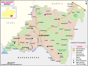
Anjan Bihari (अंजन बिहारी) is a village in Tirodi tahsil in Balaghat district of Madhya Pradesh. It is mentioned as Anjanavataka (अंजनवाटक) in Indore Plates of 23rd year of Pravarasena II[1]
Variants
- Anjanavataka (अंजनवाटक) in Indore Plates of 23rd year of Pravarasena II[2]
Location
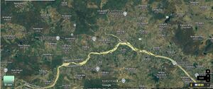
Anjan Bihari is a Village located on north bank of Wainganga River. It is in Tirodi Taluka , Balaghat district and Madhya Pradesh State. Anjan Bihari is 13 km distance from Sub District Head Quarter Tirodi and it is 74 km distance from District Head Quarter Balaghat. Nearest Statutory Town is Katangi in 28 km Distance.[3]
Jat Gotras Namesake
- Anjan (अंजन) (Jat clan) → Anjan Bihari (अंजन बिहारी) is a village in Tirodi tahsil in Balaghat district of Madhya Pradesh. It is mentioned as Anjanavataka (अंजनवाटक) in Indore Plates of 23rd year of Pravarasena II[4]
History
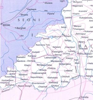
Anjanavataka (अंजनवाटक), mentioned in Indore Plates of 23rd year of Pravarasena II, has been identified by V.V. Mirashi[5] with Anjanwadi (अंजनवाड़ी), about 5 miles to the south-east of Kosamba. But there is no village of this name but there is village named Anjan Bihari (अंजन बिहारी) located in south-east of Kosamba. Hence we propose that Anjanavataka (अंजनवाटक) is same as Anjan Bihari (अंजन बिहारी) is a village in Tirodi tahsil in Balaghat district of Madhya Pradesh.
Indore Plates of 23rd year of Pravarasena II
Indore Plates of 23rd year of Pravarasena II[6] may have been issued from the royal capital Pravarapura. The object of the present inscription was to record the grant of a village (the name of which is unfortunately lost owing to the writer’s carelessness) which lay in the mārga of Gepuraka (गेपुरक), to the north of Aramaka (आरामक), to the east of Kobidarika (कोबिदारिका) to the south of Koshambaka (कोशम्बक) and to the west of Anjanavataka (अंजनवाटक). (p.39)
As no definite information is available about the original findspot of the present plates, it is not easy to locate the places mentioned in them; and none have been identified so far. After a good deal of search for them, I have been able to find some of them in the respective directions in the Balaghat District of Madhya Pradesh.
Koshamba (कोशम्ब) which lay to the north of the donated village is probably identical with Koshambakhanda which Pravarasena II granted by his Tirodi plates. As shown elsewhere, the latter is identical with Kosamba, 6 miles to the south of Tirodi.
Anjanavataka (अंजनवाटक) which defined the eastern boundary of the donated village is probably Anjanwadi (अंजनवाड़ी), about 5 miles to the south-east of Kosamba.
Kobidarika (कोबिदारिका) which lay to the west of the donated village may be Kunargaon, 4 miles south by west of Kosamba.
These three villages thus lie in the same directions as those stated in the present grant.
Gepuraka (गेपुरक) and Aramaka (आरामक) cannot, however, be found in the neighbourhood of these villages. If these identifications are correct, the grant may have originally belonged to the Balaghat District. (p.40)
Notable persons
Gallery
Population
External links
References
- ↑ Corpus Inscriptionum Indicarum Vol.5 (inscriptions of The Vakatakas), Edited by Vasudev Vishnu Mirashi, 1963, Archaeological Survey of India, p.38-42
- ↑ Corpus Inscriptionum Indicarum Vol.5 (inscriptions of The Vakatakas), Edited by Vasudev Vishnu Mirashi, 1963, Archaeological Survey of India, p.38-42
- ↑ https://www.onefivenine.com/india/census/village/Balaghat/Tirodi/Anjan-Bihari
- ↑ Corpus Inscriptionum Indicarum Vol.5 (inscriptions of The Vakatakas), Edited by Vasudev Vishnu Mirashi, 1963, Archaeological Survey of India, p.38-42
- ↑ Corpus Inscriptionum Indicarum Vol.5 (inscriptions of The Vakatakas), Edited by Vasudev Vishnu Mirashi, 1963, Archaeological Survey of India, p.38-42
- ↑ Corpus Inscriptionum Indicarum Vol.5 (inscriptions of The Vakatakas), Edited by Vasudev Vishnu Mirashi, 1963, Archaeological Survey of India, p.38-42

