Derawar Fort


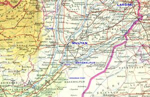
Derawar Fort is in Bahawalpur (Hindi: बहावलपुर, Punjabi/Urdu: بہاولپور) District in the Punjab province in Pakistan. Bahawalpur was also a princely state, stretching along the southern bank of the Sutlej and Indus Rivers, with its capital city at Bahawalpur.
History
James Tod writes Beeji Rao had succeeded as Bhatti Chief in S. 870 (A.D. 814). He commenced his reign with the teeka-dour against his old enemies, the Barahas, whom be defeated and plundered. In S. 892, he had a son by the Boota queen, who was called Deoraj. The Barahas and Langahas once more united to attack the Bhatti prince ; but they were defeated and put to flight. Finding that they could not succeed by open warfare, they had recourse to treachery. Having, under pretence of terminating this long feud, invited young Deoraj to marry the daughter of the Baraha chief, the Bhattis attended, when Beeji Rai and eight hundred of his kin and clan were massacred. Deoraj escaped to the house of the Purohit (of the Barahas, it is presumed), whither he was pursued. There being no hope of escape, the Brahmin threw the Brahminical thread round the neck of the young prince, and in order to convince his pursuers that they were deceived as to the object of their search, he sat down to eat with him from the same dish. Tanot was invested and taken, and nearly every soul in it put to the sword, so that the very name of Bhatti was for a while extinct. [1]
Deoraj remained for a long time concealed in the territory of the Barahas ; but at length he ventured to Boota, his maternal abode, where he had the happiness to find his mother, who had escaped the massacre at Tanot. She was rejoiced to behold her son's face, and " waved the salt over his head," then threw it into the water, exclaiming, " thus may your enemies melt away !" Soon tired of a life of dependence, Deoraj asked for a single village, which was promised ; but the kin of the Boota chief alarmed him, and he recalled it, and limited his grant to such a quantity of land as he could encompass by the thongs cut from a single buffalo's hide : and this, too, in the depth of the desert. For this expedient he was indebted to the architect Kekeya, who had constructed the castle of Bhatner. [2]
This deception practised by the Bhatti chief to obtain land on which to erect a fortress is not unknown in other parts of India, and in more remote regions. Bhatner owes its name to this expedient, from the division (bhatna) of the hide.[3]
Deoraj immediately commenced erecting a place of strength, which he called after himself Deogarh, or Deorawal, on Monday, the 5th of the month Mah (sudi) the Pookh Nikhitra, S. 909 (853 AD). [4]
James Tod writes that Bhatti Chief Deoraj had two sons, Moond and Chadu ; the last, by a wife of the Baraha tribe, had five sons, whose descendants were styled Chada Rajputs. Deoraj excavated several large lakes in the territory of Khadal (in which Deorawal is situated) ; one at Tanot is called Tanosar ; another, after himself, Deosar. [5]
James Tod writes that When the sons of Bhatti Rao Raningdeo became converts to Islam, in order to avenge their father's feud with the Rathore prince of Nagore, they forfeited their inheritance of Poogul and Marot, and thenceforward mixed with the Abhoria Bhattis, and their descendants are termed Momun Musalman Bhutti. [6]
On this event, Kailan, the third son of the Rawal Kehar II, took possession of the forfeited lands, and besides Beekampur, regained Deorawul, which had been conquered by their ancient foes, the Dahya Rajputs.[7]
Rao Kailan had established his authority over nine castles, heads of districts, viz., Asini Kot or Aswini-kote, Beekumpoor, Marote, Poogul, Deorawul, Kerore (twenty-two coss, or about forty miles, from Bahawulpore), Guman, Bahun, Nadno, and Matailoh, on the Indus. [8]
James Tod[9] writes that The warriors assembled under Visaladeva Chauhan against the Islam invader included the ruler of Derawar Fort. When the summons reached the Bhomia Bhatti of Derawal all obeyed.
The Cholistan Desert
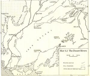
East of Bahawalpur is the Cholistan Desert which covers an area of about 15,000 km2 and extends into the Thar Desert of India. The region was once watered by the Hakra River, known as the Saravati in vedic times. At one time there were 400 forts in the area and archaeological finds around the Derawar Fort, the only place with a perennial waterhole, indicate that it was contemporaneous with the Indus Valley Civilisation. The average annual rainfall is only 12 cm, and the little cultivation there is, is made possible by underground wells, drawn up by the camels. The water is stored in troughs, built by the tribes, between sandhills and din waterholes called tobas. The people are racially similar to those in Rajasthan - tall, with sharp features. They live in large, round, mud and grass huts, usually built on the top of sandhills. On the whole, they are pastoral and nomadic. The main tribes are the Chhachhar, Mehr, Lar, Paryar, Channar, Chandani and Bohar. The forts here were built at 29 km intervals, which probably served as guard posts for the camel caravan routes. There were three rows of these forts. the first line of forts began from Phulra and ended in Lera, the second from Rukhanpur to Islamgarh, and the third from Bikaner to Kapoo. They are all in ruins now, and you can see that they were built with double walls of gypsum blocks and mud. Some of them date back to 1000 BC, and were destroyed and rebuilt many times.
Notable persons
External links
References
- ↑ James Tod: Annals and Antiquities of Rajasthan, Volume II, Annals of Jaisalmer, p.211
- ↑ James Tod: Annals and Antiquities of Rajasthan, Volume II, Annals of Jaisalmer, p.211
- ↑ James Tod: Annals and Antiquities of Rajasthan, Volume II, Annals of Jaisalmer, p.211, fn.2
- ↑ James Tod: Annals and Antiquities of Rajasthan, Volume II, Annals of Jaisalmer, p.212
- ↑ James Tod: Annals and Antiquities of Rajasthan, Volume II, Annals of Jaisalmer, p.215-216
- ↑ James Tod: Annals and Antiquities of Rajasthan, Volume II, Annals of Jaisalmer, p.232
- ↑ James Tod: Annals and Antiquities of Rajasthan, Volume II, Annals of Jaisalmer, p.232
- ↑ James Tod: Annals and Antiquities of Rajasthan, Volume II, Annals of Jaisalmer, p.236,fn-2
- ↑ James Tod: Annals and Antiquities of Rajasthan, Volume II,Annals of Haravati,p.414-416
Back to Jat Places in Pakistan

