Ghatshila
| Author:Laxman Burdak, IFS (R) |

Ghatshila (घाटशिला) is a town and block in East Singhbhum District of Jharkhand State, India.
Variants
Location
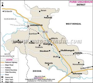
Ghatshila is located at 22.60°N 86.48°E. It has an average elevation of 103 m (338 ft). It is 45 km from Jamshedpur. The town is located on the bank of the Subarnarekha River, and it is situated in a forested area. It contains a railway station on the main line of the South Eastern Railway. Ghathsila was formerly the headquarters of the kingdom of Dhalbhum.
Ghatsila is a Town in Ghatshila Block in East Singhbum District of Jharkhand State, India. It is located 45 KM towards East from District head quarters Jamshedpur. It is a Block head quarter. Ghatsila Pin code is 832303 and postal head office is Ghatsila . Barajuri ( 2 KM ) , Upparbandha ( 3 KM ) , Moubhandar(east) ( 5 KM ) , Moubhandar(west) ( 5 KM ) , Moubhandar(north) ( 5 KM ) are the nearby Villages to Ghatsila. Ghatsila is surrounded by Musabani Block towards South , Dhalbhumgarh Block towards South , Dumaria Block towards South , Chakulia Block towards East.[1]
Ghatsila has its diversity with dams, falls, rivers, forest, mountains and valley. The scenes are breathtaking especially at sunset. It has a township as well as a village touch. There are areas where people still do farming for a living; these areas are untouched and unexplored.
History
Legend says that the royal family of the Kingdom of Dhalbhum had originated from the northwest (Dhar Madhya Pradesh and Mandu), located at the border of Rajasthan.
Legend goes on to say that around 1300 AD, Dhalbhum was wrested from him by Raja Jagat Deo from Jagner near Dholpur and belonged to Dhar in Malwa, who later assumed the name of Raja Jagannath Deo Dhabal Deb I. Originally Raja Jaganath Deo Dhabal Deb I belonged to the Parmar clan from Dhar in Malwa. They established themselves by conquest in western part of Bengal, the area commonly known as Jungle Mahals. These families kept up a sort of semi-royal state and dignified their heir-apparent and those in immediate succession with title of honor, which denotes precedence. Thus, in the Dhalbhum family, the oldest son of the ruling king (Rajah) took the title of Jubraj, the second that of Hikkim, the third of Barathakur, the fourth that of Kuar, the fifth that of Musib and the rest Babu.
The area of the kingdom of Dhalbhum was approximately 1,200-square-mile (3,100 km2). Raja Jaganath constructed the Rankini Mandir at Galudih. But due to some problem, he shifted the Kali temple along with all the associates and other people to Ghatsila and built up a temple of goddess Kali, beside Ghatshila police station which is known as Rankini Mata.
Ghatshila was the administrative capital of Dhalbhum & Jamboni Zamindari. Ghatshila has several palaces, schools and administrative buildings constructed by the rulers of Dhalbhum zamindari.
Raja Jagadish Chandra Deo Dhabal Deb of Dhalbhum & Jamboni Zamindari was the last recognised ruler of Dhalbhum & Jamboni Zamindari.
घाटशिला
जमशेदपुर से 60 किमी की दूरी पर स्थित, घाटशिला का सुंदर सा शहर सुरम्य पहाड़ियों, शांत झीलों और प्राचीन झरनों से समृद्ध है। मुख्य आकर्षण शहर के बाहरी इलाके में स्थित फूलडुंगरी हिल्स है। ट्रेकर्स और प्रकृति प्रेमियों के लिए मनोरम स्थल, पहाड़ियों की यह श्रृंखला घाटशिला के शानदार दृश्य प्रस्तुत करती है। शहर का एक और दर्शनीय स्थल आकर्षण है, शहर के केंद्र से 5 किमी की दूरी पर स्थित बुरूडीह झील। घने जंगलों और हरी भरी पहाड़ियों से घिरी, कृत्रिम झील स्थानीय लोगों के बीच एक प्रसिद्ध पिकनिक स्थल है। घाटशिला भव्य धारागिरी जलप्रपात के लिए भी जाना जाता है, जो 25 फीट की ऊँचाई से गिरता है। इस जलप्रपात को देखने जाने का सबसे अच्छा समय मानसून के दौरान होता है जब वे अपने शानदार रूप में प्रवाहित होते हैं। घाटशिला का विश्व-प्रसिद्ध फिल्म निर्माता सत्यजीत रे के साथ भी एक विशेष संबंध है। ऑस्कर विजेता निर्देशक ने अपने अधिकांश उपन्यासों को घाटशिला में लिखा, जिसमें उनकी अपु ट्राइलॉजी – पाथेर पांचाली, अपराजिता और अपूर संसार शामिल हैं।[2]
Jat clans
Following Jat clans have similarity with places shown in bold in this tahsil/block. There is need to further research this correlation.
Villages in Block
Amachuria, Amainagar, Asna Tola, Badbil Khas, Badbil Tola, Badisai, Bagaldih, Bagalgora, Baguria Tola Sukrigadia, Baitalpur Khas, Balam Khas, Baliama 1, Balidih, Baliguma, Bandih 1, Bangora, Bara Purna Bankati, Baradhadhika, Barajuri Tola, Barapahar, Bardih, Basadera, Berahatu, Bhaduatola, Bhamaradih, Bhumru, Brindabanpur, Burudih 1, Chakdoha, Chandrarekha, Chandrarekha Tola, Changjora Tola, Chapari, Charaigora, Charari, Chekam, Chengjora, Chengjora Tola, Chholagora 1, Chhota Dhadika, Chhota Jamuni, Chhota Khursi, Chhota Khursi Tola, Churinda, Deoli Khas, Deoli Tola, Dhakpathar Tola, Dhamakbeda, Dhangakamal, Dharambahal Tola, Dhikuli 1, Dhobani, Digadih, Digha, Duberajpur Basti, Dubrajpur Tola, Dynemeri, Edelbera 1, Gahandih, Galudih, Gandhania Khas, Gandhania Tola, Ghatiduba, Ghortola, Ghutia, Guraghore, Guraghore Tola, Haludbani 1, Hiraganj, Hiraganj Tola, Hullung, Jagannathpur, Jagannathpur Tola, Jambad, Jhaparisole, Jhaparisole Tola, Jharbera, Jharbera Tola, Kalajhore Tola, Kalajhortolabhutiasole, Kalamati Khas, Kalamati Tola, Kalapathar, Kalapathar Khas, Kalapathar Tola, Kamarigoda, Kamarigoda Tola, Kanimahuli, Kankarisole Khas, Kankarisole Tola, Kasia Khas, Kasia Tola, Kaspani, Kathsole, Kendoposi, Kesharpur, Kharikasole, Khutadih, Kitadih, Kitadih Tola, Kuliana, Leda, Leda Tola, Lohamalia, Mahilidih, Mahishduba, Mahtan Khas, Mahtan Tola, Murakati, Narsinghpur Khas, Narsinghpur Tola, Nischintpur, Paharpur 1, Paharpur 2, Pairagudi Khas, Pairagudi Tola, Part Mahulia, Phuljhore Tola, Phuljhore Tola Khas, Phulpal, Pindrabad, Pithati, Pukharia, Pungora, Puranapani, Puturu, Raghunathpur, Rajabasa, Rajabasa Tola, Ramchandrapur, Salboni, Sindariyam Tola, Sindriyam Basti, Sirisboni, Sirisboni Tola, Soradbar, Soradbar Tola, Sushani Jobni, Susniguria, Tamakpal Tola, Tamakpal Tola Baridih, Tetlakocha, Thakurbari, Tikari, Tola Jojobera, Ulda Tola Hatchali Bazar, Ulda Village, Upper Powda, Upper Powda Tola, Upperdigha, Yuktidih,

