Kasur
| Author:Laxman Burdak, IFS (Retd.) |

Kasur (Hindi: कसूर, Urdu/Punjabi: قصور) (Qasur) is a city and district in the Punjab province of Pakistan.
Origin of name
Tahsils in the District
Jat Gotras
Click to see Jat Gotras in Kasur
Location
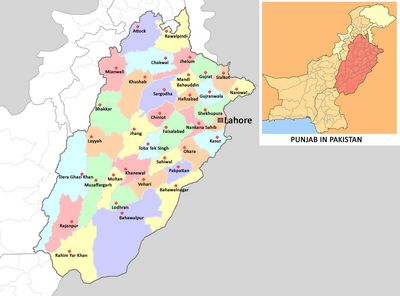
Kasur is located adjacent to the border of Ganda Singh Wala between Pakistan and the India. At east-southern border it is circled by the Sutlej River and at west-northern border of district the river Ravi flows. The famous man made forest Changa Manga is located at western direction of the city Kasur about 30 miles away.
History
Historically the city of Kasur was named by ancient Aryan tribe of Kambojas who migrated from Mittani and Kussara and belonged to Ancient King Pithana of Mesopotamian Kussara. This fact is also endorsed by renowned folk Baba Bulay Shah that all Pathans of Kasur would become weavers very soon. The town of Khudian was built by ancient Aryan Iranian Kambojas of Kasur who claim descent from Saman Khuda. A village Khoda near Khudian is also inhabited by Kambojah Clan. The same clan Kambojas also claims to be offs prings of Kumbakarna and Rama. Ancient town of Rajowal of Kambojas is also related to Kambojas of Khemkaran.
According to a traditional belief, Kasur was founded by Prince Kusha, the son of Lord Rama, while Lahore, called Lavapuri in ancient times, was founded by his brother Prince Lava. Kasur had been allotted by the Mughals to Pashtuns or Afghans of Kabul and still contains a colony of Pashtuns. However the site was occupied by a Rajput town long before the period of Muslim rule.
According to some historians, the name Kasur is derived from Kashawar, the same way Lahore is said to be taken from Lahawar. Kush, the son of Ram Chander or Rama, is said to have founded Kasur like his brother Loh or Lav is said to have founded Lahore. However, some historians opine that Kasur is a Persian word and a plural of “Kasar” or “Qasar” (meaning palace), which the name was given during the times Kasur was a remarkable colony of Pathans, perhaps the most remarkable on this side of Indus.
In 997 CE, Sultan Mahmud Ghaznavi, took over the Ghaznavid dynasty empire established by his father, Sultan Sebuktegin, In 1005 he conquered the Shahis in Kabul, and followed it by the conquests of northern Punjab region. The Delhi Sultanate and later Mughal Empire ruled the region. The Punjab region became predominantly Muslim due to so called missionary Sufi saints & their swords the landscape of Punjab region.
Sindhu Chiefs Of Wadala: Ram Sarup Joon[2] writes that Sardar Mokal Singh, leader of this dynasty, founded the village of Mokal near Daska. After several generations Chaudhary Durga Das was appointed Chaudhary on behalf of the Moghuls. Later Sardar Mahtab Singh occupied 82 villages due to the weakness of the Mughal emperor. He was a member of Bhangi Misal.
Bhim Singh Dahiya[3] writes that A place is named Gasur (Kasur) and Gusur is a clan name among the Jats.
Visit by Xuanzang in 633 AD
Alexander Cunningham [4] writes about Kusawar, or Kasur.
[p.199]: According to the traditions of the people Kasur was founded by Kusa, the son of Rama, after whom it was named Kusawar, which, like the contemporary city of Lohawar, has been slightly altered in pronunciation by the transposition of the vowels. The town stands on the high bank of the old bed of the Bias river, 32 miles to the south-south-east of Lahor,1 and is popularly said to have once possessed bāra kilah, or " twelve forts," of which seven only are now standing. Its antiquity is undoubted. There are, however, no buildings or remains of any consequence ; but the extent of the ruins is very great ;2 and the situation on the high-road between Lahor and the old point of junction of the Bias and Satlej, opposite Firuzpur, is so favourable that it must have been occupied at a very early date. The position also is a strong one, as it is covered by the Bias river on the south, and by ravines on the other sides. It is quite impossible to define the limits of the ancient city, as the suburbs of the present town are entirely covered with the ruins of
1 See Map No. VI.
2 I speak from personal survey and examination ; but I can also refer to Lieutenant Barr's ' Kabul and the Panjab,' p. 409, — " Kasur, a large and ancient town, that in former days must have covered an extensive area, as its ruins are interminable."
[p.200]: tombs and masjids, and other massive buildings ; but it could not, I think, have occupied less than one square mile, which would give a circuit of about four miles for the walled town. Several of the tombs are fully a mile distant from the present town ; and at least one-half of the intervening space, which is thickly covered with ruins, would appear to have belonged to the ancient city. It seems probable, therefore, that this must be the "great town" on the eastern frontier of Taki, that is, on the Bias river, at whicb Hwen Thsang halted for a month on his way from the capital of Taki to Chinapati. Unfortunately, he has omitted the usual details, and we have only the one bare fact, that it was situated somewhere on the right bank of the Bias opposite Lahor, to guide us in determining its position.
Notable persons
References
Back to Jat Places in Pakistan

