Coorg
| Author:Laxman Burdak, IFS (R) |

Coorg (कुर्ग) or Kodagu (कोडगू) is a district in Karnataka, India. Before 1956, it was an administratively separate Coorg State,[1] at which point it was merged into an enlarged Mysore State. Kodagu is home to the native speakers of the Kodava language.
Variants
- Kodagu (कोडगू) (कर्नाटक) (AS, p.162)
- Kurga (कुर्ग) (कर्नाटक) (AS, p.208)
- Kroda (क्रोड देश) (AS, p.247)
Location
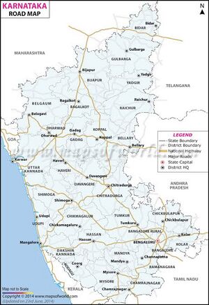
It occupies an area of 4,102 square kilometres in the Western Ghats of southwestern Karnataka. The district is bordered by Dakshina Kannada district to the northwest, Kasargod district of Kerala to the west, Hassan district to the north, Mysore district to the east, Kannur district of Kerala to the southwest, and the Wayanad district of Kerala to the south. Kodagu is located on the eastern slopes of the Western Ghats. It is a hilly district, the lowest elevation of which is 120 metres (390 ft) above sea-level. The highest peak, Tadiandamol, rises to 1,750 metres (5,740 ft), with Pushpagiri, the second highest, at 1,715 metres (5,627 ft). The main river in Kodagu is the Kaveri (Cauvery), which originates at Talakaveri, located on the eastern side of the Western Ghats, and with its tributaries, drains the greater part of Kodagu.
Jat clans
- Kurk (कुर्क): They are said to have originated from Nagavanshi King Krikalasa (कृकलास). Kerk, Kruk, Kurk, Karak is a tribe mentioned by Sir H. M. Elliot[2] living in Sindh.
- Kurka (कुरका) gotra Jats live in Tonk district in Rajasthan.
History
The Kodavas were the earliest inhabitants and agriculturists in Kodagu, having lived there for centuries. Being a warrior community as well, they carried arms during times of war and had their own chieftains. The Haleri dynasty, an offshoot of the Keladi Nayakas, ruled Kodagu between 1600 and 1834. Later the British ruled Kodagu from 1834, after the Coorg War, until India's independence in 1947. A separate state (called Coorg State) until then, in 1956 Kodagu was merged with the Mysore State (now Karnataka).
Coorg in British India: In 1834, the East India Company annexed Kodagu into British India, after deposing Chikka Virarajendra of the Kodagu kingdom, as 'Coorg'. The people accepted British rule peacefully. British rule led to the establishment of educational institutions, introduction of scientific coffee cultivation, better administration and improvement of the economy.[3]
कुर्ग या 'कोडगू'
विजयेन्द्र कुमार माथुर[4] ने लेख किया है ...कुर्ग (AS, p.208) सुदूर दक्षिण में पश्चिमी तट पर अवस्थित है. कुर्ग का प्राचीन नाम 'कोडगू' था, जो कन्नड़ शब्द 'कुडू' (ढलवाँ पहाड़ी) का अपभ्रंश है। क्रोड देश भी कुर्ग का ही एक अन्य प्राचीन नाम है।
कुर्ग या 'कोडगू' का परिचय
कुर्ग या 'कोडगू' कर्नाटक का एक प्रांत और ज़िला है। यह मुख्य पर्वतीय स्थल है, जिसकी समुद्र तल से ऊँचाई लगभग 1525 मीटर है। कुर्ग का प्राचीन नाम 'कोडगू' था, जो कन्नड़ शब्द 'कुडू' (ढलवाँ पहाड़ी) का अपभ्रंश है। क्रोड देश भी कुर्ग का ही एक अन्य प्राचीन नाम है। कुर्ग नाम अंग्रेज़ों का दिया हुआ था, जिसे बदलकर फिर से कोडगू कर दिया गया है। मदिकेरी इसका मुख्यालय है। पश्चिमी घाट पर स्थित पहाड़ों और घाटियों का प्रदेश कुर्ग दक्षिण भारत का प्रमुख पर्यटन स्थल है।
प्राकृतिक सुन्दरता: कुर्ग के पहाड़, हरे-भरे वन, चाय और कॉफी के बाग़ बड़े ही आकर्षक हैं। कावेरी नदी का उद्गम स्थान कुर्ग अपनी प्राकृतिक ख़ूबसूरती के अतिरिक्त हाइकिंग, क्रॉस कंट्री और ट्रेल्स के लिए भी मशहूर है। मदिकेरी, जो कि कुर्ग का मुख्यालय है, को दक्षिण का स्कॉटलैंड कहा जाता है। यहाँ की धुंधली पहाड़ियाँ, हरे वन, कॉफी के बाग़ और प्रकृति के ख़ूबसूरत दृश्य मदिकेरी को अविस्मरणीय पर्यटन स्थल बनाते हैं। मदिकेरी और उसके आस-पास बहुत से ऐतिहासिक और धार्मिक स्थल भी हैं। यह मैसूर से 125 कि.मी. की दूरी पर पश्चिम में स्थित है और कॉफी के उद्यानों के लिए भी बहुत प्रसिद्ध है।
इतिहास: 1600 ईसवी के पश्चात् लिंगायत राजाओं ने कुर्ग पर शासन किया और मदिकेरी को अपनी राजधानी बनाया। मदिकेरी में उन्होंने मिट्टी का क़िला भी बनवाया था। 1785 में मैसूर के टीपू सुल्तान की सेना ने इस साम्राज्य पर अधिकार करके यहाँ अपना अधिकार जमा लिया। चार वर्ष बाद कुर्ग ने अंग्रेज़ों की सहायता से आज़ादी पाई, तब यहाँ के राजा वीर राजेन्द्र ने पुर्ननिर्माण का कार्य प्रारम्भ किया। 1834 ई. में अंग्रेज़ों ने इस स्थान पर अपना अधिकार कर लिया और यहाँ के अंतिम शासक पर मुकदमा चलाकर उसे कारागार में डलवा दिया। 'काडगू' कुर्ग का प्राचीन नाम था, जिसे अंग्रेज़ों ने कुर्ग कर दिया था। लेकिन अब फिर से इसका नाम बदलकर 'कोडगु' कर दिया गया है। यहाँ की भाषा कुर्गी है। स्थानीय लोग इसे 'कोडवक्तया कोडवा' कहते हैं।
मदिकेरी के अलावा कुर्ग के अन्य मुख्य क्षेत्र भी हैं- 1. विराजपेट, 2. सोमवारपेट, 3. कुशलनगर
यहाँ के निवासियों में एक अलग तरह की खुशमिज़ाज़ी है, जो कुदरत के क़रीब रहने वाले हर इंसान में दिखाई देती हैं। दक्षिण भारत के दूसरे इलाकों से कुर्ग हर मायने में अलग है। कुर्गी लोग आमतौर पर गोरे, आकर्षक और अच्छी कद-काठी वाले होते हैं। इन लोगों की वेशभूषा भी प्राय: अलग-अलग होती है। कुर्गी पुरुष काले रंग का एक विशेष प्रकार का परिधान पहनते हैं, जिसे स्थानीय भाषा में 'कुप्या' कहा जाता है।
संदर्भ: भारतकोश-कुर्ग
ब्रह्मगिरि
विजयेन्द्र कुमार माथुर[5] ने लेख किया है ... 4. ब्रह्मगिरि (AS, p.649) = कुर्ग के दक्षिण में स्थित पर्वतमाला
External links
References
- ↑ Chisholm, Hugh, ed. (1911). "Coorg" . Encyclopædia Britannica. 7 (11th ed.). Cambridge University Press. pp. 91–92. "District Census 2011". Census2011.co.in. 2011.
- ↑ The History of India, as Told by Its Own Historians/Note (C).- Ethnological,pp.508-511
- ↑ Belliappa, C P (4 August 2015). "Call for freedom from a tiny village" (Bangalore). Deccan Herald.
- ↑ Aitihasik Sthanavali by Vijayendra Kumar Mathur, p.208
- ↑ Aitihasik Sthanavali by Vijayendra Kumar Mathur, p.649

