Kurula
| Author:Laxman Burdak, IFS (R) |

Kurula (कुरूळ) was one of the kingdoms of Dakshinapatha subdued by Samudragupta. Its ruler was Mantaraja. Kurula village is in Sheragada tahsil of Ganjam district in Orissa. Kurula is famous for the ancestral goddess named Kurulai. [1]
Location
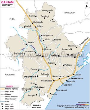
Kurula village is located in Seragad Tehsil of Ganjam district in Odisha, India. It is situated 64km away from sub-district headquarter Seragad and 56km away from district headquarter Chatrapur. As per 2009 stats, Kurula village is also a gram panchayat. The total geographical area of village is 198 hectares. Kurula has a total population of 2,542 peoples. There are about 502 houses in Kurula village. Hinjilicut is nearest town to Kurula which is approximately 8km away.[2]
Kurula is a Telegu Kalingi dominant village but several other caste people also residing in the village. The other community people like- Brahmins, fisherman, Carpenter, cloth weavers, washer man community living in the village. There are other tagging villages nearby the village are Naibandha, Baisipal and Mahirakana. This village celebrates Hara Gouri Puja once in three year. The village situated bank of Ghodahada River.[3]
Origin
Variants
Jat clans
History
Allahabad pillar inscription of Samudragupta mentions King named Maṇṭarāja (N. 1, L. 19) in the list of Names of Feudatory Kings and High Officers by Tej Ram Sharma [4], a King of Kurula, one of the rulers of Dakshinapatha defeated by Samudragupta. In this name the first part is Manta and the second is Raja. The meaning of the first part is not clear to the historians. It is clearly not a Sanskrit word. As Woolner has pointed out words with cerebrals are often non-Aryan or influenced by non-Aryan elements.[5] Another possibility is that these names show dialectal elements. We may derive it from an artificial root 'mant' to act as inter mediator.[6]
Tej Ram Sharma [7] writes about 8. Kurala (कुराळ) mentioned in (No. I, L. 19) : Allahabad pillar inscription of Samudragupta. ....It has been mentioned as one of the kingdoms of Daksinapatha subdued by Samudragupta. Its ruler was Mantaraja. Fleet suggests that Kauralaka is a mistake for Kairalaka, denoting the well known province Kerala in the South of India. 613 D.R. Bhandarkar 614 identifies this Kerala with the Sonpur
Personal and geographical names in the Gupta inscriptions 259
territory in C.P. round about Yayatinagara where the author of the Pavanaduta locates the Keralas. Barnett identified it with modern village Korada in South India. 615 Kurala is taken by Kielhorn 616 to be the same as Kunala mentioned in the Aihole inscription of Pulakesin II 617 and identified with the Kolleru lake between the Godavari and the Krishna. 618 But DR. Bhandarkar 619 objects to this view on the ground that the Kolleru lake must have been included in the kingdom of Verigi mentioned later on 620 in the same list in the inscription. G.Ramdas 621 seems to be right when he observes that Kurala must be the plain country of the Ganjam district to the north-east of the Mahendra hill now chiefly occupied by the Oriyas.
615. Calcutta Review, Feb. 1924, p. 253 note : Cf. Political History of Ancient India by H. C. Raychaudhuri . pp. 452-53.
616. Epigraphia Indica. VI. p. 3, f. n. 3 : Diskalkar, Selections From Sanskrit Inscriptions by D. B. Diskalkar. Vol. I, part II, p. 35.
617. Diskalkar, Selections From Sanskrit Inscriptions by D. B. Diskalkar. p. 130, v. 28.
618. Cf. Sircar, Select Inscriptions by D. C. Sircar . p. 265, f. n. I.
619. Diskalkar, Selections From Sanskrit Inscriptions by D. B. Diskalkar. p. 35.
620. No. I, L. 20.
621. Indian Historical Quarterly, Calcutta. Vol. I, p. 685.
कौराल
विजयेन्द्र कुमार माथुर[8] ने लेख किया है ...कौराल (AS, p.243) गुप्त सम्राट समुद्रगुप्त की प्रयाग प्रशस्ति में वर्णित एक प्रदेश का नाम है- 'कौसलक महेंद्र महाकांतार व्याघ्रराज, कौरल(ड)क मंटराज पैष्ठपुरक महेंद्र गिरि।' इतिहासकार हेमचन्द्र रायचौधरी के मत में इस नाम से केरल, जिसकी राजधानी महानदी पर स्थित 'ययातिनगर' में थी, का बोध होता है। डॉ. बारनेट के अनुसार यह दक्षिण का कोराड़ नामक ग्राम है (कलकत्ता रिव्यू, फ़र्वरी, 1924) और डॉ. कीलहार्न के मत में कोलेयर झील का तटवर्ती क्षेत्र (कीलहार्न, एपिग्राफ़िका इंडिका, जिल्द 6, पृ. 3)
External links
References
- ↑ http://www.onefivenine.com/india/villages/Ganjam/Sheragada/Kurula
- ↑ https://villageinfo.in/odisha/ganjam/seragad/kurula.html
- ↑ http://www.onefivenine.com/india/villages/Ganjam/Sheragada/Kurula
- ↑ Personal and geographical names in the Gupta inscriptions/Names of Feudatory Kings and High Officers, pp.43-44
- ↑ A.C. Woolner, 'Prakrit and non-Aryan strata in the vocabulary of Sanskrit', p. 70.
- ↑ Sanskrit-English Dictionary by Monier Williams. p. 775, col. 2
- ↑ Personal and geographical names in the Gupta inscriptions/Place-Names and their Suffixes,p.258-259
- ↑ Aitihasik Sthanavali by Vijayendra Kumar Mathur, p.243

