Ratnagiri
| Author:Laxman Burdak, IFS (R) |

Ratnagiri (रत्नागिरि) is a city and district in the state of Maharashtra, India.
Location
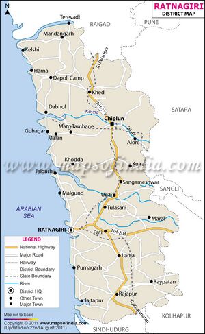
The district is bounded by the Arabian Sea to the west, Sindhudurg district to the south, Raigad district to the north and Satara, Sangli and Kolhapur districts to the east.This district is part of Konkan division.
History
From pre-Christian times until 1312, the area - like the entire region - was ruled by various Buddhist and Hindu rulers. The first state known by name was the Maurya Empire, the last non-Muslim dynasty were the Yadavas of Devagiri.
After decades of military clashes with Muslim rulers in northern India, it was occupied by Muslim armies between 1312 and 1470. From 1500 on there was fierce fighting for rule on the coast between the Muslim rulers and the Portuguese. After that, various Muslim dynasties ruled until 1658 (Sultanate of Delhi, Bahmani, Deccan Sultanates and the Mughals). From 1658 most of the area became part of the Maratha Empire. After the defeat of the Marathas against the British in 1818, Ratnagiri area became an administrative region of the Bombay Presidency . [1]
With the independence of India in 1947 and the reorganization of the country, it became part of the new state of Bombay State in 1950. In 1948 the district grew through the incorporation of the Sawantwadi princely state. In 1960, Bombay State was divided and the area became part of the newly created state of Maharashtra. In 1981 the district was divided and the southern part of the district became Sindhudurg district.[2]
Mention by Xuanzang
Xuanzang, the noted Chinese Buddhist monk, mentioned this region in his book as Konkana Desha; Varahamihira's Brihat-Samhita described Konkan as a region of India; and 15th century author Ratnakosh mentioned the word Konkandesha.[3] Ratnagiri district falls in the northern section of this land.
Administrative divisions
Ratnagiri district has nine talukas or subdivisions, namely Ratnagiri, Rajapur, Lanja, Sangameshwar,Chiplun, Guhagar, Kher, Dapoli and Mandangarh.
Parshuram Legend
According to the Sahyadrikhanda of the Skanda Purana, Parashurama threw his axe into the sea and commanded the Sea God to recede up to the point where his axe landed. The new piece of land thus recovered came to be known as Saptah-Konkana, meaning "piece of earth", "corner of earth", or "piece of corner", derived from Sanskrit words: koṇa (कोण, corner) + kaṇa (कण, piece).[4][5]
रत्नागिरि जिला
रत्नागिरि जिला भारत के राज्य महाराष्ट्र के पैंतीस जिलों में से एक है। रत्नागिरि जिले का मुख्यालय और प्रमुख शहर है। जिले के पश्चिम में अरब सागर, दक्षिण में सिंधुदुर्ग जिला, उत्तर में रायगढ़ जिला और पूर्व में सतारा सांगली और कोल्हापुर जिले स्थित हैं। यह जिला कोंकण मंडल का भाग है।
External links
References
- ↑ Census GIS India
- ↑ Greater Bombay District Gazetteer 1960, Ancient Period, pp. 127–163
- ↑ Saradesāya, Manohararāya (2000). "The Land, the People and the Language". A History of Konkani Literature: From 1500 to 1992. Sahitya Akademi. pp. 1–14. ISBN 8172016646.
- ↑ Shastri Gaytonde, Gajanan (ed.). Shree Scanda Puran (Sayadri Khandha) (in Marathi). Mumbai: Shree Katyani Publication.History
- ↑ Satoskar, B. D. Gomantak Prakruti ani Sanskruti. Part 1 (in Marathi). Shubhada Publication. p. 206.

