Bharuch

Bharuch (Hindi: भड़ूच),Gujarati: ભરૂચ) (Baroch) is a district in Gujarat in India.
Variants
It was known to history by various names such as Bharakuccha, Bhrigu Kaksha (the domain of Bhrigu, an ancient Indian sage), Bhroach, as well as Bhrauch. Bharuch was called by the name of Barygaza by Greeks/Romans. During the British Raj it was officially known as Broach.
Jaina sources write it as Bhrigukachchha (भृगुकच्छ). This ancient port-city was associated with Jainism since pre-Christian times.As early as 2nd century AD two Buddhist monks were defeated in a debate by a shvetambar monk called Jinadeva, at this place. [1]
Location
Tahsils in Bharuch district
History
Excavations near the banks of the river Narmada in Bharuch have revealed many archeological and architectural wonders, mostly temples. Later Bharuch was part of the Mauryan Empire (322–185 BC), the Western Satraps, the Guptas and the Gurjars. According to historical accounts, the kingdom with capital at Bhinmal (or Srimal) was established by the Gurjars (or Gujjars).The kingdom of Bharuch was the offshoot of this Kingdom.
Mention by Periplus

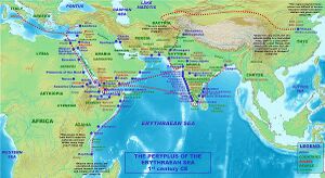
Bharuch was called by the name of Barygaza by Greeks/Romans. North India also traded with western and southern nations via Ujjain and Bharuch. Trade with the Indian harbour of Barygaza is described extensively in the Periplus. Nahapana, ruler of the Indo-Scythian Western Satraps is mentioned under the name Nambanus,[2]as ruler of the area around Barigaza:
- 41. "Beyond the gulf of Baraca is that of Barygaza and the coast of the country of Ariaca, which is the beginning of the Kingdom of Nambanus and of all India. That part of it lying inland and adjoining Scythia is called Abiria, but the coast is called Syrastrene. It is a fertile country, yielding wheat and rice and sesame oil and clarified butter, cotton and the Indian cloths made therefrom, of the coarser sorts. Very many cattle are pastured there, and the men are of great stature and black in color. The metropolis of this country is Minnagara, from which much cotton cloth is brought down to Barygaza."
- —Periplus of the Erythraean Sea, Chap. 41[10]
Broach dynasty of the Chauhans

- Reference - This sectionis mainly from "Early Chauhan Dynasties" by Dasharatha Sharma, pp. 15-19
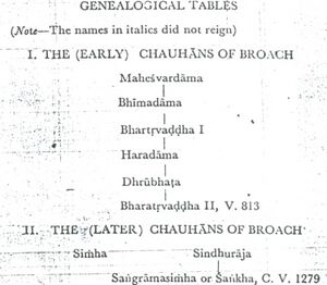
To the Chauhans of Broach belongs the earliest of the Chauhan inscriptions discovered so far, viz., the Hansot Plates of V. 813=756 A.D. which refer themselves to the reign of the illustrious Nagavaloka and record the gift of a village in the Akruresvaravishaya (modern Ankalesvar taluka) by Bhartrivaddha II, the Chauhan chief of Bhrigukachchha.
The donor's genealogy has been given as follows:-
In the Chauhan family:-
- Rajan Maheshvaradama (राजन महेश्वरदाम)
- ↓
- Bhimadama (भीमदाम)
- ↓
- Bhartrivaddha (I) (भर्तृवड़्ढा I)
- ↓
- Paramamaheshvara Haradama (परममहेश्वर हरदाम)
- ↓
- Dhru bhatadeva (ध्रुभटदेव)
- Paramamaheshvara-samadhigatapanchamahashabda-mahasamantadhipati
- ↓
- Bhartrivaddha ( II) (भर्तृवड़्ढा II)
It is obvious from the donor's titles that he was a feudatory of Nagavaloka (Nagabhata I of the Imperial Prathihara dynasty) to whose reign the grant has been referred. That the termination avaloka was not confined to the Rashtrakutas is shown by Nagabhata II of the Imperial Pratihara dynasty being called Nagavaloka in the Pratihari inscription of Parabala (EI, IX. pp. 252ff) and the Harsha inscription of Vigraharaja II of Shakambhari and in the Prabhavakacharita (p.109 of Nirnayasagar Edition, Bombay). The five members of Bhartrvaddha II's family, who preceded him, have been given a good deal of conventional praise. But as the first of them bears merely the colourless title rajan and the others do not enjoy even this distinction, they probably were no more than petty chieftain. Broach, at least, could not have been under them, for we find the Gurjara ruler Jayabhata III ruling there up to 736 A.D. Bhartrivaddha II was, probably, the first Chauhan ruler of Lata, and his rise to power was, in all likelihood, due to the incursions of Junaid, the Governor of Sind under Caliph Hisham (724-743 A.D.), whose armies are known to have raided Broach, and advanced even further to the south towards Nausari where their further progress was barred by strong Chalukya forces led by Avanijanasraya Pulakeshin of Lata. The Arabs retired from there. But we hear no more after this of the Gurjara kingdom of Broach. Its place was taken, perhaps, immediately, or shortly after, by the principality founded by the Chauhan chief Bhartrivaddha II who is believed to have been related in some way or other to the rulers of Valabhi and was, one might reasonably feel sure, helped in rising to this new dignity by his overlord Nagabhata I, the Gwalior inscription of whose descendant Mihira Bhoja [EI XVIII, pp. 107ff.] describes him (Nagabhata I) as a defeater of the big army of the lord of Mlechchhas.[Ibid., Verse-4] The destruction of the Gurjara kingdom of Broach took place somewhere between 736 A.D., the last date known for Jayaabhata III, and 738 A.D., the year of Pulakeshin's Nausari grant mentioned above. Bhartrivaddha II's principality must, therefore, have come into existence between this slightly uncertain date and 756 A.D., the year of the Hansot Plates. Tammim, the successor of Junaid, is known to have been a weak Governor during whose time the Arabs had to retire from many places that they had previously occupied. Broach was obviously one of the places they had to be evacuated. We have no information about the successors of Bhartrivaddha II. Probably the dynasty ended with him, because within one year of his Hansot Plates we find the Rashtrakuta Governor Kakka II granting lands to a brahmana from Jambusar which is not more than 25 miles or so from Bhrigukachchha. The Ellora Dashavatara inscription ascribes some victories in Lata to Dantidurga, the founder of the Rashtrakuta line of the Deccan. As he was a contemporary of Bhartrivaddha II, both the establishment of the governorship of Kakka Rashtrakuta in Gujarat and the disappearance of the Lata kingdom of the Chauhans within the short period intervening between the Hansot and Antroli-Chharoli grants may be ascribed to the brilliant military achievements of Dantidurga.
Later Chauhans of Bhrigukachha.
Nearly four centuries later, we once more come across a Chauhan dynasty ruling in this tract with its headquarters at Broach. A little before V. 1279, the important port of Cambay also had belonged to it. It had been in the bhukti of the Sindhuraja, the younger brother of Simha, the Chauhan ruler of Broach, and had been captured by Lavanyaprasada Vaghela of Dholka as the result of a battle in which the Chauhan forces had been decisively beaten. And then closely in the wake of this event had followed another defeat. Simhana, the Yadava ruler of Devagiri, slew Sindhuraja on the banks of the Narmada and put his son Sankha into captivity. But for the help of their erstwhile enemy Lavanyaprasada who not liking any increase in the power of his rival Simhana came to the Chauhans' rescue while their professed ally Devapala of Malwa hung back for sheer fear, Bhrgukachchha and its adjoining territories would have passed into the hands of the Yadavas. This act of political generosity turned Simha, the Chauhan ruler of Broach, into a friend of Lavanyaprasada. But Simha does not appear to have lived long after this event. About V. 1280, he was succeeded by his nephew Sankha who had been released from Yadava captivity with a view, perhaps, to fomenting trouble against Chalukyas.
Jayatsimha Sankha probably lost Broach soon after his second fight for we find it being ruled in V. 1298-1241 A.D. by Vastupala's nephew Lavanyasimha. The Broach dynasty of the Chauhans thus most probably ended with Sankha. Sankha was a well-known warrior and obviously a good diplomat. His attacks on the Vaghelas were well-timed, though they miscarried, because he had insufficient resources at his command and could not, with his position as a mahamandelaleshvara, direct the policy of stronger and more influential rulers like Devapala. His was not, at least, an inglorious failure.
The relationship between the family of Sankha and Bhartrivaddha II is unknown. But it is not unlikely, as surmised by Dr. H.C. Ray, that they might have been related, for both are known to have belonged to Broach.
Visit by Xuanzang in 640 AD
Alexander Cunningham[3] writes that
In the seventh century the district of Po-lu-kie-che-po, or Barukachwa, was from 2400 to 2500 li, or from 400 to 417 miles, in circuit; and its chief city was on the bank of the Nai-mo-tho, or Narmmada river, and close to the sea. With these data it is easy to identify
[p.327]: the capital with the well-known seaport town of Bharoch, under its Sanskrit name of Bhrigu-Kachha as written by the Brahmans, or Bharukachha as found in the old inscriptions. The latter was no doubt the more usual form, as it is almost literally preserved in the ΒαρύΎαξα of Ptolomy, and the 'Periplus'. From Hwen Thsang's measurement of its circuit, the limits of the district may be determined approximately as extending from the Mahi[4] river on the north, to Daman on the south, and from the Gulf of Khambay on the west to the Sahyadari mountains on the east.
According to the text of Hwen Thsang, Bharoch and Balabhi were in Southern India, and Surashtra in "Western India ; but as he places Malwa in Southern India, and Ujain in Central India, I look upon these assignments as so many additional proofs of the confusion which I have already noticed in the narrative of his travels in Western India. I would therefore assign both Balabhi and Bharroch to Western India, as they formed part of the great province of Surashtra. The correctness of this assignment is confirmed by the author of the 'Periplus,' who notes that below Barygaza the coast turns to the south, whence that region is named Dakhinabades, as the natives call the south Dakhanos.[5]
Notable persons
External links
References
- ↑ Encyclopaedia of Jainism, Volume-1 By Indo-European Jain Research Foundation p.5510
- ↑ Anjali Desai, India Guide Gujarat, India Guide Publications, 2007, page 160, ISBN 978-0-9789517-0-2
- ↑ The Ancient Geography of India: I. The Buddhist Period, Including the Campaigns of Alexander, and the Travels of Hwen-Thsang. By Sir Alexander Cunningham, p.326-327
- ↑ The Mais river of Ptolemy.
- ↑ Peripl. Mar. Erythr., in Hudson's Geogr, Vet., i. 20i
Back to Gujarat

