Barabhum
| Author:Laxman Burdak, IFS (R) |


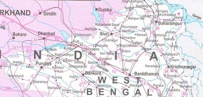
Barabhum is a city in Barabazar community development block of Purulia Sadar West subdivision of Purulia district in the Indian state of West Bengal. Barabazar police station serves this block. Headquarters of this block is at Barabhum. Barabazar is an urban area in this block.[1]
Location
Barabhum is located at 23°05′30″N 86°12′42″E.
Jat clan
History
Jaina Bhagavati-Sutra of 5th century AD mentions that Purulia was one of the sixteen mahajanapadas and was a part of the kingdom known as Vajra-bhumi in ancient times.
Kirana Suvarna was one of Buddhist Kingdoms visited by Xuanzang in 639 AD. Kirana Suvarna has been identified with Barabhum in Purulia district of West Bengal by Alexander Cunningham[2]
Alexander Cunningham[3] writes that Hwen Thsang places the capital of Kie-lo-na-su-fa-la-na, or Kirana Suvarna, at 700 li, or 117 miles, to the north-west of Tamralipti, and the same distance to the north-east of Odra or Orissa.[4] As the capital of
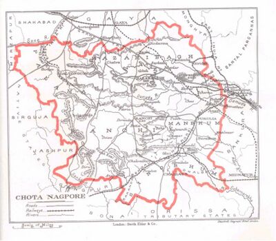
[p.505]: Orissa in the seventh century was Jajipur on the Vaitarani river, the chief city of Kirana Suvarna must be looked for along the course of the Suvarna-riksha river (Subarnarekha), somewhere about the districts of Singhbhum and Barabhum. But this wild part of India is so little known that I am unable to suggest any particular place as the probable representative of the ancient capital of the country. Bara Bazar is the chief town in Barabhum, and as its position corresponds very closely with that indicated by Hwen Thsang, it may be accepted as the approximate site of the capital in the seventh century. The territory was from 4400 to 4500 li, or from 733 to 750 miles, in circuit. It must, therefore, have comprised all the petty hill- states lying between Medinipur and Sirguja on the east and west, and between the sources of the Damuda and Vaitarani on the north and south.
This large tract of country is now occupied by a number of wild tribes who are best known by the collective name of Kolhan or Kols. But as the people themselves speak various dialects of two distinct languages, it would appear that they must belong to two different races, of whom the Munda and the Uraon may be taken as the typical representatives. According to Colonel Dalton,[5] "the Mundas first occupied the country and had been long settled there when the Uraons made their appearance;" and "though these races are now found in many parts of the country occupying the same villages, cultivating the same fields, celebrating together the same festivals and enjoying the same amusements, they are of totally distinct origin, and cannot intermarry without loss of caste." This
[p.506]: difference of race is confirmed by the decisive test of language, which shows that the Uraons are connected with the Tamilian races of the south, while the Mundas belong to the hill men of the north, who are spread over the Himalayan and Vindhyan mountains from the Indus to the Bay of Bengal.
The various tribes connected with the Mundas are enumerated by Colonel Dalton[6] as the Kuars of Elichpur, the Korewas of Sirguja and Jaspur, the Kherias of Chutia Nagpur, the Hor of Singhbhum, the Bhumij of Manbhum and Dhalbhum, and the Santals of Manbhum, Singhbhum, Katak, Hazaribagh, and the Bhagalpur hills. To these he adds the Juangas or Pattuns (leaf-clad) of Keunjar, etc. in the Kataka tributary districts, who are isolated from " all other branches of the Munda family, and have not themselves the least notion of their connection with them ; but their language shows that they are of the same race, and that their nearest kinsmen are the Kherias. The western branches of this race are the Bhils of Malwa and Kanhdes, and the Kolis of Gujarat. To the south of these tribes there is another division of the same race, who are called Suras or Suars. They occupy the northern end of the eastern Ghats.
In 1833, Manbhum district was carved out of Jungle Mahals district, with headquarters at Manbazar. In 1838, the headquarters was transferred to Purulia.
In 1956, Manbhum district was partitioned between Bihar and West Bengal under the States Reorganization Act and the Bihar and West Bengal (Transfer of Territories) Act 1956. The district was very large in size and included parts of Bankura, Burdwan of present West Bengal and Dhanbad, Dhalbhum, Saraikela and Kharswan of present states of Jharkhand and Orissa. [7]
Gram panchayats
Gram panchayats of Barabazar block/panchayat samiti are: Baghbandh, Banjora, Bansbera, Barabazar, Berada, Dhelat-Bamu, Latpada, Sindri, Sukurhutu and Tumrasole.
External links
References
- ↑ "Contact details of Block Development Officers". Purulia district. West Bengal Governmen
- ↑ The Ancient Geography of India/Eastern India, p.505
- ↑ The Ancient Geography of India/Eastern India, p.505
- ↑ Julien 's 'Hiouen Thsang,' iii.84 and 88. See Map No. I.
- ↑ Journ. Asiat. Soc. Bengal, 1866, p. 154.
- ↑ Journ. Asiat. Soc. Bengal, 1866, 158. I write Santal in preference to Sonthal, as I believe that the short o is only the peculiar Bengali pronunciation of the long ā.
- ↑ "Historical background" from Official Website of Purulia District.
Back to West Bengal

