Bhima River
| Author:Laxman Burdak, IFS (R) |

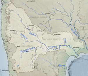
Bhima River (भीमा नदी), also called Bhimarathi (भीमरथी नदी), is a major river in Western India and South India. It flows southeast for 861 km through Maharashtra, Karnataka, and Telangana states, before entering the Krishna River.
The river is also referred to as Chandrabhaga River, especially at Pandharpur, as it resembles the shape of the Moon. Bhima river also flows from Daund taluka.
Origin

It originates near Bhimashankar Temple in the Bhimashankar hills in khed Taluka on the western side of the Western Ghats, known as Sahyadri, in Pune District, Maharashtra state.
Variants
- Bhima River भीमा नदी (AS, p.672)
- Bhimarathi River भीमरथी नदी AS, p.672)
Course
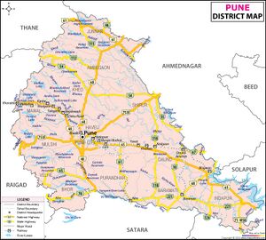
The Bhima River flows southeast for a long journey of 861 kilometres (535 mi), with many smaller rivers as tributaries. It originates near Bhimashankar Temple in the Bhimashankar hills in khed Taluka on the western side of the Western Ghats, known as Sahyadri, in Pune District, Maharashtra state,
It flows through Bhimashankar Wildlife Sanctuary where it enters Khed Taluka and is soon joined by its tributary, the Aria River from the right (west) which flows into the Chas Kaman Reservoir. From there it is 8 km along the river to the railroad bridge at the town of Rajgurunagar (Khed) on the left bank. In 18 km further along the river, the Bhima River enters from the right just above the village of Pimpalgaon on the left bank. From there to Siddhegavhan along the river is 10 km. Siddhegavhan is the last village in Khed Taluka on the left.
After leaving Khed Taluka, the Bhima forms the boundary between Havali Taluka on the right (south) and Shirur Taluka on the left (north). From the Bhima's intersection to the Indrayani River, which also enters from the right, is 14 km along the river. At the confluence is the town of Tulapur on the right bank in Havali Taluka. The Bhima River, the Indrayani River and the Mula-Mutha River are the major tributaries of the Bhima that drain western Pune. After the Indrayani, in about 4 km down stream the Dhomal River enters from the right, at the village of Wadhu Budruk. Shortly thereafter (3.5 km) the Bhima passes under the SH 60 bridge at the town of Koregaon Bhima. From Koregaon going east, downstream 16 km, is the confluence with the Vel River (Wel River) from the left (north) and the village of Vittalwadi. The Vel River also arises in Ambegaon Taluka, east of the Bhima, and flows through Khed Taluka and into Shirur Taluka before flowing into the Bhima. With Vittalwadi on the left, the right side of the river leaves Haveli Taluka and enters Daund Taluka.
From Vittalwadi the Bhima meanders northwest and 14 km after the Vel River enters from the left, the Kamania River (Kamina) enters from the left at the village of Parodi. After the Kamania River enters, the river meanders back southeast for 23 km to the confluence with the Mula-Mutha River from the right] at the village of Ranjangaon Sandas. The Mula-Mutha River flows from the city of Pune where it is a combination of the Mula River and the Mutha River.
31 km after the Mula-Mutha River, the Ghod River enters from the left (north) across the Bhima from the village of Nanvij (Nanwij). The Ghod River is the last of the Western Ghat tributaries of the Bhima. Shirur Taluka stops at the Ghod River, and Shrigonda Taluka of Ahmednagar District continues on the left (northeast) side of the river. Downstream just 6 km from the Ghod River, is the city of Daund on the right (southwest) bank.
Chandani, Kamini, Moshi, Bori, Sina, Man, Bhogavati river and Nira are the major tributaries of the river in Solapur District. Of these, the Nira river meets with the Bhima between Nira Narsingpur in Pune District and Malshiras Taluka in Solapur district.
Bhima merges into the Krishna along the border between Karnataka and Telangana about 24 km north of Raichur. At the point where the two rivers meet, the Bhima is actually longer than the Krishna in length. [1]
Tributaries
- Sina River
- Nira River
- Mula-Mutha River
- Chandani River
- Kamini River
- Kukadi River
- Man River
- Bhogavati river
- Indrayani River
- Ghod River
- Bhama River
- Pavana River
- Kagna River
- Benitura River
In Mahabharata
Bhima River (भीमा) is mentioned in Mahabharata (VI.10.21)
Bhimarathi River (भीमरथी) is mentioned in Mahabharata (III.86.3)
Bhisma Parva, Mahabharata/Book VI Chapter 10 describes geography and provinces of Bharatavarsha. Bhima River (भीमा) is mentioned in Mahabharata (VI.10.21).[2].... of Purvabhirama, and Vira (Nira), and Bhima, and Oghavati; of Palashini (Pashashini), and Papahara, and Mahendra, and Patalavati,....
Vana Parva, Mahabharata/Book III Chapter 86 mentions the sacred tirthas of the south. Bhimarathi River (भीमरथी) is mentioned in Mahabharata (III.86.3).[3]....In that quarter lieth the sacred and auspicious river Godavari (गॊदावरी) (III.86.2), full of water abounding in groves and frequented by ascetics. In that direction also are the rivers Venna (वेण्णा) (III.86.3) and Bhimarathi (भीम रथी) (III.86.3), both capable of destroying sin and fear, and abounding in birds and deer, and graced with abodes of ascetics.
भीमरथी
विजयेन्द्र कुमार माथुर[4] ने लेख किया है ...1. भीमरथी नदी AS, p.672)= भीमा नदी 'वेणा भीमरथी चैव नद्यौ पापभयापहे, मृगद्विजसमाकीर्णे तापसालय- भूषिते' (महाभारत वन पर्व 88,3) अर्थात् वेणा और भीमरथी नदियाँ समस्त पापभय को नाश करने वाली हैं। इनके तट पर मृगों और द्विजों का निवास है तथा तपस्वियों के आश्रम हैं।
भीमरथी, कृष्णा नदी की सहायक नदी भीमा नदी है. उपर्युक्त उद्धरण में पांडवों के पुरोहित धौम्य ने दक्षिण दिशा के तीर्थों के संबंध में इस नदी का उल्लेख किया है. भीष्म. 9,20 में भी भीमरथी का उल्लेख है- 'शरावतीं पयोष्णों च वेणी भीमरथीमपि'। विष्णु पुराण 2,3,12 में भीमरथी को सह्याद्रि से उद्भूत कहा गया है- 'गोदावरीभीमरथामपि कृष्णवेष्यादिकास्तथा सह्यपादोद्भूता: नद्य: स्मृता: पापभयापहा:'। सह्याद्रि पश्चिमी घाट की पर्वत-श्रेणी का नाम है। श्रीमद्भागवत 5,19,18 में भीमरथी का वेण्या ओर गोदावरी के साथ उल्लेख है- 'तुंगभद्रा कृष्णा वेष्या भीमरथी गोदावरी।
2. भीमरथी नदी AS, p.672) = महाराष्ट्र की चंद्रभागा नदी जिसके तट पर प्रसिद्ध तीर्थ पंढरपुर स्थित है. यह सह्याद्री से निकलकर कृष्णा नदी में मिल जाती है. संभवत: महाभारत भीष्म पर्व 9,22 में इसी का उल्लेख है--'पूर्वाभिरामां वीरां च भीमाम ओघवतीं तदा, पलाशिनीं पापहरां महेन्द्रां पाटलावतीम्'. भीमरथी का उल्लेख इसी संदर्भ में 9,20 में है जिससे इन दोनों की भिन्नता सूचित होती है.
भीमा नदी परिचय
भीमा नदी भारत की एक नदी है। भीमा नदी, कृष्णा नदी की प्रमुख सहायक नदी है। इस नदी को भीमरथी नदी के नाम से भी जाना जाता है। यह महाराष्ट्र और कर्नाटक राज्यों से होकर बहती है। इसका उद्गम पश्चिमी घाट की भीमशंकर पर्वतश्रेणी से होता है और यह महाराष्ट्र में 725 किमी दक्षिण-पूर्व की ओर बहने के बाद कर्नाटक में कृष्णा नदी से जा मिलती है। इसकी प्रमुख सहायक नदियाँ सीना और नीरा हैं। भीमा अपवाह क्षेत्र पश्चिमी घाट (पश्चिम), बालाघाट पर्वतश्रेणी (उत्तर) और महादेव पर्वतश्रेणी (दक्षिण) से सीमांकित है।
भीमा नदी गहरी खाइयों से होकर गुज़रती है और इसके तट सघन अबादी वाले हैं। इसका जल स्तर मौसमी परिवर्तनों पर निर्भर करता है। बाढ़ का पानी अपने पीछे उपजाऊ जलोढ़ मिट्टी छोड़ जाता है। उजाणी में हाल में निर्मित बांध से सिंचाई द्वारा कृषि को राहत मिली है और निचले इलाक़े में बाढ़ का ख़तरा कम हुआ है। वर्षा के बिखरे हुए जल को संग्रहीत कर स्थानीय स्तर पर सिंचाई की जाती है। इससे प्रमुख फ़सलें ज्वार, बाजरा और तिलहन की सिंचाई की जाती है। सिंचित क्षेत्र से प्राप्त गन्ना एक महत्त्वपूर्ण नक़दी फ़सल है।
भीमशंकर
विजयेन्द्र कुमार माथुर[5] ने लेख किया है ...भीमशंकर (AS, p.672): महाराष्ट्र में मुंबई से पूर्व की ओर 70 मील तथा पुणे से उत्तर की ओर 43 मील पर भीमाशंकर का मंदिर स्थित है जिसकी गणना द्वादश ज्योतिर्लिंगों में की जाती है. यह भीमा नदी के तट पर और सह्याद्री पर्वत पर स्थित है. पुराणों में इस मंदिर की स्थिति डाकिनी ग्राम में मानी है ('डाकिन्यां भीमशंकरम्'). भीम नदी भीमशंकर पर्वत से ही निकलती है. भीमशंकर पर्वत सह्याद्री का एक शिखर है.
External links
References
- ↑ "Bhima River Pushkaralu 2018 Ghats in Telangana". Trip Trees. Trip Trees.
- ↑ पूर्वाभिरामां वीरां च भीमाम ओघवतीं तदा, पलाशिनीं पापहरां महेन्द्रं पिप्पलावतीम (VI.10.21)
- ↑ वेण्णा भीम रथी चॊभे नद्यौ पापभयापहे, मृगद्विजसमाकीर्णे तापसालयभूषिते (III.86.3)
- ↑ Aitihasik Sthanavali by Vijayendra Kumar Mathur, p.672
- ↑ Aitihasik Sthanavali by Vijayendra Kumar Mathur, p.672
Back to Rivers

