Kulpa Balaghat
| Author:Laxman Burdak, IFS (R) |


Kulpa (कुल्पा) is a village in Lanji tahsil in Balaghat district of Madhya Pradesh.
Variants
- Kollapūraka/ Kollapuraka(कोल्लपूरक) mentioned in Siwani Plates of 18th year of Pravarasena II[1] = Kulpa (कुल्पा). Kulpa (कुल्पा) is a village in Lanji tahsil in Balaghat district of Madhya Pradesh.
Location
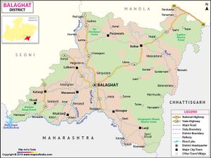
Kulpa is situated in the border of Madhya Pradesh and Maharashtra. Kulpa is 25 km from sub-district headquarters and 84 km from District headquarters.
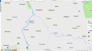
Kulpa is a Village in Lanji Tehsil in Balaghat District of Madhya Pradesh State, India. It is located 62 KM towards South from District head quarters Balaghat. 17 KM from Lanji. Kulpa Pin code is 481224 and postal head office is Karanja (Balaghat). Karanja ( 3 KM ) , Bapadi ( 4 KM ) , Singola ( 6 KM ) , Miriya ( 8 KM ) , Dahegaon ( 8 KM ) are the nearby Villages to Kulpa. Kulpa is surrounded by Salekasa Tehsil towards South , Lanji Tehsil towards North , Goregaon Tehsil towards west , Gondia Tehsil towards west.[2]
Jat Gotras Namesake
History
Siwani Plates of 18th year of Pravarasena II[3] record the grant, by Pravarasena II, of the village Brahmapūraka (ब्रह्मपूरक) to the Brahmana Devaśarmāchārya of the Maudgalya gotra. (p.28)
The donated village, Brahmapūraka (ब्रह्मपूरक), was situated in the Beṇṇākarpara-bhoga (वेण्णाकरपर-भोग) and lay to the north of Vaṭpūraka (वटपूरक), to the west of Kiṇihikheṭaka (किणिहिखेटक), to the south of Pavarajjavātaka (प्रवरज्जवाटक) and to the east of Kollapūraka (कोल्लपूरक) . The village adjoining it was named Karañjaviraka (करञ्जविरक). The grant was made on the 12th tithi of the bright fortnight of Phalguna in the eighteenth regnal year (expressed in words) of Pravarasena II. The Senapati at the time was Bāppadeva. The charter was written by Acharya.
The localities mentioned in the present plates remained unidentified for a long time. Altekar identified Brahmapuraka (ब्रह्मपूरक) with Brahmanwada (ब्राहमणवाडा) near Achalpur. This is incorrect as none of the other villages can be identified in the vicinity of Brahmanwada.
Identification by Vasudev Vishnu Mirashi: Vasudev Vishnu Mirashi[4] has identified the localities mentioned as under:
- Karanja (करंजा), about 6 miles from Amgaon, a railway station on the Calcutta-Nagpur line of the South-Eastern Railway, is probably the ancient Karanjaviraka (करञ्जविरक).
- Brahmapuraka (ब्रह्मपूरक), the donated village, is Bamhani (बमहनी), about three miles from Karanja.
- Kollapūraka (कोल्लपूरक) of the plates is now represented by Kulpa near Karanja, about 5 miles to the west of Bamhani.
- Pavarajjavātaka (प्रवरज्जवाटक) and Vatapuraka (वटपूरक) may be the modern Paraswada and Badgaon near Bamhani6. These places lie within 20 to 30 miles from the eastern bank of the Wainganga and were in all probability included in the Bennakarpara-bhoga mentioned in the present plates. (p.29)
Identification by Author (Laxman Burdak): Author (Laxman Burdak) has identified these places as under:
- Brahmapuraka/ Brahmapūraka (ब्रह्मपूरक) mentioned in Siwani Plates of 18th year of Pravarasena II[5] = Bamhani (बम्हनी). Bamhani (बम्हनी) is a village in Kirnapur tahsil in Balaghat district of Madhya Pradesh. It is located on eastern bank of Wainganga River.
- Beṇṇākarpara-bhoga/Bennakarparabhoga (वेण्णाकरपर-भोग) mentioned in Siwani Plates of 18th year of Pravarasena II[6] = Beni (बेणी). Beni (बेणी) is a historical village in Khairlanji tahsil in Balaghat district of Madhya Pradesh. It is situated on Wainganga River near the border of Maharashtra.
- Vaṭpūraka/Vatpuraka (वटपूरक) mentioned in Siwani Plates of 18th year of Pravarasena II[7] = Badgaon. Badgaon is a village in Lanji tahsil in Balaghat district of Madhya Pradesh.
- Kiṇihikheṭaka/Kinihikhetaka (किणिहिखेटक) mentioned in Siwani Plates of 18th year of Pravarasena II[8] = Kinhi (किन्ही). Kinhi (किन्ही) is a village in Kirnapur tahsil in Balaghat district of Madhya Pradesh. It is situated on the eastern bank of Bagh River, a tributary of Wainganga.
- Pavarajjavātaka (प्रवरज्जवाटक) mentioned in Siwani Plates of 18th year of Pravarasena II[9] = Paraswada (परसवाड़ा). Paraswada (परसवाड़ा) is a village in Lanji tahsil in Balaghat district of Madhya Pradesh.
- Karañjaviraka/Karanjaviraka (करञ्जविरक) mentioned in Siwani Plates of 18th year of Pravarasena II[10] = Karanja (करंजा). Karanja (करंजा) is a village in Lanji tahsil in Balaghat district of Madhya Pradesh.
Notable persons
Gallery
Population
External links
References
- ↑ Corpus Inscriptionum Indicarum Vol.5 (inscriptions Of The Vakatakas), Edited by Vasudev Vishnu Mirashi, 1963, Archaeological Survey of India, p.28-32
- ↑ https://www.onefivenine.com/india/villages/Balaghat/Lanji/Kulpa
- ↑ Corpus Inscriptionum Indicarum Vol.5 (inscriptions Of The Vakatakas), Edited by Vasudev Vishnu Mirashi, 1963, Archaeological Survey of India, p.28-32
- ↑ Corpus Inscriptionum Indicarum Vol.5 (inscriptions Of The Vakatakas), Edited by Vasudev Vishnu Mirashi, 1963, Archaeological Survey of India, p.28-32
- ↑ Corpus Inscriptionum Indicarum Vol.5 (inscriptions Of The Vakatakas), Edited by Vasudev Vishnu Mirashi, 1963, Archaeological Survey of India, p.28-32
- ↑ Corpus Inscriptionum Indicarum Vol.5 (inscriptions Of The Vakatakas), Edited by Vasudev Vishnu Mirashi, 1963, Archaeological Survey of India, p.28-32
- ↑ Corpus Inscriptionum Indicarum Vol.5 (inscriptions Of The Vakatakas), Edited by Vasudev Vishnu Mirashi, 1963, Archaeological Survey of India, p.28-32
- ↑ Corpus Inscriptionum Indicarum Vol.5 (inscriptions Of The Vakatakas), Edited by Vasudev Vishnu Mirashi, 1963, Archaeological Survey of India, p.28-32
- ↑ Corpus Inscriptionum Indicarum Vol.5 (inscriptions Of The Vakatakas), Edited by Vasudev Vishnu Mirashi, 1963, Archaeological Survey of India, p.28-32
- ↑ Corpus Inscriptionum Indicarum Vol.5 (inscriptions Of The Vakatakas), Edited by Vasudev Vishnu Mirashi, 1963, Archaeological Survey of India, p.28-32

