Pishin

Pishin is a small town and District of Balochistan province, Pakistan.
Location
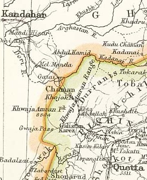
Pishin is located in the northwest of Balochistan, in the east of the province near the border with Afghanistan. Pishin connects Quetta, the provincial capital, to Afghanistan. It is considered part of the Pashtun belt of Balochistan, and it is the largest district of Pashtun tribes in the region. Due to its high population and vast area, a new tehsil, Huramzai, has been established, and Malikyar is popular place/village for its greenery and production of different kinds of fruits and vegetables. and beautiful lake Band Khushdil Khan is present in Malikyar.
Origin of name
The name Pishin is a modernized form of ‘Pushang’, which is how the city was designated in (mainly pre-modern) Persian sources (Arabic sources using 'Fushang'). Myth attributes the origin of the Persian designation to a son of the mythical Emperor Afrasiab. Fushing was the spelling used in the records of the Afghan government.
History
H. W. Bellew[1] writes....The Tarin tribe occupies the Sibi and Peshin districts, and is one of the five tribes composing the Sharkhbun division of the Sarabanri Afghan. ....The Tor Tarin, "Black Tarin," inhabit the Peshin valley, having the Achakzi to their north, the Barech to their west, and the district of Shal (Quetta) to their south, whilst on the east they are separated from their Spin Tarin tribesmen by a strip of Kakar territory.
H. W. Bellew[2] writes ....Hakalon stands for Hykalan, or people of the village in Peshin valley of Kalat Balochistan, now called Hykalzi, and they probably represent the Aiglai of Herodotus (twelfth satrapy).
H. W. Bellew[3] writes that ....The eastern part of the Ghilzi country, at the head waters of the Tarnak and Arghasan rivers, is a rich pasture tract in the summer season, whilst the open plain and steppe to the westward affords good winter quarters in the sheltered hollows of the undulating surface. This country was the first real and permanent settlement of the Ghilji in Afghanistan, and during the early centimes of the Muhammadan era was known by the name of Turan probably, from the name of the combined clans just as at the same period, the country to the south, including the present Peshin and Shal or Quetta, was called Budha from the Budhists inhabiting it.
In 1975 it was separated from Quetta district for administrative reasons. Pishin was founded by the British Empire in 1883.[4] It played a role in the Anglo-Afghan Wars. Local tribes from the area assisted Baran Khan Tareen in fighting the British by attacking British military convoys en route to Afghanistan. During World War II, the British built two air bases in the district; one near the town of Pishin and the other in Saranan.
Visit by Xuanzang in 644 AD
Alexander Cunningham[5] writes about Falana or Banu, a District in the Khyber Pakhtunkhwa Province of Pakistan. The name of Fa-la-na is mentioned only by Hwen Thsang, who places the country to the south-east of Ghazni, and at fifteen days' journey to the south of Lamghan.[6]
[p.86]:Hwen Thsang mentions a district on the western frontier of Falana, named Ki-kiang-na, the position of which has not yet been fixed. M. Vivien de St. Martin and Sir H. Elliot have identified it with the Kaikanan, or Kikan, of the Arab historians of Sindh ;[7] but unfortunately the position of Kaikanan itself is still undetermined. It is, however, described as lying to the north or north-east of Kachh Gandava, and as Kikiangna was to the west of Falana or Banu, it appears probable that the district intended must be somewhere in the vicinity of Pishin and Kwetta ; and as Hwen Thsang describes it as situated in a valley under a high mountain, I am inclined to identify it with the valley of Pishin itself, which lies between the Khoja Amran hills on the north, and the lofty Mount Takatu on the south. This position agrees with that of Kaikan, <arabic> given by Biladuri,[8] who says that it formed part of Sindh in the direction of Khorasan. This is further confirmed by the statement that Kaikan was on the road from Multan to Kabul, as the usual route between these places lies over the
[p.87]: Sakhi Sarwar Pass in the Sulimani mountains, and across the Pishin valley to Kandahar. A shorter, but more difficult, route is by the valley of the Gomal river to Ghazni. But as the valley of the Gomal belonged to Falana, it follows that the district of Kikiangna must have been somewhere in the neighbourhood of Pishin; and as this valley is now inhabited by the tribe of Khakas, it is not improbable that the name of Kikan, or Kaikan, may have been derived from them.
Administration
The district of Pishin is administratively subdivided into four tehsils: and one sub Tehsil:
People
Pishin's main ethnic groups are Tareen. Syed, Kakar, and Achakzai. Other tribes include Durrani, Barakzai, Khiral, Ghilzai. In the city the majority of the population belongs to Tareen tribe, followed by Syed and then Kakar. Several Christian families also live there.
Tribes - Pishin District is home to several tribes but following Four main tribes form the major population of the district:[9] Tareen, Sayed, Kakar, Achakzai
Notable persons
External links
References
- ↑ An Inquiry Into the Ethnography of Afghanistan,p.139
- ↑ An Inquiry Into the Ethnography of Afghanistan,p.122
- ↑ The Races of Afghanistan/Chapter XI,p.100-101
- ↑ Encyclopedia Britannica. Encyclopedia Britannica Online.
- ↑ The Ancient Geography of India/Udyana, pp. 84-87
- ↑ H. Th., i. 265.
- ↑ ' Hiouen Thsang,' iii. 185 ; Dowson's edition of Sir H. Elliot's ' Muhammadan Historians,' i. 381.
- ↑ Reinaud's 'Fragments Arabes, etc.,' p. 184.
- ↑ [1]
Back to Jat Places in Pakistan

