Arakan
| Author: Laxman Burdak IFS (R) |


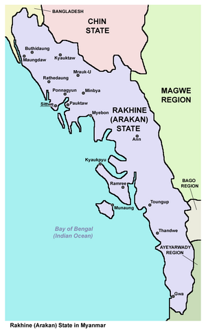
Arakan (अराकान) is a historic coastal region in Southeast Asia. The region now forms the Rakhine State in Myanmar, earlier Burma.
Variants of name
- Arakan (अराकान) दे. Tamrapattana (ताम्रपट्टन) (AS, p.38)
- Argyré (Claudius Ptolemy )
- Arracao (Portuguese records)
- Araccan (Europeans)
- Rakhaing (Burmese tradition)
- Rohang (Arab traders)
- Tamrapattana ताम्रपट्टन (AS, p.394) - Tamrapattana (Burma) was the capital of first Hindu ruler of Brahmadesha, Dharmarajanuvansha, who ruled for 300-400 years over the region. Probably Arakan country was Tamrapattana.[1]
Location
It borders faced the Bay of Bengal to its west, the Indian subcontinent to its north and Burma proper to its east. The Arakan Mountains isolated the region and made it accessible only by sea.
Etymology
Claudius Ptolemy identified Arakan as Argyré.[2] Portuguese records spelled the name as Arracao.[3] The name was spelled as Araccan in many old European maps and publications.[4] The region was named as Arakan Division during British rule in Burma.
Early Arab traders were familiar with the Indian name of Rohang as the name of Arakan.[5] Burmese tradition holds the name of the region to be Rakhaing.[6]
History
The first inhabitants of Arakan are likely to be the Tibeto-Burman people, who today make up the region's majority. Given its proximity to the Indian subcontinent, Indo-Aryan speaking peoples have been present in Arakan since antiquity. Arakan became one of the earliest regions in Southeast Asia to embrace Dharmic religions, particularly Buddhism and Hinduism. Islam arrived with Arab traders in the 8th century. From the 15th century, Islamic influence grew during Arakan's vassalage to the Bengal Sultanate. The Kingdom of Mrauk U emerged as an independent Arakanese kingdom for 300 years. During the Age of Discovery, Arakan caught the interest of the Dutch East India Company and the Portuguese Empire. Arakan became a center of piracy and other areas of commerce.
Early inhabitants: It is unclear who the earliest inhabitants were; some historians believe the earliest settlers included the Burmese Mro tribe but there is a lack of evidence and no clear tradition of their origin or written records of their history.[7] Burmese traditional history holds that Arakan was inhabited by the Rakhine since 3000 BCE. But there is no archaeological evidence to support the claim.[8] According to British historian Daniel George Edward Hall, who wrote extensively on the history of Burma, "The Burmese do not seem to have settled in Arakan until possibly as late as the tenth century AD. Hence earlier dynasties are thought to have been Indian, ruling over a population similar to that of Bengal. All the capitals known to history have been in the north near modern Akyab".[9]
Ancient Indic influence: Arakan came under strong Indic influence from the Indian subcontinent, particularly the ancient kingdoms of the Ganges delta. Arakan was one of the first regions in Southeast Asia to adopt Dharmic religions. It became one of the earliest Indianized kingdoms in Southeast Asia. Buddhist missionaries from the Mauryan Empire traveled through Arakan to other parts of Southeast Asia.[10][11]
First states: Due to the evidence of Sanskrit inscriptions found in the region, historians believe the founders of the first Arakanese state were Indian.[12] The first Arakanese state flourished in Dhanyawadi between the 4th and 6th centuries. The city was the center of a large trade network linked to India, China and Persia.[13] Power then shifted to the city of Waithali, where the Chandra dynasty ruled. Waithali became a wealthy trading port.[14] The Chandra-ruled Harikela state was known as the Kingdom of Ruhmi to the Arabs.[15]
Arrival of Islam: Since in the 8th century, Arab merchants began conducting missionary activities, and many locals converted to Islam.[16] Some researchers have speculated that Muslims used trade routes in the region to travel to India and China.[17] A southern branch of the Silk Road connected India, Burma and China since the neolithic period.[18][19] Many Arab merchants married local women and settled in Arakan. As a result of intermarriage and conversion, the Muslim population in Arakan grew.[20]
Rakhine migration: It is also unclear that the Rakhine people were one of the tribes of the Burmese Pyu city-states because Pyus are not related with Burmese ethnic. They began migrating to Arakan through the Arakan Mountains in the 9th century. The Rakhines settled in the valley of the Lemro River. Their cities included Sambawak I, Pyinsa, Parein, Hkrit, Sambawak II, Myohaung, Toungoo and Launggret. The cities flourished between the 11th and 15th centuries. The Burmese invaded Arakan in 1406.[21]
Indian Origin Places in Burma
Dineschandra Sircar[22] writes.... Among Sanskrit-Pali names in Burma, mention may be made of Golanagara or Golamrittikanagara (modern Ayetthema, 20 miles north of Thaton, Gola being supposed to stand for Gauda[23] Kalasapura (to the south eat of Prome near the mouth of Sittang,[24] Ramapura (Moulmein), Ramanyadesh (Lowe Burma)[25] and Shri (Bhamo or Tagaung).[26]. The principalities of Pushkaravati, Trihakumbha, Asitanjana and Ramyanagara were situated in the region of Rangoon, Ramavati and Dhanyavati (modern Rakhaingmyu being situated in Arakan[27] The city of Shrikshetra has been located at Hmawza near Prome. Sudharmapura is modern Thaton and the city of Arimardanapura is Pagan situated in the land of Tattadesha and the kingdom of Tamradvipa [28]
अराकान परिचय
अराकान बर्मा का एक प्रदेश है। अराकान की पट्टी बंगाल की खाड़ी के पूर्वी तट पर स्थित है। यहाँ 1784 ई. तक एक स्वतंत्र राज्य रहा था, जिसे बर्मी लोगों ने जीत लिया था। बर्मा की सीमा के विस्तार से भारत की अंग्रेज़ ब्रिटिश सरकार ने बंगाल के लिए ख़तरा महसूस किया। प्रथम बर्मा युद्ध (1824-1826) का एक कारण यह भी था। युद्ध के बाद अराकान का क्षेत्र 'यन्दबू की सन्धि' के अनुसार भारत की अंग्रेज़ी सरकार को मिल गया।
बंगाल की खाड़ी के पूर्वी तट पर चटगांव (चिटागांग) से नेग्रेस अंतरीप तक अराकान विस्तृत है। इस प्रकार इसकी लंबाई लगभग 400 मील है। इसकी चौड़ाई उत्तर में 90 मील है, परंतु अराकान योमा पर्वत के कारण दक्षिण की ओर अराकान की चौड़ाई धीरे-धीरे कम होते-होते 15 मील (लगभग 24 कि.मी.) हो जाती है। तट पर अनेक टापू हैं। इस प्रदेश का प्रधान नगर 'अकयाब' है। प्रांत चार ज़िलों में विभक्त है। अराकान का क्षेत्रफल लगभग 16,000 वर्ग मील है। भौगोलिक दशा
अराकान की चार मुख्य नदियाँ- नाफ, मायू, कलदन और लेमरो हैं। कलदन काफ़ी गहरी नदी है और इसमें छोटे जहाज 50 मील (लगभग 80 कि.मी.) भीतर तक जा सकते हैं अन्य नदियाँ बहुत छोटी हैं, क्योंकि वे पहाड़ जिनसे ये निकली हैं, समुद्र के निकट हैं। पर्वत को पार करने के लिए कई दर्रे हैं।
अराकान में निवास करने वालों की सभ्यता अति प्राचीन है। मान्यता के अनुसार 2,666 ई.पू. से आज तक के सभी राजाओं के नाम ज्ञात हैं। कभी मुग़ल और कभी पुर्तग़ाली लोगों ने कुछ भागों पर अधिकार जमा लिया था, परंतु वे जल्द ही पराजित कर दिये गए। सन 1826 से यहाँ अंग्रेज़ों का शासन रहा था। जनवरी, सन 1948 से बर्मा पुन: स्वतंत्र हो गया और अब वहाँ गणतंत्र राज्य है।
अराकान का प्रधान नगर पहले अराकान था, परंतु अस्वास्थ्यप्रद होने के कारण अब यहाँ का 'अक्याब नगर' प्रधान नगर हो गया है। हालाँकि अराकान के निवासी मुख्यत: बर्मी है तो भी यहाँ के रीति और रिवाजों में काफ़ी अंतर है। यहाँ बहुत बड़ी संख्या में बौद्ध धर्म के अनुयायी हैं।
अराकान का प्रदेश पहाड़ी है और केवल दशम भू-भाग में ही खेती हो पाती है। अराकान की मुख्य फ़सल धान है। फल, तंबाकू, मिर्च आदि की भी यहाँ खेती होती है। अराकान में वन क्षेत्रफल भी अधिक है, लेकिन परंतु वर्षा बहुत (औसतन 120 से 130 तक) होती है।
संदर्भ: अराकान
ताम्रपट्टन
ताम्रपट्टन (AS, p.394): बर्मा का एक प्राचीन नगर था। इस नगर में ब्रह्मदेश के प्रथम हिन्दू राज्यवंश 'धर्मराजानुवंश' की राजधानी थी। इस वंश के शासकों ने यहाँ के प्रदेश पर 300-400 वर्षों तक राज्य किया था। संभव है कि पूरे अराकान प्रदेश को ही ताम्रपट्टन कहा जाता हो।[29]
Jat History
Hukum Singh Panwar (Pauria)[30] writes .... When the Saka people moved still further in the far eastern countries, they founded a city named Vaisali[31] in Burma, which became the capital of Arakan, ruled over by the Hindu dynasty of
The Jats:Their Origin, Antiquity and Migrations: End of p.196
Dhanyawati from 8th century AD. to 11th century A.D., and which is now identified with Vaithali village, surrounded by monuments ancient Vaisali. It is further interesting to note that the ancient Kambuja[32] (modern Cambodia and Cochin-China, or Kampuchia Kambojia, Thailand-Dahiland?) and Ayuthya = Ayodhya, which was made capital by a chief of Utong, who assumed the title of Ramadhipat in 1350 A.D. in Siam (Thailand or Dahiland) are unmistakably reminicent of the migrations and settlements of the Sakas, Kambojas and probably Manvas (Manns) [33] also in those countries in olden times[34] (For ancient Indian Literature in Java and Bali islands, see Weber, 1914; 189 195, 208,229, 271, 280). Jitra or Jatra, a place name in the plains of Malaya, may well be attributed to the old Saka Jats (Mall or Malli from ancient Malloi) in that peninsula, probably known as Malaya after them.
Jats at Arakan front

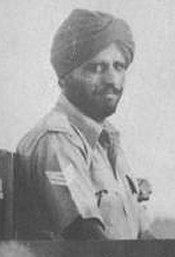
Major Prakash Singh VC (31 March 1913 – 23 March 1991) was a Jat Sikh recipient of the Victoria Cross. During the Second World War, Singh was a 28 year old Havildar serving in the Bren Gun Carrier Platoon of 5th Battalion 8th Punjab Regiment, British Indian Army (now 5th Battalion The Baloch Regiment of Pakistan Army). In January 1943, his battalion was engaged in fighting on the Mayu Peninsula in the Arakan, Burma, against Japanese forces.
R S Joon[35] writes that his Battalion was fighting along the Coast of Arakan. In a battle, the MG battalion which was with them suffered very heavy casualties. A number of carriers were abandoned with wounded British soldiers still inside. These were under heavy enemy fire and could not be recovered. Maj. Prakash Singh went forward on a truck. When fire came, the British driver of the truck ran away. Single handed and regardless of the bullets, Prakash Singh started collecting the causalities which included a British Officer. When he was pulling a carrier with the chain, he saw a company of the enemy advancing towards him. He un-clamped an M M G from the carrier and fired. The company stopped coming. Later, 70 dead were counted. Prakash Singh brought back all the wounded. A British General happened to see all this. Prakash Singh was awarded the Victoria Cross.

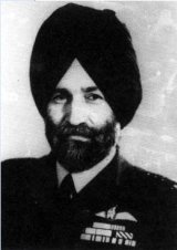
Arjan Singh Aulakh Marshal of the Air Force Arjan Singh Aulakh DFC. (b:15-4-1919. d: 16-9-2017) was the only officer of the Indian Air Force who was given a Five Star General's rank; equal to a Field Marshal.[36] He led No.1 Squadron, Indian Air Force into command during the Arakan Campaign in 1944. He was awarded the Distinguished Flying Cross (DFC) in 1944, and commanded the Indian Air Force Exhibition Flight in 1945.
Lance Naik Karam Singh VC - In 1944, the unit was detailed to fight with the Japanese on the Arakan front. Karam Singh got the long cherished opportunity to display his dash and strength. He risked his life on a number of occasions while fighting with the Japanese on the Htinshbyin, Buthidaung and Manipur fronts. He was wounded as many as four times in the Burma campaign. For his outstanding feats of bravery, Karam Singh was invested with the coveted Military Medal on March 14, 1944. He was subsequently promoted to the rank of Lance Naik.
References
- ↑ Aitihasik Sthanavali by Vijayendra Kumar Mathur, p.394
- ↑ Arthur Purves Phayre (1883). History of Burma. Рипол Классик. p. 42. ISBN 978-5-87742-763-1.
- ↑ Frederick Charles Danvers (1988). The Portuguese in India: Being a History of the Rise and Decline of Their Eastern Empire. Asian Educational Services. p. 528. ISBN 978-81-206-0391-2.
- ↑ A New, Royal, and Authentic System of Universal Geography...,p.247.
- ↑ Abū al-Faz̤l ʻIzzatī; A. Ezzati (2002). The Spread of Islam: The Contributing Factors. ICAS Press. p. 482. ISBN 978-1-904063-01-8.
- ↑ Arthur P. Phayre (17 June 2013). History of Burma: From the Earliest Time to the End of the First War with British India. Routledge. p. 41. ISBN 978-1-136-39848-3.
- ↑ Beniison, J.J (1933). Census of India, 1931: Burma Part I – Report. Rangoon: Office of Superintendent, Government Printing and Stationery, Burma. p. 149.
- ↑ William J. Topich; Keith A. Leitich (9 January 2013). The History of Myanmar. ABC-CLIO. ISBN 978-0-313-35725-1.,p:17
- ↑ D. G. E Hall, A History of South East Asia, New York, 1968, P. 389.
- ↑ British Academy (4 December 2003). Proceedings of the British Academy, Volume 121, 2002 Lectures. OUP/British Academy. p. 76. ISBN 978-0-19-726303-7.
- ↑ "Vaishali and the Indianization of Arakan - Noel F. Singer - Google Books". Books.google.com.bd. 1980-11-24.
- ↑ William J. Topich; Keith A. Leitich (9 January 2013). The History of Myanmar. ABC-CLIO. ISBN 978-0-313-35725-1,p:17
- ↑ William J. Topich; Keith A. Leitich (9 January 2013). The History of Myanmar. ABC-CLIO. ISBN 978-0-313-35725-1,p:18
- ↑ William J. Topich; Keith A. Leitich (9 January 2013). The History of Myanmar. ABC-CLIO. ISBN 978-0-313-35725-1,p:18
- ↑ "Harikela - Banglapedia". En.banglapedia.org.
- ↑ Sunil S. Amrith (7 October 2013). Crossing the Bay of Bengal. Harvard University Press. p. 37. ISBN 978-0-674-72846-2.
- ↑ "The thoroughfare of Islam - Dhaka Tribune". www.dhakatribune.com.
- ↑ Foster Stockwell (30 December 2002). Westerners in China: A History of Exploration and Trade, Ancient Times through the Present. McFarland. p. 15. ISBN 978-0-7864-8189-7.
- ↑ Fuxi Gan (2009). Ancient Glass Research Along the Silk Road. World Scientific. p. 70. ISBN 978-981-283-357-0.
- ↑ Andrew T. H. Tan (2009). A Handbook of Terrorism and Insurgency in Southeast Asia. Edward Elgar Publishing. p. 327.
- ↑ William J. Topich; Keith A. Leitich (9 January 2013). The History of Myanmar. ABC-CLIO. ISBN 978-0-313-35725-1.,p:18–20
- ↑ Studies in the Geography of Ancient and Medieval India, By Dineschandra Sircar, p.319
- ↑ ibid.,p.195
- ↑ ibid.,p.197
- ↑ ibid.,p.196
- ↑ ibid.,p.200
- ↑ Coedes, The Indianised States in South-East Asia,p.329,cf p.156, RC Majumdar,opcit,p.202
- ↑ RC Majumdar,opcit,p.207
- ↑ Aitihasik Sthanavali by Vijayendra Kumar Mathur, p.394
- ↑ The Jats:Their Origin, Antiquity and Migrations/The Scythic origin of the Jats, p.196-197
- ↑ Mathur op.cit., p. 883. Radha Kumud Mukerji, Anc.Ind. Allahabad, 1966, pp. 489f
- ↑ Radha Kumud Mukerji, op.cit., p. 492.
- ↑ Ibid. Mathur, op.cit., p. 37. Takakusu, A record of the Buddhist Religion as practised in Ind. and the Malay Archipelago, Delhi, 1966, p. 41. Chaturvedi, Vimalkant: Bankok City of Buddha Temples. in 'The Suman Sauram' (Hind i), Jhandewala Estate, Rani Jhansi Marg, New Delhi, May 1988, p. 49. The city was destroyed by the Burmese army.
- ↑ Ency. America, No, 28, p.107. about 100,000 Indians [of Jat tribes of Dahiya (Dahae) and Mann?) migrated to Vietnam in prehistoric time. (within brackets mine).
- ↑ R S Joon:History of the Jats/Chapter XIII,p.229
- ↑ Marshal of the Air Force Arjan Singh, DFC

