Karakoram
| Authors: Dayanand Deswal & Laxman Burdak, IFS (R) |


Karakoram (काराकोरम पर्वतमाला) is a large mountain range spanning the borders of India, and China, with the northwest extremity of the range extending to Afghanistan and Tajikistan.
Variants
- Krishnagiri (कृष्णगिरि पहाड़ी) (AS, p.220)
- Karakorum
- Karakuram
Location
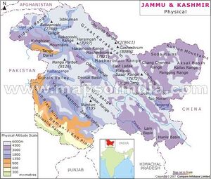
It is located in the regions of Gilgit–Baltistan (now in illegal occupation of Pakistan), Ladakh (India), and southern Xinjiang (China), and reaches the Wakhan Corridor (Afghanistan). A part of the complex of ranges from the Hindu Kush to the Himalayan Range, it is one of the Greater Ranges of Asia. The Karakoram is home to the four most closely located peaks over 8000m in height on earth: K2, the second highest peak in the world at 8,611 m (28,251 ft), Gasherbrum I, Broad Peak and Gasherbrum II.
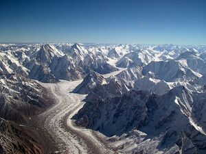
The Karakoram range is about 500 km (311 mi) in length, and is the most heavily glaciated part of the world outside the polar regions. The Siachen Glacier at 76 kilometres and the Biafo Glacier at 63 kilometres rank as the world's second and third longest glaciers outside the polar regions.
Rivers
The Karakoram area is the origin of several rivers emanating from the Himalayas, the largest being the Indus River.
Yarkand river originates in the Karakoram range in the south of the Kashgar Prefecture.
Jat clans
- Kurmi (कुर्मी) [1] Koormi (कुर्मी)[2] is gotra of Jats in Uttar Pradesh. They were the people dwelling in area around Karakoram and known as Kurmi.[3]
Karakoram Highway
The N-35 or National Highway 35, known more popularly as the Karakoram Highway and China-Pakistan Friendship Highway, is a 1300-km long national highway in Pakistan which extends from Hasan Abdal in Punjab province of Pakistan to the Khunjerab Pass in Gilgit-Baltistan, where it crosses into China and becomes China National Highway 314. The highway connects the Pakistani provinces of Punjab, Khyber Pakhtunkhwa and Gilgit-Baltistan with China's Xinjiang Uyghur Autonomous Region.
The highway has been the bone of contention between India and Pakistan, as it crosses through the western Kashmir region, which is in illegal occupation of Pakistan. Pakistan calls this area Azad Kashmir and India calls it Pakistan Occupied Kashmir (POK).
कृष्णगिरि
विजयेन्द्र कुमार माथुर[4] ने लेख किया है ...2. कृष्णगिरि पहाड़ी (AS, p.220) = हिंदुकुश से लगा हुआ काराकोरम पहाड़. कृष्णगिरि का वायु पुराण 36 में वर्णन है.
काराकोरम पर्वतमाला
काराकोरम एक विशाल पर्वत श्रृंखला है जिसका विस्तार पाकिस्तान के गिलगित-बल्तिस्तान, भारत में लद्दाख और चीन के झिंजियांग क्षेत्रों तक फैला हुआ है। यह एशिया की विशाल पर्वतमालाओं में से एक है और हिमालय पर्वतमाला में से एक है और हिमालय पर्वतमाला का एक हिस्सा है।
विश्व के किसी भी स्थान के मुकाबले काराकोरम पर्वतमाला में 5 मील से भी ऊंची लगभग 60 चोटियां स्थित हैं जिनमें दुनिया की दूसरी सबसे ऊंची चोटी के-2 भी शामिल है। के-2 की ऊंचाई विश्व के सर्वोच्च शिखर एवरेस्ट से केवल 237 मीटर कम है।
काराकोरम शृंखला का विस्तार 500 किमी तक फैला हुआ है और ध्रुवीय क्षेत्रों को छोड़कर दुनिया के सबसे अधिक हिमनद इसी इलाके में हैं। ध्रुवीय क्षेत्रों से बाहर सियाचिन ग्लेशियर 70 किमी और बिआफो ग्लेशियर 63 कि. मी. की लम्बाई के साथ दुनिया के दूसरे और तीसरे सबसे लंबे हिमनद हैं।
काराकोरम पूर्वोत्तर में तिब्बती पठार के किनारे और उत्तर में पामीर पर्वतों से घिरा है। काराकोरम की दक्षिणी सीमा, पश्चिम से पूर्व गिलगित, सिंधु और श्योक नदियों से बनती है जो इसे पश्चिमोत्तर हिमालय शृंखला के अंतिम किनारे से अलग कर दक्षिण-पश्चिम दिशा में पाकिस्तान के मैदानी इलाकों की ओर बहती है।
Also See
External Links
References
- ↑ Dr Ompal Singh Tugania: Jat Samuday ke Pramukh Adhar Bindu, p.32,sn-337.
- ↑ Jat History Dalip Singh Ahlawat/Parishisht-I, s.n. क-119
- ↑ Mahendra Singh Arya et al.: Adhunik Jat Itihas, Agra 1998,
- ↑ Aitihasik Sthanavali by Vijayendra Kumar Mathur, p.220

