Sogdiana
| Author: Laxman Burdak, IFS (R). |


Sogdiana (सोग्डिआना = सुग्ध) was the ancient civilization of an Iranian people and a province of the Achaemenid Empire. The Samarkand city was known by an abbreviated name of Marakanda when Alexander the Great took it in 332 BC. At that time Maracanda was the capital of the land of the Sogdianians.[1]
Variants of name
- Sogdiana and Sogdianians (Anabasis by Arrian,p. 155, 199-206, 215, 235-240, 284, 378.)
- Sogdians (Anabasis by Arrian,p. 341.)
- Sughdha (सुग्ध): Sanskrit name Ramanaka (रमणक) or Rochaka (रोचक), Greek Sogdiana (सोग्डियाना), present Samarkand city of Uzbekistan.[2].
- Sugdha सुग्ध (AS, p.972)
- Sogdia
- Suguda (Old Persian)
- Sogdiana
- Sogdianian
- Sogdianians
- Σογδιανή (Ancient Greek),
- Sogdianē
- Soġd (Persian)
- Tajik: Суғд, سغد Suġd;
- Uzbek: Sơģd;
- Chinese: 粟特 Sùtè)
- Sogdiani (Pliny.vi.18)
Jat Gotras Namesake
Jat Gotras Namesake
- Sogaria = Sogdiana and Sogdianians (Anabasis by Arrian,p. 155, 199-206, 215, 235-240, 284, 378.)
- Sogaria = Sogdians (Anabasis by Arrian,p. 341.)
Jat clan
- Sogaria
- Solanki: P.C. Bagchi in, “India and Central Asia” says that the Sulikas are originally from Sogdiana in Central Asia, and came to settle in India. [3]
History
It is eighteenth in the list on the Behistun Inscription of Darius the Great (i. 16). Sogdiana is "listed" as the second of the "good lands and countries" that Ahura Mazda created. This region is listed second after Airyanem Vaejah, "homeland of the Aryans", in the Zoroastrian book of Vendidad, indicating the importance of this region from ancient times.[4] Sogdiana, at different times, included territories around Samarkand, Bukhara, Khujand, Panjikent and Shahrisabz in modern Tajikistan and Uzbekistan.
The inhabitants of Sogdiana were the Sogdians, an Eastern Iranian people who are among the ancestors of modern-day Tajik, Pashun and Yaghnobi peoples.
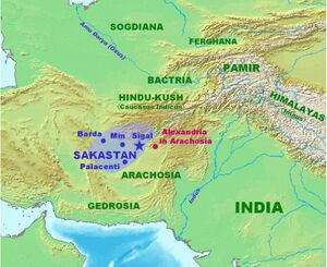
The Sogdian states, although never politically united, were centered around the main city of Samarkand. Sogdiana lay north of Bactria, east of Khwarezm, and southeast of Kangju between the Oxus (Amu Darya) and the Jaxartes (Syr Darya), embracing the fertile valley of the Zeravshan (ancient Polytimetus). Sogdian territory corresponds to the modern provinces of Samarkand and Bokhara in modern Uzbekistan as well as the Sughd province of modern Tajikistan.
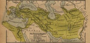
An independent and warlike Sogdiana[5] formed a border region insulating the Achaemenid Persians from the nomadic Scythians to the north and east. The Sogdian Rock or Rock of Ariamazes, a fortress in Sogdiana, was captured in 327 BC by the forces of Alexander the Great; after an extended campaign putting down Sogdian resistance and founding military outposts manned by his Macedonian veterans, Alexander united Sogdiana with Bactria into one satrapy. The military power of the Sogdians never recovered. Subsequently Sogdiana formed part of the Hellenistic Greco-Bactrian Kingdom, founded in 248 BC by Diodotus, for about a century. Euthydemus I seems to have held the Sogdian territory, and his coins were later copied locally. Eucratides apparently recovered sovereignty of Sogdia temporarily. Finally the area was occupied by nomads when the Scythians and Yuezhis overran it around 150 BC.
सुग्ध
सुग्ध (AS, p.972): बुखारा और समरकंद के प्रदेश का, जिसमें वर्तमान अफगानिस्तान का उत्तरी तथा रूस का दक्षिणी भाग सम्मिलित है, प्राचीन भारतीय नाम है.[6]
सुग्ध (सोग्डिआना) (गणराज्य)
एक बृहदभारतीय जनपद (सिकंदर आक्रमणकालीन - उत्तर पश्चिम भारतीय लोकसमूह एवं गणराज्य) जो दक्षिण अफगाणिस्तान में सीर नदी के प्रदेश में बसा हुआ था । सिकंदर के आक्रमण के समय, इस देश में ईरानी एवं भारतीय दोनों प्रकार के आर्यौं की वस्तियाँ एवं नगरराज्य थे ।[7]
तुखारिस्तान
तुखारिस्तान - दलीप सिंह अहलावत लिखते हैं - यह देश तुखार या तुषार वंशज जाट के नाम पर प्रसिद्ध था। इसकी स्थिति भारतवर्ष और ईरान के बीच में थी। सुग्ध, कम्बोज और बल्ख प्रदेश इसके अन्तर्गत थे। इस तुखारिस्तान देश की राजधानी तेरमिज थी। यह तुषारों का देश गिलगित तक था। इनके नाम पर तुषारगिरि पर्वत था जो मुस्लिमकाल में हिन्दुकुश के नाम से प्रसिद्ध हुआ। इन लोगों ने अपनी तुखारी भाषा भी प्रचलित की थी। (देखो तृतीय अध्याय, ऋषिक-तुषार-मलिक प्रकरण)।[8]
जाट इतिहास
डॉ रणजीतसिंह[9] लिखते हैं....जाटों के विस्तार की पुष्टि एंटीक्विटी ऑफ जाट रेस के लेखक उजागर सिंह महल के विचारों से भी होती है। महल महोदय अपनी पुस्तक में लिखते हैं - "मैं अब विशालतम जाट साम्राज्य का वर्णन करता हूं जो कि मात्र भौगोलिक सीमाओं के कारण ही बड़ा नहीं था, अपितु इजिप्ट और असीरिया के साम्राज्यों से भी बड़ा था। यह स्मरण रखना चाहिए कि पर्शियन साम्राज्य जाट साम्राज्य की देन है और पर्शियन राजाओं में जाट रक्त विद्यमान है। जाटों के इस साम्राज्य को मेड़ा साम्राज्य कहते हैं[10] महल के मतानुसार जाटों ने रोमन साम्राज्य, स्पेन और ब्रिटेन तक को जीता था [11] [पृष्ठ.5]: इससे आगे वे लिखते हैं ....:"यूरोप की डेन्यूब नदी जाटों के पुरातात्विक इतिहास की दृष्टि से बड़ी महत्वपूर्ण है। इस नदी के दोनों किनारों पर जाट ही निवास करते थे। डेन्यूब नदी जाटों से इतनी संबंधित है कि वह उनके स्वप्नों में भी आती है।"
सिकंदर महान ने अपने एशिया आक्रमण के समय सोगड़ियाना (तुर्किस्तान) पर आक्रमण किया था। उस समय सोगड़ियाना की राजधानी समरकंद थी। उजागर सिंह के विचार अनुसार यह प्रदेश उस समय जाटों के अधीन था जो कि पंजाब के जाटों के बहुत दूर के पूर्वज थे।
Mention by Pliny
Pliny[12] mentions 'Nations situated around the Hyrcanian Sea'... Beyond it are the Sogdiani,24 the town of Panda, and, at the very extremity of their territory, Alexandria,25 founded by Alexander the Great. At this spot are the altars which were raised by Hercules and Father Liber, as also by Cyrus, Semiramis, and Alexander; for the expeditions of all these conquerors stopped short at this region, bounded as it is by the river Jaxartes, by the Scythians known as the Silis, and by Alexander and his officers supposed to have been the Tanais. This river was crossed by Demodamas, a general of kings Seleucus and Antiochus, and whose account more particularly we have here followed. He also consecrated certain altars here to Apollo Didymæus.26
24 D'Anville says that there is still the valley of Al Sogd, in Tartary, beyond the Oxus. The district called Sogdiana was probably composed of parts of modern Turkistan and Bokhara. The site of Panda does not appear to be known.
25 It was built on the Jaxartes, to mark the furthest point reached by Alexander in his Scythian expedition. It has been suggested that the modern Kokend may possibly occupy its site.
26 The "twin," of the same birth with Diana.
Ch.8 Description of Darius-III's Army at Arbela against Alexander

They come to the aid of Darius-III (the last king of the Achaemenid Empire of Persia) and were part of alliance in the battle of Gaugamela (331 BC) formed by Darius-III in war against Alexander the Great at Arbela, now known as Arbil, which is the capital of Kurdistan Region in northern Iraq.
Arrian[13] writes....Alexander therefore took the royal squadron of cavalry, and one squadron of the Companions, together with the Paeonian scouts, and marched with all speed; having ordered the rest of his army to follow at leisure. The Persian cavalry, seeing Alexander, advancing quickly, began to flee with all their might. Though he pressed close upon them in pursuit, most of them escaped; but a few, whose horses were fatigued by the flight, were slain, others were taken prisoners, horses and all. From these they ascertained that Darius with a large force was not far off. For the Indians who were conterminous with the Bactrians, as also the Bactrians themselves and the Sogdianians had come to the aid of Darius, all being under the command of Bessus, the viceroy of the land of Bactria. They were accompanied by the Sacians, a Scythian tribe belonging to the Scythians who dwell in Asia.[1] These were not subject to Bessus, but were in alliance with Darius. They were commanded by Mavaces, and were horse-bowmen. Barsaentes, the viceroy of Arachotia, led the Arachotians[2] and the men who were called mountaineer Indians. Satibarzanes, the viceroy of Areia, led the Areians,[3] as did Phrataphernes the Parthians, Hyrcanians, and Tapurians,[4] all of whom were horsemen. Atropates commanded the Medes, with whom were arrayed the Cadusians, Albanians, and Sacesinians.[5] The men who dwelt near the Red Sea[6] were marshalled by Ocondobates, Ariobarzanes, and Otanes. The Uxians and Susianians[7] acknowledged Oxathres son of Aboulites as their leader, and the Babylonians were commanded by Boupares. The Carians who had been deported into central Asia, and the Sitacenians[8] had been placed in the same ranks as the Babylonians. The Armenians were commanded by Orontes and Mithraustes, and the Cappadocians by Ariaoes. The Syrians from the vale between Lebanon and Anti-Lebanon (i.e. Coele-Syria) and the men of Syria which lies between the rivers[9] were led by Mazaeus. The whole army of Darius was said to contain 40,000 cavalry, 1,000,000 infantry, and 200 scythe-bearing chariots.[10] There were only a few elephants, about fifteen in number, belonging to the Indians who live this side of the Indus.[11] With these forces Darius had encamped at Gaugamela, near the river Bumodus, about 600 stades distant from the city of Arbela, in a district everywhere level;[12] for whatever ground thereabouts was unlevel and unfit for the evolutions of cavalry, had long before been levelled by the Persians, and made fit for the easy rolling of chariots and for the galloping of horses. For there were some who persuaded Darius that he had forsooth got the worst of it in the battle fought at Issus, from the narrowness of the battle-field; and this he was easily induced to believe.
1. Cf. Aelian (Varia Historia, xii. 38).
2. Arachosia comprised what is now the south-east part of Afghanistan and the north-east part of Beloochistan.
3. Aria comprised the west and north-west part of Afghanistan and the east part of Khorasan.
4. Parthia is the modern Khorasan. Hyrcania was the country south and south-east of the Caspian Sea. The Tapurians dwelt in the north of Media, on the borders of Parthia between the Caspian passes. Cf. Ammianus, xxiii. 6.
5. The Cadusians lived south-west of the Caspian, the Albanians on the west of the same sea, in the south-east part of Georgia, and the Sacesinians in the north-east of Armenia, on the river Kur.
6. "The Red Sea was the name originally given to the whole expanse of sea to the west of India as far as Africa. The name was subsequently given to the Arabian Gulf exclusively. In Hebrew it is called Yam-Suph (Sea of Sedge, or a seaweed resembling wool). The Egyptians called it the Sea of Weeds.
7. The Uxians occupied the north-west of Persis, and Susiana was the country to the north and west of Persis.
8. The Sitacenians lived in the south of Assyria. ἐτετάχατο. is the Ionic form for τεταγμἑνοι ἦσαν.
9. The Greeks called this country Mesopotamia because it lies between the rivers Euphrates and Tigris. In the Bible it is called Paddan-Aram (the plain of Aram, which is the Hebrew name of Syria). In Gen. xlviii. 7 it is called merely Paddan, the plain. In Hos. xii. 12, it is called the field of Aram, or, as our Bible has it, the country of Syria. Elsewhere in the Bible it is called Aram-naharaim, Aram of the two rivers, which the Greeks translated Mesopotamia. It is called "the Island," by Arabian geographers.
10. Curtius (iv. 35 and 45) states that Darius had 200,000 infantry, 45,000 cavalry, and 200 scythed chariots; Diodorus (xvii. 53) says, 800,000 infantry, 200,000 cavalry, and 200 scythed chariots; Justin (xi. 12) gives 400,000 foot and 100,000 horse; and Plutarch (Alex., 31) speaks of a million of men. For the chariots cf. Xenophon (Anab., i 8, 10); Livy, xxxvii. 41.
11. This is the first instance on record of the employment of elephants in battle.
12. This river is now called Ghasir, a tributary of the Great Zab. The village Gaugamela was in the district of Assyria called Aturia, about 69 miles from the city of Arbela, now called Erbil.
Chapter xv. Voyage down the Indus to the land of Musicanus
Arrian[14] writes....THERE, at the confluence of the Acesines and Indus, he waited until Perdiccas with the army arrived, after having routed on his way the independent tribe of the Abastanians. Meantime, he was joined by other thirty-oared galleys and trading vessels which had been built for him among the Xathrians, another independent tribe of Indians who had yielded to him. From the Ossadians, who were also an independent tribe of Indians, came envoys to offer the submission of their nation. Having fixed the confluence of the Acesines and Indus as the limit of Philip’s viceroyalty, he left with him all the Thracians and as many men from the infantry regiments as appeared to him sufficient to provide for the security of the country. He then ordered a city to be founded there at the very junction of the two rivers, expecting that it would become large and famous among men.2 He also ordered a dockyard to be made there. At this time the Bactrian Oxyartes, father of his wife Roxana, came to him, to whom he gave the viceroyalty over the Parapamisadians, after dismissing the former viceroy, Tiryaspes, because he was reported to be exercising his authority improperly. Then he transported Craterus with the main body of the army and the elephants to the left bank of the river Indus, both because it seemed easier for a heavy-armed force to march along that side of the river, and the tribes dwelling near were not quite friendly. He himself sailed down to the capital of the Sogdians; where he fortified another city, made another dockyard, and repaired his shattered vessels. He appointed Peithon viceroy of the land extending from the confluence of the Indus and Acesines as far as the sea, together with all the coast-land of India. He then again despatched Craterus with his army through the country; and himself sailed down the river into the dominions of Musicanus, which was reported to be the most prosperous part of India. I-Ic advanced against this king because he had not yet come to meet him to offer the submission of himself and his land, nor had he sent envoys to seek his alliance. He had not even sent him the gifts which were suitable for a great king, or asked any favour from him. He accelerated his voyage down the river to such a degree that he succeeded in reaching the confines of the land of Musicanus before he had even heard that Alexander had started against him. Musicanus was so greatly alarmed that he went as fast as he could to meet him, bringing with him the gifts valued most highly among the Indians, and taking all his elephants. He offered to surrender both his nation and himself, at the same time acknowledging his error, which was the most effectual way with Alexander for any one to get what he requested. Accordingly for these considerations Alexander granted him an indemnity for his offences. He also granted him the privilege of ruling the city and country, both of which Alexander admired. Craterus was directed to fortify the citadel in the capital; which was done while Alexander was still present. A garrison was also placed in it, because he thought the place suitable for keeping the circumvent tribes in subjection.
External links
References
- ↑ Arrian:The Anabasis of Alexander/3b, Ch.30
- ↑ परोपकारी, अप्रेल प्रथम 2019, s.n. 2, p.6
- ↑ 160-op.cit.p.146
- ↑ AVESTA: VENDIDAD (English): Fargard 1.
- ↑ Independent Sogdiana: Lane Fox (1973, 1986:533) notes Quintus Curtius, vi.3.9: with no satrap to rule them, they were under the command of Bessus at Gaugamela, according to Arrian, iii.8.3.
- ↑ Aitihasik Sthanavali by Vijayendra Kumar Mathur, p.972
- ↑ transliteral.org
- ↑ Jat History Dalip Singh Ahlawat/Chapter IV (Page 417)
- ↑ Jat Itihas By Dr Ranjit Singh/1.Jaton Ka Vistar, pp.4-5
- ↑ एंटीक्विटी ऑफ जाट रेस, पृष्ठ 9-7 ?
- ↑ एंटीक्विटी ऑफ जाट रेस, पृष्ठ 53-66
- ↑ Natural History by Pliny Book VI/Chapter 18
- ↑ The Anabasis of Alexander/3a, Ch.8
- ↑ Arrian Anabasis Book/6b

