Gandak
| Author:Laxman Burdak, IFS (R) |


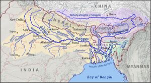
Gandak (गंडक नदी) is one of the major rivers of Nepal and a left bank tributary of the Ganges in India.
Variants
- Gandaka गंडक दे. Gandaki गण्डकी (AS, p.265)
- Gandaki गण्डकी (AS, p.265)
- Gandak River (गंडक नदी)
- Gandaki River (गंडकी नदी)
- Kali Gandaki (काली गण्डकी)
- Narayani (नारायणी)
- Narayani River (नारायणी नदी) (AS, p.494)
- Condochates /Kondochates (कोंडोचाटिज) [1]
- Condochates (Pliny.vi.22)
Course
In Nepal the river is notable for its deep gorge through the Himalayas. It has a total catchment area of 46,300 square kilometers, most of it in Nepal. The basin also contains three of the world's 14 mountains over 8,000 metres (26,000 ft), Dhaulagiri, Manaslu and Annapurna I. Dhaulagiri is the highest point of the Gandaki basin. It lies between the similar Kosi system to the east and the Karnali (Ghaghara) system to the west.
River in Nepal
In Nepal, the river quickly crosses different zones of climate Here, just 25 kms downstream from the place above, it flows through a pine forest. The Kali Gandaki river source is at the border with Tibet at an elevation of 6,268 metres at the Nhubine Himal Glacier in the Mustang region of Nepal.[2][3]
The headwaters stream on some maps is named the Chhuama Khola and then, nearing Lo Manthang, the Nhichung Khola or Choro Khola. The Kali Gandaki then flows southwest (with the name of Mustang Khola on old, outdated maps) through a sheer-sided, deep canyon before widening at the steel footbridge at Chele, where part of its flow funnels through a rock tunnel, and from this point the now wide river is called the Kali Gandaki on all maps. In Kagbeni a major tributary named Johng Khola, Kak Khola or Krishnaa descends from Muktinath.
The river then flows southward through a steep gorge known as the Kali Gandaki Gorge, or Andha Galchi, between the mountains Dhaulagiri, elevation 8,167 metres (26,795 ft) to the west and Annapurna I, elevation 8,091 metres to the east. If one measures the depth of a canyon by the difference between the river height and the heights of the highest peaks on either side, this gorge is the world's deepest. The portion of the river directly between Dhaulagiri and Annapurna I, 7 kms downstream from Tukuche), is at an elevation of 2,520 metres,[4] which is 5,571 metres lower than Annapurna I. The river is older than the Himalayas. As tectonic activity forces the mountains higher, the river has cut through the uplift.
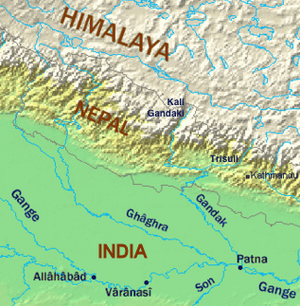
South of the gorge, the river is joined by Rahughat Khola at Galeshwor, Myagdi Khola at Beni, Modi Khola near Kushma and Badigaad at Rudrabeni above Ridi Bazaar. The river then turns east to run along the northern edge of the Mahabharat Range. The largest hydroelectricity project in Nepal is located along this stretch of the river. Turning south again and breaking through the Mahabharats, Kali Gandaki is then joined by a major tributary, the Trishuli, at Devighat,which is larger than the Kali Gandaki. Gandaki is then joined by the East Rapti River draining the Inner Terai valley known as Chitwan. The Gandaki then crosses the outermost foothills of the Himalayas—Sivalik Hills—into the Terai plains of Nepal. From Devighat, the river flows southwest of Gaindakot town. The river later curves back towards the southeast as it enters India where it is called the Gandak.
Below Gaindakot the river is known as the Narayani or Sapt Gandaki (Seven Gandakis), for seven tributaries rising in the Himalaya or further north along the main Ganges-Brahmaputra divide. These are the Kali Gandaki, the Trishuli River, and the five main tributaries of the Trishuli known as the Daraudi, Seti, Madi, Marsyandi and Budhi Gandaki.
River in India
The entry point of the river at the Indo–Nepal border is also the confluence called Triveni with rivers Pachnad and Sonha descending from Nepal. Pandai river flows into Bihar (India) from Nepal in the eastern end of the Valmiki Sanctuary and meets Masan. The Gandak flows southeast 300 kilometres across the Gangetic plain of Bihar state through West Champaran, Gopalganj, Saran and Muzaffarpur districts. It joins the Ganges near Patna just downstream of Hajipur at Sonpur (also known as Harihar Kshetra). Its drainage area in India is 7,620 square kms.
From its exit from the outermost Siwaliks foothills to the Ganges, the Gandak has built an immense megafan comprising Eastern Uttar Pradesh and North Western Bihar in the Middle Gangetic Plains. The megafan consists of sediments eroded from the rapidly uplifting Himalaya. The river's course over this structure is constantly shifting.
History
Tej Ram Sharma[5] writes the Names of Ayuktakas (Commissioners or District collectors). Damodarpur Copper-plate Inscription of the time of Budhagupta (=A.D. 476-94) mentions 5. Sa(ga)ndaka (No. 36, L. 3) :
D.C. Sircar takes the reading to be Gandaka which seems to be correct. 85 One scholar 86 equates Sandaka with Sandaka which means a 'bull' and. says that the word Gandaka yields no sensible meaning. But Gandaka has been accepted as the most probable reading by scholars.87 Gandaka is the name of a river in the northern part of India,88 So the name Gandaka based on the river Gandaki can be given to a person just as the name Ganga based on the river Ganges is given to a person. Gandaka is also the name of the Videhas living on the river Gandaki89 and also refers to a rhinoceros.90 It is possible that the present name, like Vyaghra discussed elsewhere is based on the name of an animal.
85. D.C. Sircar, Select Inscriptions. p. 337, note 1.
86. The Life of Hiuen Tsang by S. Beal. XV, p. 138.
87. R.B. Pandey, Historical and Literary Inscriptions. p. 107, note 4.
88. Sanskrit-English Dictionary by Monier Williams. p, 344, col. 2.
89. Ibid.
90. Ibid., अभिधानाचिंतामणिकोश श्लोलो. 1287 : गण्डक-गेंडा
Mention by Pliny
Pliny[6] mentions ' The Ganges.'....Some writers have stated that this river, like the Nile, takes its rise from unknown sources,1 and, in a similar manner, waters the neighbouring territory; others, again, say that it rises in the mountains of Scythia. They state also that nineteen rivers discharge their waters into it; those among them that are navigable, besides the rivers already mentioned,2 are the Condochates,3 the Erannoboas,4 the Cosoagus,5 and the Sonus.
1 So much so, indeed, that its sources were unknown to the learned world till the beginning of the present century, although the Chinese emperor Tang-Hi on one occasion sent a body of Llamas for the purpose of inquiring into the subject. It is now ascertained that the river Ganges is the result of the confluence of three separate streams, which bear the respective names of the Gannavi, the Bhagirathi, and the Alakananda. The second is of the most sacred character, and is the one to which the largest concourse of pilgrims resort. The ancients held various opinions as to the sources of the river.
2 The Cainas and the Jomanes, mentioned in the last Chapter.
3 The modern Gandaki or Gundûk is generally supposed to be represented by the Condochates.
4 Represented as flowing into the Ganges at Palimbothra, the modern Patna. There has been considerable discussion among the learned as to what river is indicated by this name. It has, however, been considered most probable that it is the same as the Sonus of Pliny, the modern Soane, though both that author, as well as Arrian, speaks of two rivers, which they call respectively Erannoboas and Sonus. The name was probably derived from the Sanscrit Hyranyavahas, the poetical name of the Sonus.
5 Supposed to be the same as the river Cosi or Coravaha.
गंडकी नदी
विजयेन्द्र कुमार माथुर[7] ने लेख किया है ...गंडकी नदी (AS, p.265) को 'गंडक नदी' के नाम से भी जाना जाता है। यह मध्य नेपाल और उत्तरी भारत में प्रवाहित होने वाली नदी है। यह नदी दक्षिण तिब्बत के पहाड़ों से निकलती है और सोनपुर और हाजीपुर के बीच में गंगा नदी में मिलती है। यह नदी काली नदी और त्रिशूली नदियों के संगम से बनी है। इन नदियों के संगम स्थल से भारतीय सीमा तक नदी को 'नारायणी' के नाम से जाना जाता है। महाभारत, सभापर्व 29, 4-5 में इसे 'गंडक' कहा गया है- 'तत: स गंडकाञ्नछूरोविदेहान् भरतर्षभ:, विजित्याल्पेन कालेनदशार्णानजयत प्रभु:।'
उपर्युक्त प्रसंगानुसार गंडक देश को विदेह या वर्तमान मिथिला (तिरहुत) के निकट बताया गया प्रतीत होता है। गंगा-गंडक के संगम के समीप हाजीपुर बसा है। सदानीरा, जिसका उल्लेख प्राचीन साहित्य में अनेक बार आया है, संभवत: गंडकी ही है (वैदिक इंडेक्स 2, पृ. 299) किंतु महाभारत सभापर्व 20, 27 में सदानीरा और गंडकी दोनों का एकत्र नामोल्लेख है, जिससे सदानीरा भिन्न नदी होनी चाहिए- 'गंडकीन महाशोणां सदानीरा तथैव थ, एकपर्वते नद्य: कमेर्णत्या व्रजंत ते।'
वनपर्व 84, 113 में गंडकी का तीर्थरूप में वर्णन किया गया है-'गंडकी तु सभासाद्य सर्वतीर्थ जलोद्भवाम् वाजपेयमवाप्नोति सूर्यलोक च गच्छति।' पार्जिटर के अनुसार सदानीरा राप्ती है। सदानीरा कोसल और विदेह की सीमा पर
[p.266]: बहती थी। गंडकी नदी का एक नाम 'मही' भी कहा गया है। यूनानी भूगोलवेत्ताओं ने इसे 'कोंडोचाटिज' (Kondochates) कहा है। विंसेंट स्मिथ ने महापरिनिव्वान सुत्तंत में उल्लिखित हिरण्यवती का अभिज्ञान गंडक से किया है। यह नदी मल्लों की राजधानी कुशीनगर के उद्यान शालवन के पास बहती थी।
'बुद्धचरित' 25, 54 के अनुसार कुशीनगर में निर्वाण से पूर्व तथागत ने हिरण्यवती नदी में स्नान किया था। इससे पूर्व कुशीनगर आते समय महात्मा बुद्ध ने इरावती या अचिरवती नदी को पार किया था। इरावती राप्ती का ही नाम है। विंसेंट स्मिथ ने कुशीनगर की स्थिति नेपाल में राप्ती और गंडक (हिरण्यवती) के संगम पर मानी थी (अर्ली हिस्ट्री ऑफ इंडिया, पृ. 167) किंतु कुशीनगर का अभिज्ञान अब 'कसिया' से निश्चित हो जाने पर हिरण्यवती को गोरखपुर ज़िले की राप्ती या उसकी कोई उपशाखा मानना पड़ेगा, न कि गंडकी। (देखें - सदानीरा)
नारायणी नदी
विजयेन्द्र कुमार माथुर[8] ने लेख किया है ... नारायणी नदी (AS, p.494) गंडकी नदी (बिहार) का एक नाम है. यह नारायण तीर्थ में बहती है जिसे महाभारत में नारायण का स्थान माना गया है. नदी के काले गोल पत्थरों को सालग्राम की मूर्ति के रूप में पूजा जाता है. (देखें नारायण तीर्थ)
कालमही
विजयेन्द्र कुमार माथुर[9] ने लेख किया है ...कालमही (AS, p.178) का रामायण में उल्लेख है: 'महीम् कालमहीम् चैव शैल कानन शोभिताम् । ब्रह्ममालान् विदेहान् च मालवान् काशि कोसलान् ॥4-40-22॥ वाल्मीकि. किष्किन्धा.40.22.
सुग्रीवी ने वानरों की सेना को सीता की खोज में पूर्व दिशा की ओर भेजते हुए वहां के स्थानों के वर्णन के प्रसंग में मही और कालमही का उल्लेख किया है. मही बिहार की गंडक नदी का एक नाम है. कालमही इसी की कोई उपशाखा या निकटवर्ती कोई नदी हो सकती है. इसके साथ विदेही का उल्लेख होने से भी इस अनुमान की पुष्टि होती है.
In Mahabharata
Gandaki (गण्डकी) (T/R) in Mahabharata (II.26.4), (II.82.97),
Sabha Parva, Mahabharata/Book II Chapter 26 mentions the countries Bhimasena subjugated that lay to the East. Gandaki (गण्डकी) is in Mahabharata (II.26.4).[10]...Then that hero, that bull of the Bharata race (Bhimasena), within a short time, vanquished the Gandakas and the Videhas. That exalted one then subjugated the Dasharhkas.
External links
References
- ↑ Greek:Arrian: Anabasis Alexandri: Book 8a (Indica) (iv)
- ↑ Upper & Lower Mustang (Map). 1:70000. Nepal Map Publisher Pvt., Ltd., Kathmandu.
- ↑ Garzione, Carmala N.; et al. (2000), "Predicting paleoelevation of Tibet and the Himalaya from δ18O vs. altitude gradients in meteoric water across the Nepal Himalaya", Earth and Planetary Science Letters, 183 (1–2): 215–229, Bibcode:2000E&PSL.183..215G, doi:10.1016/S0012-821X(00)00252-1 (Table 2)
- ↑ Annapurna (1:100,000 map), Nepal-Kartenwerk der Arbeitgemeinschaft für vergleichende Hochgebirgsforschung Nr. 9, Nelles Verlag, Munich, 1993. Also see Google Earth
- ↑ Personal and geographical names in the Gupta inscriptions/Names of Feudatory Kings and High Officers,p.52
- ↑ Natural History by Pliny Book VI/Chapter 22
- ↑ Aitihasik Sthanavali by Vijayendra Kumar Mathur, p.265-266
- ↑ Aitihasik Sthanavali by Vijayendra Kumar Mathur, p.494
- ↑ Aitihasik Sthanavali by Vijayendra Kumar Mathur, p.178
- ↑ ततः सगण्डकीं शूरॊ विदेहांश च नरर्षभः, विजित्याल्पेन कालेन दशार्णान अगमत प्रभुः (II.26.4)
Back to Rivers

