Haripur Guler
- For other village of same name see Haripur

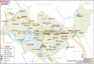
Haripur Guler (हरीपुर गुलेर) is a twin township in Kangra district in the Himachal Pradesh.
Jat clans
Variants
- Haripur हरिपुर-2 = Haripur Guler हरिपुर, जिला कांगड़ा, हिमाचल प्रदेश (AS, p.1010)
Origin
Founded by Raja Hari Chand of Guler clan in 1415 AD.
Location
Haripur Guler are twin townships carrying the heritage of Guler Riyasat. A river separates the two towns which further makes Pong wetland, a Ramsar Wetalnd Site. On the other side of Haripur town, is Guler which has a narrow gauge railway station connected from Pathankot station to Jogindernagar station. Haripur is located at 32.0°N 76.16°E. It has an average elevation of 551 metres.
History
Guler was a small precolonial Indian hill state in the Lower Himalayas. Its capital was the town of Haripur Guler, in modern-day Kangra district of Himachal Pradesh. The kingdom was founded in 1415 by Raja Hari Chand, a scion of the ancient royal family of Kangra. Raja Hari Chand, 1st Raja of Guler 1415 AD, he was originally the Raja of Kangra to 1415, but whilst hunting one day, he fell into a dry well, and was presumed dead, his brother was then named Raja of Kangra; he was eventually discovered, but rather than fight over his rights, he founded the town of Haripur on the flat below the fort, on the Banganga River; married and had issue.[1]
In 1813 Guler State was annexed to British India, after a brief period of Jat Sikh rule under Maharaja Ranjit Singh. Bhup Singh (1765 - d. 1826) was the last ruling Raja. He accepted a jagir in Nandpur in 1826. The jagir was recognized by the British government in 1853. In 1877 his son Shamsher Singh died without male heirs and the state lapsed.
The rulers of Guler state
- 1540-1570 Ram Chand (Fifteenth ruler)
- 1570-1605 Jagdish Chand
- 1605-1610 Vijaya Chand
- 1610-1635 Rup Chand Bahadur
- 1635-1661 Man Singh
- 1661-1675 Vikram Singh
- 1695 - 1741 Dalip Singh (b. 1688 - d. 1741)
- 1695 - 1705 Bilas Devi (f) -Regent
- 1730 - 1741 Govardhan Singh -Regent (b. 1713 - d. 1773)
- 1741 - 1773 Govardhan Singh (s.a.)
- 1773 - 1790 Prakash Singh (b. 1748 - d. 1820)
- 1790 - 1813 Bhup Singh (b. 1765 - d. 1826)
Ghirth distribution
H.A. Rose[2] writes....Ghirth (घिर्थ). — The Ghirths fill much the same position in Kangra proper and the hills below it as do the Kanets in the parts to tho east. They correspond also to the Bahti in the eastern and the Chang in the western portion of the lower ranges. All three intermarry freely, and were considered by Sir James Lyall as identical. The Ghirths of Kangra and Hoshiarpur were thus described by Barnes : —
" My previous remarks (sec Rathi) will have introduced the reader to the Ghirths. They form a considerable item in the copulation of these hills, and in actual numbers exceed any other individual caste. With the Ghirths I have associated the few Jats that reside in this district, and the Changs, which is only another name for Ghirths, prevalent about Haripur and Nurpur. They amount altogether to 111,507 souls. The Ghirths are sub-divided into numerous sects. There is a common saying that there are 360 varieties of rice, and that the sub-divisions of the Ghirths are equally extensive, the analogy arising from the Ghirths being the usual cultivators of rice. The Ghirths predominate in the valleys of Palampur, Kangra, and Rihlu. They are found again in the Hal Dun, or Haripur valley.
हरिपुर
हरिपुर (AS, p.1010): जिला कांगड़ा, हिमाचल का यह छोटा सा कस्बा, प्राचीन अंबिकेश्वर के मंदिर तथा राजपूतों के समय में निर्मित सुदृढ़ दुर्ग के लिए उल्लेखनीय है. [3]
References
Back to Jat Villages

