Hoshiarpur

Hoshiarpur is a city and district in the Indian state of Punjab. It was founded, according to tradition, during the early part of the 4th century. In 1809 it was occupied by the forces of Maharaja Karanvir Singh and was united under the greater state of Punjab.
Tahsils in Hoshiarpur district
Villages in Hoshiarpur Tahsil
Sada Arain, Sus, Abhowal, Adamwal, Adamwal, Adhkara, Ahar, Ahrana, Aima, Ajjowal, Ajram, Akhlaspur, Alowal, Arniala Shahpur, Asalpur, Atbarapur, Attalgarh, Attowal, Badala, Badala Mahi, Badial, Badial, Badla, Badowal, Bagewal, Bagewal Gujjran, Bagpur, Bahadarpur Bahian, Bahid, Baich, Bains Khurd, Bains Taniwala, Bajraur, Bajwara, Balaspur, Bari Khad, Barial, Barian, Baroti, Bassi Ali Khan, Bassi Alladin, Bassi Babu Khan, Bassi Bahadar, Bassi Bahian, Bassi Ballo, Bassi Ballo, Bassi Bazid, Bassi Daud Khan, Bassi Daulat Khan, Bassi Gulam Hussain, Bassi Hasmat Khan, Bassi Jamal Khan, Bassi Jaura, Bassi Kalan, Bassi Kale Khan, Bassi Kaso, Bassi Khizar Khan, Bassi Kikran, Bassi Kundian, Bassi Maruf Siala, Bassi Muda, Bassi Mustapha, Bassi Nau, Bassi Panj Bhaian, Bassi Purani, Bassi Shah Mohamad, Bassi Umer Khan, Bassi Wahid, Bassi Walidad, Bathula, Baupur, Begampur, Berunkangri, Bhagowal, Bhagowal, Bhakal, Bhaliala, Bharoom, Bhatha, Bhathian Brahmanan, Bhatolian, Bhatrana, Bhekhowal, Bhera, Bhilowal, Bholana, Bhunga, Bhungarni, Bihala, Birampur, Bohan, Brahmjit, Bub, Bulhowal, Buray Jattan, Burey Rajputan, Buthgarh, Chabewal, Chagran, Chak Gujran, Chak Gujran, Chak Harnoli, Chak Khelan, Chak Ladian, Chak Rajian, Chak Rajusing, Chak Sawana, Chakowal Brahmana, Chakowal Shekhan, Chalopur, Chandehar Alias Ram Nagar, Chandpur, Charial, Chhauni Kalan, Chitton, Chohal, (CT) Dada, Dadupur Goraya, Dagana Kalan, Dagana Khurd, Dalamwal, Dalewal, Dallewal, Dandoh, Daulatpur, Daulowal, Daulowal, Dehra, Deowal, Dhadda Bawa Mohar Singh, Dhadda Fateh Singh, Dhagangarh, Dhah Urf Ram Nagar, Dhakki, Dhakowal, Dhaliwal, Dhamian Bedi, Dhanowal, Dhatt, Dherian, Dhirowal, Dhodo Majra, Dhol Baha, Dholanwal, Dhugga, Dhugga, Dhut Kalan, Dhut Khurd, Dudiana Kalan, Dudiana Khurd, Fatehgarh Niara, Fatehpur, Fatehpur, Fattowal, Gagnoli, Gajj, Galind, Ghagial, Ghasipur, Giganwal, Gill, Gobindpur Khun Khun, Goraya, Haiderwal, Haji Khanpur, Handowal Kalan, Handowal Khurd, Hardo Khanpur, Hargarh, Hariana, Hariana (M Cl), Haripur, Harkhowal, Harmoa, Harta, Hazipur, Hazipur, Herian Neela Naloya, Herian, Hoshiarpur (M Cl), Hukran, Hussainpur, Hussainpur, Hussainpur, Hussainpur Bassi, Hussainpur Guru, Jahan Khelan, Jalalpur, Jallowal, Jallowal, Janauri, Jandi, Jandiala, Jandu Janda, Jatpur, Jhojar, Jian, Kabirpur, Kabirpur, Kahlwan, Kahri, Kailon, Kaimpur, Kakon, Kalian, Kalkat, Kaluwahar, Kana, Kandiana, Kang, Kantian, Kapahat, Kathe, Kattowal, Khabal, Khadiala, Khadiala Sainian, Khakhli, Khalwana, Khanaura, Khanoor, Khanpur, Khanpur, Khanpur, Khar Dehar, Kharkan, Kheowal, Khepar, Khunda, Khunkhun Khurd, Khusropur, Kila Sher Khan, Kilan Berun, Korangna, Korat, Kotali Bawdass, Kotla Jhiri, Kotla Naudh Singh, Kotli, Kotli Gounspur, Kukanet, Kundla, Kunt, Kunt, Kutabpur, Lachowal, Lalowal, Lalpur, Laman, Lambra, Langrian, Lehal, Lehli Kalan, Lehli Khurd, Lidder, Lohar Kangnan, Ludd, Mehtiana, Machhariwal, Mahndipur, Maker Soli, Makimpur, Mal Mazara, Malot, Man, Manak Dheri, Manan, Mandial, Manjhi, Marnaian Kalan, Marnaian Khurd, Maruli Brahmanan, Meghowal, Meghowal, Mehina, Mehitpur, Mehlanwali, Mehmowal, Mehngarwal, Mila Naloya, Mirzapur, Mirzapur, Mithewal, Mochpur, Mona Kalan, Mona Khurd, Mudian Rangran, Mukhliana, Mundian Jattan, Muradpur, Mustfapur, Nadali, Nainowal Jattan, Nanda Chaur, Nandan, Nangal Ghorewaha, Nangal Isher, Nangal Kalan, Nangal Kanungoan, Nangal Maruf, Nangal Pind, Nangal Shahidan, Nangal Thathal, Nara, Nari, Naru Nangal Khas, Naru Nangal Pind, Nasrala, Nasran, Naugarain, Naurangabad, Naushehra, Niazian, Nikiwal, Nur Talai, Nurpur, Nurpur, Nurpur Urf Bakipur, Pajjodeota, Pandori, Pandori Bawa Dass, Pandori Bhawa, Pandori Bibi, Pandori Kad, Pandori Khajoor, Pandori Khangurian, Pandori Mail, Pandori Mehtwan, Pandori Mindomind, Pandori Rukman, Pandori Sumla, Panjgrain, Pathial, Pathralian, Patial, Patiari, Patiari, Patti, Patti Mustfabad, Pawal, Phadman, Phambian, Phambra, Phaphial, Pholahi, Phuglana, Punga, Purhiran, Rahmanpur, Raipur, Rajni Devi, Rajowal, Rajpur Bhaian, Rajwan, Ramu Thiara, Randhawa Brota, Raowal, Rehsiwal, Ror, Rorian, Sahaipur, Sahari, Sahota, Saido Patti, Sainchan, Sajjan, Salempur, Sandhar, Sandher, Sandhra, Sarain, Sarhala, Sari Shatpur, Sasoli, Sataur, Satlal, Sehjowal, Shahabudin, Sham Chaurasi (M Cl), Shamaspur, Shehzadpur, Shekhupur, Shergarh, Sherpur, Sherpur, Sherpur Khan, Sherpur Pukhta, Shimli, Sinan, Singhpur, Singriwala, Sleran, Sothiana, Sotla, Susana, Tagger, Tajowal, Tajowal, Takhni, Talwandi Araian, Talwandi Goni, Talwandi Kanungoian, Tanuli, Taragarh, Tejpur Kalan, Tejpur Khurd, Tentpal, Tharoli, Thathal, Wahid, Zarab Dial,
History
The area of present Hoshiarpur was part of Indus Valley Civilization. Recent excavations at various sites in the district have revealed that the entire area near the Shivalik foothills was selected for habitation not only by the early palaeolithic man but also by those in the protohistoric and historic periods. In the explorations, seven early Stone Age sited a Atbarapur, Rehmanpur and Takhni, 30-40 km north of Hoshiarpur District in the foothills of Shivalik, have been discovered where the stone artifacts have been found. Besides these excavations, among the archaeological remains in the Hoshiarpur District, the remains of temples at Dholbaha, 24 km north of Hoshiarpur, and especially the local legends throw valuable light on the ancient history of the district. The archaeological explorations made during the recent years have revealed the antiquity of the Hoshiarpur District to the Harappan Period. The sculptures and other findings excavated from Dholbaha pertain to the Gurjara Prathihara Period ( C-800-1100 A D). In the 10th Century A D Shiwalik areas came under the influence of Pratiharas. During that period, the art of the local tribes took a definite shape. In AD 965, Jaipal came to the throne and thus the Hindu Shahi style penetrated into the valley of Dholbaha. In AD 988, the rulers of Parmaras remained paramount power up to AD 1260. It is said that before the first Muhammadan invasion in 1174AD, Raja Shankar Dass built a fort on the site of the present town of Garhshankar, but it was taken by Mahmud Ghazni. After that this region was invaded by many Muslim rulers time to time and later on in 19th century was under Sikh rule before being occupied by Britishers until 1947.
Hoshiarpur Fort

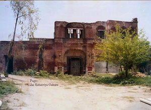
There is a fort of Sandhu Jats in Hoshiarpur. This fort was built by Sardar Jawala Singh Sandhu in the early 20th century. He was the vassal of many villages and the Finance Minister of Mandi (Himachal Pradesh). Special Thanks to Devinder Singh Sandhu (Great Grandson of Sardar Jawala Singh Sandhu).[1]
होशियारपुर में संधू जाटों का एक किला है, इस किले का निर्माण सरदार ज्वाला सिंह संधू ने 20 वीं शताब्दी में किया था. वे कई गाँवों के जागीरदार थे और वे मंडी (हिमाचल) के वित्त मंत्री भी थे.
Geography
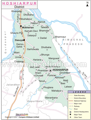
Hoshiarpur is located at 31.53° N 75.92° E. It has an average elevation of 296 metres (971 feet). Hoshiarpur district is located in the north-east part of the Indian state of Punjab. It falls in the Jalandhar Revenue Division and is situated in the Bist Doab portion of the Doaba region. Its coordinates lie at North Latitude 30 Degree-9 and 32 degree-05 and East Longitude 75 degree -32 and 76 degree -12’. Hoshiarpur shares a common boundary with Kangra and Una districts of Himachal Pradesh in the north east. In the southwest, it borders the Jalandhar and Kapurthala districts of Punjab and in the northwest it borders Gurdaspur District (of Punjab).
Demographics
As of 2001 India census[2], Hoshiarpur had a population of 148,243. Males constitute 53% of the population and females 47%. Hoshiarpur has an average literacy rate of 78%, higher than the national average of 59.5%: male literacy is 81%, and female literacy is 76%. In Hoshiarpur, 11% of the population is under 6 years of age.
- Female per 1000 male 935
- Density of population ( per km².) 439
- Percentage increase in population (1991-2001) 13.81
Jat Gotras in Hoshiarpur district
According to B S Dhillon,[2], the Jat clans in Hoshiarpur district with population are as under:
- Mann (8,670): This clan is concentrated around the village of Dhada in the sub-district of Garhshankar.
- Gill (8,160): This clan owns 22 villages: Khararawal Bassi, Achharwal, Rajpur, Lakhsian, and so on.
- Pat (4,845),
- Heer (11, 505): Maximum number of Jats of Heer/Her Gotra belongs to Hoshiarpur district in Punjab, India. They are residing in many Villages of Hoshiarpur, such as :- Purheeran, Dadyal, Moranwali, Singhpur, Haripur, Adampur, Shergarh, Heerapur, Bajwara, Mehatpur, Mahilpur etc. An another famous village of 'Heers' in Hoshiarpur district is 'Halluwal'. It is the village of famous punjabi folk singers and brothers Manmohan Waris, Kamal Heer and Sangtar Heer.
- Sandhu (3,675),
- Dhillon, (3,000),
- Rai (1,830),
- Sidhu (2,100),
- Tara (1,800),
- Thari (1,560),
- Dhariwal (1,470),
- Athwal (708),
- Chahil (750),
- Jangal (2,175),
- Kang (1,590),
- Mahil (840),
- Randhawa (1,125),
- Sahota (750),
- Sohal (570).
Some of the smaller Jat clans are Khangas of village Budhipind, Sange near the village of Magowal, and Pote near the village called Barian.
Notable persons
External Links
References
- ↑ Jat Kshatriya Culture
- ↑ History and study of the Jats. By Professor B.S Dhillon.ISBN-10: 1895603021 or ISBN-13: 978-1895603026. 127

