Mahanadi River
| Author:Laxman Burdak, IFS (Retd.) |


Mahanadi (Hindi: महानदी, Odia: ମହାନଦୀ) is a major river in East Central India. The river flows through the states of Chhattisgarh and Odisha.
Variants of name
- Mahanadi महानदी (AS, p.723)
- Chitrotpala चित्रोत्पला (उड़ीसा) (AS, p.337)
- Chitrotpala - below its junction with Pairi and Utpalesvara before the junction
- Mahanadi river
- River Mahanadi
Origin
It rises from a place Sihawa, 6 kms from Farsiya village 442 metres above sea level south of Nagri town in Dhamtari district of Chhattisgarh.[1][2]
Course
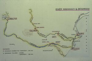
For the first 80 kms of its course, the Mahanadi flows in a northerly direction and drains the Raipur district and touches eastern portions of Raipur city.
After being joined by the Seonath River, the river flows in an easterly direction through the remaining part of its journey. It is joined by the Jonk River and Hasdeo Rivers here before entering into Odisha after covering about half of its total length.
Near the city of Sambalpur, it is dammed by the largest earthen dam in the world, the Hirakud Dam. A composite structure of earth, concrete and masonry, the dam measures 24 kms including the Dykes. It spans two hills; the Lamdungri on the left and the Chandili Dunguri on the right. It also forms the biggest artificial lake in Asia, with a reservoir holding 743 square kms at full capacity, with a shoreline of over 640 kms.
After the formation of Chhattisgarh State, the major portion of Mahanadi basin now lies in Chhattisgarh. Presently, only 154 square kms basin area of Hasdeo River in Anuppur District lies in Madhya Pradesh.
Before the construction of the dam in 1953, the Mahanadi was about a mile wide at Sambalpur and carried massive amounts of silt, especially during the monsoon. Today, it is a rather tame river after the construction of the dam and is joined by the Ib, Ong, Tel and other minor streams. It then skirts the boundaries of the Baudh district and forces a tortuous way between ridges and ledges in a series of rapids until it reaches Dholpur, Odisha. The rapids end here and the river rolls towards the Eastern Ghats, forcing its way through them via the 64 kms long Satkosia Gorge. The Satakosia Gorge ends at Badamul of Nayagarh. Dense forests cover the hills flanking the river here. The river enters the Odisha plains at Naraj, about 11 kms from Cuttack, where it pours down between two hills that are a mile apart. A barrage has been constructed here to regulate the river's flow into Cuttack.
The river traverses Cuttack district in an east-west direction. Just before entering Cuttack, it gives off a large distributary called the Kathjori. The city of Cuttack stands on the spit separating the two channels. The Kathjori then throws off many streams like the Kuakhai, Devi and Surua which fall into the Bay of Bengal after entering Puri district. The Kathjori itself falls into the sea as the Jotdar.
Other distributaries of Mahanadi include the Paika, Birupa, Chitroptala river, Genguti and Lun. The Birupa then goes on to join the Brahmani River at Krushnanagar and enters the Bay of Bengal at Dhamra. The Mahanadi proper enters the sea via several channels near Paradeep at False Point, Jagatsinghpur. The combined Delta of the Mahanadi's numerous distributaries and the Brahmani is one of the largest in India.
It drains an area of around 141,600 square kms and has a total course of 858 kms[3].
Tributaries
- Birupa River
- Brahmani River
- Chitroptala River
- Devi River
- Daya River (Dhauli)
- Genguti River
- Hasdeo River
- Ib River
- Jonk River
- Kathjori River
- Kuakhai River
- Lun River
- Ong River
- Paika River
- Seonath River
- Surua River
- Tel River
Places of historical importance
- Dhamtari (Chhattisgarh)
- Rajim (Chhattisgarh)
- Arang Raipur (Chhattisgarh)
- Sirpur (Chhattisgarh)
- Bilaigarh (Chhattisgarh)
- Dhauli hills are located on the banks of the Daya River, 8 km south of Bhubaneswar in Orissa, India. Daya River is a tributary of Mahanadi.
- Kalinga
- Sambalpur (Orissa)
- Boudh district (Orissa)
- Dholpur, Odisha
- Badamul of Nayagarh (Orissa)
- Naraj, about 11 kms from Cuttack
- Sonapur (Orissa)
- Cuttack (Orissa)
- Yayatinagar
- Jagatsinghpur
In Skanda Purana
Skanda Purana: Lord Vishnu said -- Purushottam Kshetra is situated at the sea-shore, to the south of river Mahanadi. This sacrosanct place of mine does not get affected by deluge. I dwell at this holiest place as Lord Purushottam. There is a holy pond called Rohin in the vicinity. Anybody who takes a holy dip in that pond gets absolved of all his sins. O Brahma! You must pay a visit to Purushottamakshetra where spending a day bestows virtues greater than all the austerities combined together.
In Ramayana
Ramayana in Kishkindha Kanda Sarga 41 describes The Empire of Holy Vanaras to the South: Sugreeva sends Vanaras in search of Sita to southward which troop includes Hanuman, Jambavanta, Nila and others and Angada is its leader. Sugreeva gives a vivid picture of the southern side of Jambudvipa. Mahanadi is mentioned in Ramayana (IV.41.9).[4] .....8,9,10. "Search the thousand crested Vindhya mountains abounding with numerous tress and climbers, then the delightful Narmada river coursing a little southerly to that range, which is adored by great snakes, along with wonderful River Godavari, as well as River Krishnaveni and Maha Nadi, and then the greatly auspicious Varada River which is an adoration to great snakes. And the territories of Mekhala, Utkala, the cities of Dasharna, kingdoms of Abravanti, Avanti, and Vidarbha, also thus the charming kingdom of Mahishaka, are to be searched thoroughly. [4-41-10]"
In Mahabharata
Mahanadi (महानदी) (River) is mentioned in Mahabharata (VI.10.13),
Chitropala (चित्रॊपला) (River) in Mahabharata (VI.10.32)
Bhisma Parva, Mahabharata/Book VI Chapter 10 describes geography and provinces of Bharatavarsha. Mahanadi (महानदी) (River) is mentioned in Mahabharata (VI.10.13). [5]
Chitropala (चित्रॊपला) (River) is mentioned in Mahabharata (VI.10.32).[6]....O Bharata; and Chitropala. Chitraratha, and Manjula, and Vahini; and Mandakini, and Vaitarani, and Kosa, and Mahanadi; ....
चित्रोत्पला
विजयेन्द्र कुमार माथुर[7] ने लेख किया है ...चित्रोत्पला (उड़ीसा) (AS, p.337): कोणार्क के निकट बहने वाली महानदी का ही नाम चित्रोत्पला है। कहा जाता है कि कोणार्क के निकट मंदिर के निर्माण के समय चिनाव नदी और चित्रोत्पला नदियों का प्रवाह रोकना पड़ा था। चित्रोत्पला का उल्लेख महाभारत भीष्म पर्व महाभारत 9,34 में भी है--'चित्रोत्पला चित्ररथां मंजुलां वाहिनी तथा, मंदाकिनी वैतरणीं कोषां चापि महानदीम्'।
महानदी
विजयेन्द्र कुमार माथुर[8] ने लेख किया है ...1. महानदी (AS, p.723): महेंद्र पर्वत के निकट से होकर बहने वाली नदी जो उड़ीसा को सिंचित करती हुई कटक के पास बंगाल की खाड़ी में गिरती है. श्रीमद्भागवत 5,19,18 में शायद इसी का उल्लेख है--'महानदी वेदस्मृतिऋर्षिकुल्या'. महाभारत भीष्म पर्वत 9,14 में भी महानदी का नाम उल्लेख है--'नदीः पिबन्ति बहुला गङ्गां सिन्धुं सरस्वतीम्, गॊदावरीं नर्मदां च बाहुदां च महानदीम्' (VI.10.13)
2. महानदी (AS, p.723): गया (बिहार) के निकट बहने वाली फल्गु को ही महाभारत वन पर्व 95,9 में 'महानदी' नाम से अभिहित किया गया है--'नगो गायशिरो यात्रा पुण्या चैव महानदी'. फल्गु को स्थानीय रूप से आज भी महाना कहा जाता है जो उसे ही महानदी का अपभ्रंश है. उपयुक्त उल्लेख में महानदी शब्द व्यक्तिवाचक संज्ञा है.
महानदी परिचय
महानदी मध्य भारत के मध्य छत्तीसगढ़ राज्य की पहाड़ियों में सिहावा के पास से निकलती है। इस नदी को 'उड़ीसा का शोक' भी कहा जाता है, जिसका कारण इसकी बाढ़ विभीषिका है। उड़ीसा प्राचीन समय से बाढ़ और सूखे से ग्रसित रहा है। यह नदी 'छत्तीसगढ़ राज्य की गंगा' भी कही जाती है। इस नदी के द्वारा 58.48% क्षेत्र का जल संग्रहण किया जाता है।
महानदी नदी का ऊपरी प्रवाह उत्तर की ओर महत्त्वहीन धारा के रूप में होता है और छत्तीसगढ़ मैदान के पूर्वी हिस्से को अपवाहित करता है। बालोदा बाज़ार के नीचे शिवनाथ नदी के इससे मिलने के बाद यह पूर्व दिशा में मुड़कर उड़ीसा राज्य में प्रवेश करती है और उत्तर व दक्षिण में स्थित पहाड़ियों को अपवाहित करने वाली धाराओं से मिलकर इसके बहाव में वृद्धि होती है। संबलपुर में इस नदी पर निर्मित हीराकुंड बाँध के फलस्वरूप 55 किलोमीटर लम्बी कृत्रिम झील का निर्माण हो गया है। इस बाँध में कई पनबिजली संयंत्र हैं। बाँध के बाद महानदी दक्षिण में घुमावदार रास्ते से होते हुए वनाच्छादित महाखड्ड के ज़रिये पूर्वी घाट को पार करती है। पूर्व की ओर मुड़कर यह कटक के पास उड़ीसा के मैदान में प्रवेश करती है और कई धाराओं के माध्यम से फ़ाल्स पाइन्ट के पास बंगाल की खाड़ी में मिल जाती है।
महानदी की कुल लम्बाई 900 किलोमीटर है और इसका अनुमानित अपवाहित क्षेत्र 132,100 वर्ग किलोमीटर है। यह भारतीय उपमहाद्वीप में सर्वाधिक सक्रिय गाद जमा करने वाली नदियों में से एक है। यह नदी सिंचाई की कई नहरों को, विशेषकर कटक के पास, जल प्रदान करती है। इसके एक मुहाने पर स्थित पुरी एक विख्यात तीर्थस्थल है। महानदी को मुख्यत: तीन भागों में विभक्त किया जा सकता है-
ऊपरी महानदी बेसिन: इसका अधिकांश भाग बस्तर तथा रायपुर में है। सिहावा पर्वत से निकलकर एक संकरी घाटी से होती हुई उत्तर-पश्चिम की ओर लगभग 50 किलोमीटर दूरी तक प्रवाहित होकर बस्तर में कांकेर के निकट स्थित पानीडोंगरी पहाड़ियों तक पहुँचता है। यहाँ यह पूर्व की ओर हो जाती है। यहाँ पर पैरी एवं तेल नदी ज़िले के दक्षिणी भाग का जल एकत्र कर महानदी में डालती हैं। बस्तर से नदी की लम्बाई 64 किलोमीटर तथा प्रवाह क्षेत्र 2,640 वर्ग किलोमीटर है।
मध्य महानदी बेसिन: इसके अंतर्गत दुर्ग, मध्य रायपुर और बिलासपुर ज़िले का कुछ भाग सम्मिलित है। यह सम्पूर्ण क्षेत्र महानदी की प्रमुख सहायक शिवनाथ नदी का जलग्रहण क्षेत्र है, जिसमें उत्तरी-पश्चिमी एवं दक्षिणी सीमान्त उच्च भूमि से निकलने वाली सभी सहायक नदियाँ एवं नाले आकर मिलते हैं। शिवनाथ नदी रायपुर ज़िले में शिवरीनारायण से ऊपर किरौन्जी नामक स्थान में पश्चिम से आकर महानदी में मिलती है। जमुनिया तथा खोरसी नदी दक्षिण से आकर मिलती हैं।
निचला महानदी बेसिन: इसके अंतर्गत बिलासपुर, रायपुर तथा रायगढ़ ज़िले आते हैं। शिवनाथ महानदी के संगम स्थल से महानदी एक तीव्र मोड़ लेकर बिलासपुर और रायपुर ज़िलों के मध्य तथा रायगढ़ और सारंगगढ़ तहसील के मध्य एक प्राकृतिक सीमा बनाती है, जो पूर्वी ढलान की ओर प्रवाहित मध्य प्रदेश से बाहर निकल जाती है। इस क्षेत्र में इसके उत्तर की ओर हसदो, माँड एवं ईब नदियाँ तथा दक्षिण की ओर से जोंक एवं सुरंगी आकर मिलती हैं। रायपुर ज़िले में नदी की लम्बाई 192 किलोमीटर तथा प्रवाह क्षेत्र 8,550 वर्ग किलोमीटर है।
संदर्भ: भारतकोश-महानदी
महानदी: यह छत्तीसगढ़ प्रदेश की जीवन रेखा है । महानदी रायपुर के सिहावा पर्वत से 42 मीटर की ऊंचाई से निकलकर दक्षिण-पूर्व की ओर से उड़ीसा के पास से बहते हुये बंगाल की खाड़ी में समा जाती है । छत्तीसगढ़ राज्य में इसकी लम्बाई 286 किमी. है । महानदी की कुल लम्बाई 858 किमी. है । इस पर दुधावा, माढ़मसिल्ली, गंगरेल, सिकासेर, सोंढुर बांध बने हैं । उड़ीसा पर विशाल हीराकुण्ड बांध भी इसी नदी पर बना है.[9]
References
- ↑ Imperial Gazetteer2 of India, Volume 16, page 431
- ↑ Hydrology and Water Resources of India By Sharad K. Jain, Pushpendra K. Agarwal, Vijay P. Singh
- ↑ Mahanadi River (river, India)- Encyclopedia Britannica
- ↑ ततो गोदावरीम् रम्याम् कृष्णावेणीम् महानदीम्....(IV.41.9)
- ↑ नदीः पिबन्ति बहुला गङ्गां सिन्धुं सरस्वतीम, गॊदावरीं नर्मदां च बाहुदां च महानदीम Mahabharata (VI.10.13)
- ↑ बरह्माणीं च महागौरीं दुर्गाम अपि च भारत, चित्रॊपलां चित्रबर्हां मज्जुं मकरवाहिनीम (VI.10.32)
- ↑ Aitihasik Sthanavali by Vijayendra Kumar Mathur, p.337
- ↑ Aitihasik Sthanavali by Vijayendra Kumar Mathur, p.723
- ↑ छत्तीसगढ़ में नदियाँ
Back to Rivers/Rivers in Chhattisgarh/Rivers in Orissa/Rivers in Ramayana/Rivers in Mahabharata

