Nachane Ki Talai
| Author:Laxman Burdak, IFS (R) |


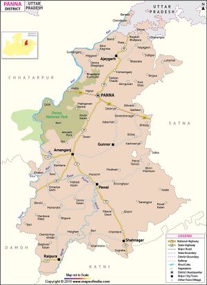
Nachane Ki Talai (नचने की तलाई) is an archaeological site in Gunour Tehsil of Panna District in Madhya Pradesh, India.
Location
Nachane-Ki-Talai is near the border of Satna district. It is 2 miles to the west of the town of Ganj, which is 25 miles to the south-east of Panna, and 15 miles to the south-west of Nâgodh (Satna district)
Variants
- Nachane Ki Talai नचने की तलाई (बुंदेलखंड), (म.प्र.) (AS, p.477)
- Nachnā-kī-talāi
- Nachne-ki-talai
History
Nachane Ki Talai slab of Vyāghradeva: A rough slab of stone. Its dimensions are not reported, but must be larger than the inscribed area, which is reported. It bears an incomplete inscription (inscription IN000198) on one of its sides and a complete inscription (inscription IN000199) on its face, assumed to be the top. ASIR 21:98 assumes the former is an unfinished repetition of the latter; leet 1888:233 and Mirashi 1963:89 (following Fleet) believe the former was left incomplete because that side of the stone was found too rough, and was re-commenced on another side.[1]
The Nachnā-kī-talāi stone inscription was located in 1883-84 by Alexander Cunningham. The inscription is inscribed on two sides of a loose slab which was found on the ground outside the fort of Kuṭhārā. (Shastri, p. 55). The inscription is identical to the one found at Ganj. The inscription records the meritorious action of Vyaghradeva who is described in the inscription as meditating upon the feet of Pṛthivīṣeṇa. (Shastri, p. 55) It has not been definitively proven whether the inscriptions refer to Pṛthivīṣeṇa I or Pṛthivīṣeṇa II. It is assumed that Vyāghradeva was a feudatory or officer under the Pṛthivīṣeṇa mentioned in the inscription.[2]
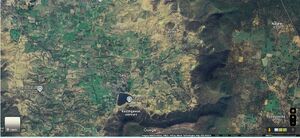
History details: Discovered by Cunningham in 1883-84, lying on the ground outside the fort of Kuṭhārā near the village Nacne-kī-Talāī, probably around 24.399298, 80.447427. Mirashi_1963:89 gives the location of the place as "about seven miles north-west of Jasō." ASIR 21:95 calls the village Nachna and says it is "2 miles to the west of the town of Ganj, which is 25 miles to the south-east of Panna, and 15 miles to the south-west of Nâgodh." He adds that Kuṭhārā, apparently the area between Ganj and Nachna, is believed to have been an ancient city and there are many remains of brick buildings in the area. The same site is described in PRAS-W 1920:60 as being "Seven miles to the south-east of Jaso, as the crow flies." As of 2016, Google Maps shows a region named Nachne about seven miles southwest (neither northwest, nor southeast) of Jaso. The village of Ganj is a little further to the southwest of this region. The two temples described by Cunningham as being in Nachna (a Chaturmukha Mahādeva and a Pārvatī temple) seem to be just outside this Ganj on the south (24.399298, 80.447427), and the former is named Nachna Kuthar ka Chaumukhnath Mandir, so the identity is quite certain. The fort may be the elevated region a little further to the south beyond a lake (perhaps the Talai in the name?).[3]
Nachane-Ki-Talai Stone Inscriptions of Vyaghradeva
[p.89]: These two inscriptions were discovered by General Cunningham in 1883-84. He published his reading of the larger of them, together with facsimiles of both, in his Reports of the Archaeological Survey of India, Vol. XXI, pp. 97 f. They were next edited with facsimiles and a translation by Dr. Fleet in the Corpus Inscriptionum Indicarum, Vol. III, pp. 233 f. They are edited here from the same facsimiles.
The inscriptions are on a loose slab which was found lying on the ground outside the Fort of Kuthara near the village Nachne-ki-talai, about seven miles north-west of Jaso, the chief town of the former Jaso State, now included in Madhya Pradesh. Inscription No. 20 is incomplete and is engraved on one of the sides of the slab, while inscription No. 21 which is complete is on the face of it. The former inscription was left incomplete probably because that side of the stone was found too rough. The inscription was therefore commenced again and finished on what is now the front side of the slab.
The writing of No. 20 covers a space of about 1' 9-3/4" broad by 7-1/2" high; that of No, 21, about 1' 9" broad by 1' 1" high. In the centre of the larger inscription there is the figure of a wheel which Jayaswal took to be a characteristic symbol of the Vakatakas. The characters belong to the box-headed variety of the southern alphabets. There has been a great difference of opinion about the age of these inscriptions, which, as stated below, refer themselves to the reign of the Vakataka Maharaja Prithivishena. Dr. Fleet did not examine this question. Perhaps there was no need to do so as there was only one Vakataka king of the name Prithivishena known when he edited these records. He naturally assigned them to Prithivishena I, mentioned in the grants of Pravarasena II1 The Balaghat plates which were discovered later have brought to notice another king of that name, viz-, Prithivishena II, who was the fourth lineal descendant of Prithivishena I. Since then scholars have been sharply divided on the question of the identity of the Prithithvishena during whose reign the present records were incised. Some of them such as Dr. Sukthankar2, Dr, Jayaswal3 and Prof. H. C. Raychaudhuri4 thought that he was the first king of that name. Rao Bahadur K. N. Dikshit, however, pointed out that the characters of the Nachna and Ganj inscriptions were later in date than those of the Poona plates of Prabhavatigupta5. He therefore identified the Prithivishena of these inscriptions with Prithivishena II of the Balaghat plates. The same opinion has been expressed by Prof. Jouveau-Dubreuil6 and Dr. R. C. Majumdar7 Recently Dr. D. C. Sircar has reopened the question by pointing out that ‘ the palaeographical peculiarities of the Nachna and Ganj inscriptions are undoubtedly earlier than those of even the Basim plates of Vindhyashakti II, a grandson of Pravarasena I8. He has drawn pointed attention to the triangular form of
1 C.I.I., Vol. III, p. 233.
2 Ep. Ind., Vol. XVII, p. 13.
3 History of India, etc., p. 73.
4 Political History of Ancient India, p. 541.
5 Ep. Ind., Vol. XVII, p. 362.
6 Ind. Ant., Vol. LV, pp. 103 f.
7 J.R.A.S.B., Vol. XII, pp. 1 f.
8 H.C.I.P., Vol. III, p. 179, n. 1.
[p.90]: v and the old forms of t and j occurring in the present inscriptions. He is therefore definitely of the opinion that these inscriptions belong to the reign of Prithivishena I. In view of this conflict of opinions it is necessary to examine this question rather closely. Dr. Sircar seems to think that the triangular form of v went out of use soon after the time of Prithivishena I and so these records cannot be referred to the reign of Prithivishena II, when the rectangular form of that letter was in vogue. This is not borne out by the inscriptions of the age. As a matter of fact, the rectangular form of v had come into use even before the time of Prithi- vishena I. We notice several instances of it in the Eran stone inscription1 of Samudragupta; see kulavadhuh, line 20, vichintya, line 24 etc. On the other hand, the triangular form of V did not disappear soon after the age of Prithivishena I ; for we find it used in the Sanchi inscription2 of Chandragupta II, dated G.93; see e.g. mahāvihāre, line 1, sarvva-guna-, line 8 etc. Indeed, it continued in use much longer; for while the inscriptions of the Vakatakas generally use the rectangular v, the Podagadh stone inscription of Skandavarman3 and the Kesaribeda plates of Arthapati4 use the triangular form of that letter; see e.g. Bhavadattasya, line 3, and a-praveshyam, line 8 in the former, and vibhah, line 1 and dhruva-, line 7 in the latter. The Nala kings Skandavarman and Arthapati did not flourish earlier than Prithivishena II5. It is noteworthy that all the inscriptions mentioned above are Incised in box-headed characters. The triangular form of v is therefore no indisputable evidence which would compel us to assign the present records to Prithivishena I. The same can be said of the so-called old forms of j and t ; for these also occur in the Podagadh Inscription. It is true that the form of v in the present inscriptions is more angular than that seen in the other records mentioned above; but angularity is no sure sign of an earlier age. As pointed out by Kielhorn,6 the characters of Pravarasena II’s grants are more angular than those of the Balaghat plates of his grandson Prithivishena II. Besides, it is not unlikely that the writer of the Nachna and Ganj inscriptions was influenced by the form of v current in that locality. We must note in this connection that the Nachna and Ganj inscriptions are the only records in box-headed characters from the Baghelkhand region. The standard form of characters current in that locality was nail-headed as seen in the Majhgawan plates7 of Hastin and the Bamhani plates8 of Bharatabala. The writer of the Nachna and Ganj inscriptions was apparently not quite familiar with the box-headed characters9 though he wrote the records in them evidently to please the Vakataka overlord. He therefore seems to have unconsciously imitated the form of v from the nail-headed alphabet with which he was more familiar. We find an analogous instance in the Poona plates of Prabhavatigupta. The writer of that grant, who probably hailed from North India, was not quite familiar with box-headed characters which were current in Vidarbha. He commenced to write in them the legend on the seal, but after writing the first four letters viz. Vakataka, he gave them up and wrote the remaining legend in nail-headed characters. The triangular form
1 C.I.I, Vol. III, plate facing, p. 20.
2 Ibid., Vol. III, plate facing, p. 28.
3 Ep. Ind., Vol. XXI, pp. 153 f.
4 Ibid., Vol. XXVIII, p. 12 f.
5 Dr. Sircar thinks that the Nala king Skandavarman was a contemporary of the Early Chalukya king Kirtivarman I (567-97 A.c.). See H.C.I.P., Vol. III. p. 189.
6 Ep. Ind., Vol. IX, p. 268.
7 C.I.I., Vol. III, pp. 106 ff.
8 No. 19, above.
9. As observed by Sukthankar, the letters of these epigraphs are uncouth in appearance.
[p.91]: of v is therefore no sure sign of the early age of these inscriptions1. The forms of j and t also do not preclude the view that these records belong to the reign of Prithivishena II2.
The language is Sanskrit and both the inscriptions are in prose. As regards orthography, the only point that need be noticed is the doubling of dh before y in -ānudhyāta- in line 2 of No. 21.
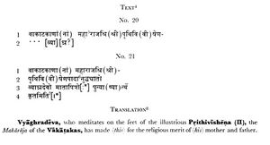
Inscription No. 20, which is incomplete, mentions in the first line the name of the Vakataka Maharaja Prithivishena. The name of his feudatory Vyaghra is incompletely incised in line 2. No. 21 mentions the names of both and records that Vyaghradeva made something, perhaps a temple, a well or a tank, for the religious merit of his father and mother.
The record is not dated, but since it belongs to the reign of Prithivishena II as shown above, it may be referred to the period 470 to 490 A.C. Vyaghradeva of the present inscriptions is probably identical with the king Vyaghra of the Uchchhakalpa dynasty who was ruling over the region in the same period. The latter’s son Jayanatha was ruling in G. 174 and G. 1773 . His reign may therefore have extended from G. 170 to G. 190. Vyaghra, his father, was therefore probably ruling from circa G. 150 to G. 170 i.e. from 470 A.C. to 490 A.C. He was thus a contemporary of the Vakataka king Prithivishena II.

Vyaghradeva, who meditates on the feet of the illustrious Prithivishena the Maharaja of the Vakatakas, has made (this) for the religious merit of (his) mother and father.
1 This form of v occurs throughout in the Bamhani plates of Narendrasena’s feudatory Bharatabala.
2 For the examination of other arguments advanced in support of the view that these inscriptions belong to the reign of Prithivishena I, see Introduction, pp. xii f., above.
3 C.I.I., Vol. III, pp. 117 and 121. The dates of the Uchchakalpa kings are recorded in the Gupta, not the Kalachuri, era as shown by me in Ep. Ind., Vol. XXIII, pp. 171 f.
8 This is a translation of No. 21. No. 20 is fragmentary and mentions only Vyaghra and the illustrious Prithivishena (II), the Maharaja of the Vakatakas.
Wiki Editor Notes:
- Kuthar (कुठार) (Jat clan) → Fort of Kuthara (कुठारा किला). Nachane-Ki-Talai Stone Inscriptions of Vyaghradeva[4] was found lying on the ground outside the Fort of Kuthara near the village Nachne-ki-talai.
- Nachana (Jat clan) → Nachana Kuthara (नचना कुठारा) is a historical site in Gunour Tehsil of Panna District of Madhya Pradesh, India. Nachna-Kuthara are some of the earliest surviving stone temples. The temple site is near the Ganj village.
- Nachana (नचना) (Jat clan) → Nachne (नचने) is a village in Gunnor tahsil in Panna district of Madhya Pradesh.Nachane-Ki-Talai Stone Inscriptions of Vyaghradeva[5] were discovered by General Cunningham in 1883-84. The inscriptions are on a loose slab which was found lying on the ground outside the Fort of Kuthara near the village Nachne-ki-talai. He was thus a contemporary of the Vakataka king Prithivishena II.
- Vyaghradeva (व्याघ्रादेव), mentioned in Nachane-Ki-Talai Stone Inscriptions of Vyaghradeva[6], was a vassal of Vakataka King Prithivishena I. Bhim Singh Dahiya[7] considers Vyaghradeva to be an ancestor of Varika kings of Mandsor.
- Vaghere (वघेरे) (Jat clan) → Vyaghradeva (व्याघ्रादेव), mentioned in Nachane-Ki-Talai Stone Inscriptions of Vyaghradeva[8] and Ganj Stone Inscriptions of Vyaghradeva[9], was a vassal of Vakataka King Prithivishena II.
नचने की तलाई
विजयेन्द्र कुमार माथुर[10] ने लेख किया है ...नचने की तलाई (AS, p.477) बुंदेलखंड, मध्य प्रदेश में स्थित एक ऐतिहासिक स्थान है। वाकाटक वंश के महाराज पृथ्वीसेन के दो अभिलेख इस स्थान पर गुप्त कालीन ब्राह्मी लिपि में अंकित पाये गए हैं। इस स्थान से प्राप्त पहले अभिलेख में केवल महाराज पृथ्वीसेन का उल्लेख है और दूसरे में इनके सामंत व्याघ्रदेव का। अभिलेखों में व्याघ्रदेव द्वारा किसी मंदिर, कूप या तड़ाग आदि के बनवाए जाने का उल्लेख है, जिसमें अभिलेख का पत्थर जड़ा रहा होगा।
External links
See also
References
- ↑ http://siddham.uk/object/ob00185
- ↑ http://siddham.uk/object/ob00185
- ↑ http://siddham.uk/object/ob00185
- ↑ Corpus Inscriptionum Indicarum Vol.5 (Inscriptions of The Vakatakas), Edited by Vasudev Vishnu Mirashi, 1963, Archaeological Survey of India, p.89-91
- ↑ Corpus Inscriptionum Indicarum Vol.5 (Inscriptions of The Vakatakas), Edited by Vasudev Vishnu Mirashi, 1963, Archaeological Survey of India, p.89-91
- ↑ Corpus Inscriptionum Indicarum Vol.5 (Inscriptions of The Vakatakas), Edited by Vasudev Vishnu Mirashi, 1963, Archaeological Survey of India, p.89-91
- ↑ Bhim Singh Dahiya: Jats the Ancient Rulers (A clan study)/Harsha Vardhana : Linkage and Identity, p.211
- ↑ Corpus Inscriptionum Indicarum Vol.5 (Inscriptions of The Vakatakas), Edited by Vasudev Vishnu Mirashi, 1963, Archaeological Survey of India, p.89-91
- ↑ Corpus Inscriptionum Indicarum Vol.5 (Inscriptions of The Vakatakas), Edited by Vasudev Vishnu Mirashi, 1963, Archaeological Survey of India, p.92
- ↑ Aitihasik Sthanavali by Vijayendra Kumar Mathur, p.477

