Bahrain
| Author:Laxman Burdak, IFS (R) |


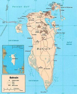
Bahrain (बहरीन) is a small island country situated near the western shores of the Persian Gulf. It is an archipelago with Bahrain Island the largest land mass at 55 km long by 18 km wide. The second largest island is Muharrak where Bahrain International Airport is also located.
Variants
- Bahrein (Anabasis by Arrian, p. 409.)
- Bahrain Island
- Tylos (Pliny.vi.32)
- Arabian : مملكة البحرين (मुम्लिकत अल-बहरईन)
Location
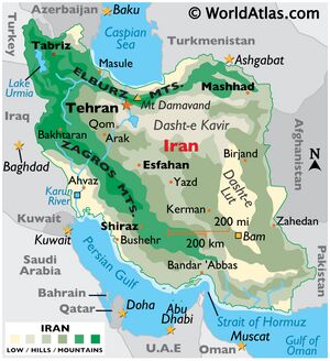
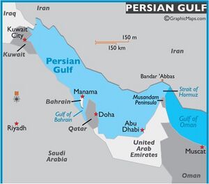
Saudi Arabia lies to the west and is connected to Bahrain by the King Fahd Causeway while Iran lies 200 km to the north across the Persian Gulf. The peninsula of Qatar is to the southeast across the Gulf of Bahrain. The planned Qatar Bahrain Causeway will link Bahrain and Qatar and become the world's longest marine causeway.
Jat Gotras Namesake
- Tahlon = Tylos (Bahrain) (Pliny.vi.32)
- Bahar = Bahrain = Tylos (Pliny.vi.32)
Jat Gotras Namesake
- Bahar = Bahrein (Anabasis by Arrian, p. 409.)
Mention by Pliny
Pliny [1] mentions Arabia.... Fifty miles from the coast, lying in the interior, is the region of Attene, and opposite to Gerra is the island of Tylos18, as many miles distant from the shore; it is famous for the vast number of its pearls, and has a town of the same name; in its vicinity there is a smaller island,19 distant from a promontory on the larger one twelve miles and a half. They say that beyond this large islands may be seen, upon which no one has ever landed: the circumference of the smaller island is one hundred and twelve miles and a half; and it is more than that distance from the Persian coast, being accessible by only one narrow channel.
18 The modern island of Bahrein, according to Brotier, still famous for its pearl-fishery.
Etymology
In Arabic, Bahrayn is the dual form of bahr ("sea"), so al-Bahrayn means "the Two Seas" although which two seas were originally intended remains in dispute. The term appears five times in the Qur'an, but does not refer to the modern island—originally known to the Arabs as Awal—but rather to the oases of al-Katif and Hadjar (modern al-Hasa). [2]It is unclear when the term began to refer exclusively to the Awal islands, but it was probably after the 15th century.
History

Bahrain is believed to be the site of the ancient land of the Dilmun civilization[3] and later came under the rule of successive Parthian and Sassanid Persian empires. The country was one of the earliest areas to convert to Islam in 628 AD.
Inhabited since ancient times, Bahrain occupies a strategic location in the Persian Gulf. It is the best natural port between the mouth of the Tigris, Euphrates Rivers and Oman, a source of copper in ancient times. Bahrain may have been associated with the Dilmun civilisation, an important Bronze Age trade centre linking Mesopotamia and the Indus Valley.[4] It was later ruled by the Assyrians and Babylonians.[5] It came under the control of Persians,[6] and then Arabs, under whom the island first became Nestorian Christian and then Islamic.
From the 6th to 3rd century BC, Bahrain was added to the Persian Empire by the Achaemenian dynasty. By about 250 BC, the Parthians brought the Persian Gulf under its control and extended its influence as far as Oman. During the classical era, the island's Hellenic name was Tylos, named when Nearchus discovered it while serving under Alexander the Great during Alexander's Asia campaign.[7] In order to control trade routes, the Parthians established garrisons along the southern coast of the Persian Gulf.[8]In the 3rd century AD, Ardashir I, the first ruler of the Sassanid dynasty, marched on Oman and Bahrain, where he defeated Sanatruq the ruler of Bahrain.[9]At this time, Bahrain comprised the southern Sassanid province along with the Persian Gulf's southern shore.
The Sassanid Empire divided their southern province into the three districts of Haggar (now al-Hafuf province in Saudi Arabia), Batan Ardashir (now al-Qatif province in Saudi Arabia) and Mishmahig (which in Middle-Persian/Pahlavi means "ewe-fish") which is present-day Bahrain.[10] Early Islamic sources describe the country as inhabited by members of the Abdul Qais, Tamim, and Bakr tribes who worshipped the idol Awal, from which the Arabs named the island of Bahrain Awal for many centuries.[11]However, Bahrain was also a center of Nestorian Christianity, including two of its bishoprics.
Connections with Dwarka
The seal (mudra) found in underwater excavation at Bet Dwarka corroborates the use of seals by citizens when Dvaraka was attacked by Salva, king of Saubha (Ref: Harivamsa, Bhavishaya Parva). It was used as a sort of identity card for citizens and to prevent the enemy from entering the city. The text says that it was the duty of the guards to check the identity. The seal also suggests trade and cultural contacts with Bahrain where Indus weights and Bahrain seals with Indus
[p.64]: motif and script as well as Lustrous Red Ware are found. The protohistoric sites in Bahrain were swallowed by the sea during the same period as Dvaraka was submerged (Larsen in Bahrain Through the Ages).
The inscription on the votive vessel confirms that the citizens of Dvaraka were literate and spoke Sanskrit. The occurrence of the Old Persian word "shah" may indicate the presence of foreigners at this important town. It further suggests that the Sea God Varuna was worshipped as there is a reference to him in the Epic etc. The various types and sizes of stone anchors with three holes found in large numbers in Dvaraka waters and the mooring station, at Dvaraka, discovered in the Arabian Sea prove beyond doubt the extensive overseas trade of the port of Dvaraka. The triangular 3-holed stone anchors of Dvaraka are similar to those of the 14th-12th century BC. Anchors of Cyprus and Syria (Rao S.R. 1990, 59-98 and Frost H. 1985). Such anchors must have had a much earlier origin in the Indian ports of Late Harappan days as attested by a Harappan seal depicting a triangular anchor (Konishi, M.A. 1985, 148). The triangular Lothal anchor had a single hole. By 1800 or 1700 B.C. three-holed anchors must have been invented in India. What is rather baffling is that while triangular anchors are found in Dwarka waters we are yet to find them in Bet Dwarka waters. They may be lying buried deep in the mud flats which are yet to be excavated.[12]
Jat settlements in Islamic countries
Giving an account of the Jats’ settlement in Persia, Qazi Athar Mubarakpuri had stated that they had been living in this region since a long time and they had developed many big and flourishing towns of their own as we are informed by Ibn-i-Khurdazbeh (d.893AD) that at about sixty miles away from the city of Ahwaz, there is a big city of the Jats, which is known after them as al-Zutt. [13] Another geographer of the same period had also observed that in the vicinity of Khuzistan there was a grand city Haumat al-Zutt. [14] These evidences given by the eminent author are enough to suggest that the Jats who settled in Persia gradually built up their economic resources and made significant contribution to urbanization of that country. [15]
The studies of Qazi Athar Mubarakpuri also bring to light that the Jats did not remain confined to Persia. They got settlement in different Parts of Arab land, which was under the Persian rule in those days. The Arab geographers testified that fact that in the coastal region of the Persian Gulf from Ubullah to Bahrain they had many pockets of their population and that they engaged themselves in different kind of work including cattle breeding. [16], [17] It is also confirmed by the Arab historians that in pre Islamic period their largest concentration was found in Ubullah, a fertile and pleasant place near the city of Basrah. Their second big settlement was in Bahrain where they had been residing in large numbers prior to the period of Muhammad as we are informed by Al-Baladhuri and other historians [18] In the same way, there are clear evidences for their settlement in Yemen before the advent of Islam and their important role in socio- political life of those days Yemen. In the times of pious Caliphs when Persia and many parts of the Arab region (previously ruled by Persian and Roman Kings) came under the Muslim army and a number of them got converted to Islam also. It is confirmed by different historical and geographical works, as cited by Maulana Mubarakpuri that they had settled in large number in Antioc and coastal town of Syria under the patronage of the pious and Umayyad caliphate (Khilafat-e-Rashidah and Banu Umayyad) [19], [20]
A very important and useful information that comes forth through the researches of Maulana Mubarakpuri is that the people of Makkah and Madinah in the times of Muhammad were not only familiar with the Indians, the Jats were also well known to them. On the authority of Sirat-i-Ibn-i-Hisham, Maulana has stated that once some people came from Najran to Madinah. Looking at them, Muhammad asked who are they ? They are just like Indians. [21], [22]
These Indians were assumed to be Jats (Zutt). In the same way, it is recorded in Jami-i-Tirmezi, the well known collection of Hadith that the famous Sahabi Sazrat Abdullah Ibn Masood once saw some persons in the company of Muhammad in Makkah, he observed that their hair and body structure is just like the Jats. There are also some other references in the Arabic source to the existence of the Jats in Madinah in that period. They also included a physician (Tabib) who was once consulted during the illness of Aisha, the wife of Muhammad. [23]
It is very interesting that we come to know through the studies of Maulana Mubarakpuri that the Jats residing in Bahrain, Yemen and other coastal regions in a large number had influenced the local Arabs by their language to such extent that the latter lost the originality and eloquence of their language. For the same reason the language of the people of the tribes of Banu Abd Qais and Azd was declared to be diluted and unauthentic due to their mingling and frequent interaction with Persian and Indian people. [24], [25]
बहरीन
बहरीन (अरबी : مملكة البحرين मुम्लिकत अल-बहरईन) जंबुद्वीप के अरबखंड में स्थित एक देश है। ये एक द्वीप पर बसा हुआ है - विस्तार में दिल्ली राज्य से भी छोटा। बहरीन १९७१ में स्वतंत्र हुआ और संवैधानिक राजतंत्र की स्थापना हुई, जिसका प्रमुख अमीर होता है। १९७५ में नेशनल असेंबली भंग हुई, जो अब तक बहाल नहीं हो पाई है। १९९० में कुवैत पर इराक के आक्रमण के बाद बहरीन संयुक्त राष्ट्रसंघ का सदस्य बना ।ये अरब जगत का एक हिस्सा है, इसकी राजधानी है मनामा। स्था्नीय भाषाओं में इसको बहरैन कहते हैं। यह खाड़ी के अन्य तमाम देशों की तरह शिया-सुन्नी इस्लाम की राजनीति के बीच खड़ा है। यहां शिया बहुलता, भावना और सुन्नी शासन है ।
इतिहास: बहरीन का एक लंबा इतिहास है जो कम से कम 5000 साल पहले की तारीख में ले जाता है, उस समय यह क्षेत्र मेसोपोटामिया और सिंधु घाटी, भारत के बीच एक व्यापार केंद्र के रूप में कार्य करता था। बहरीन में विकसित होने वाली सभ्यता उस समय दिलमुन सभ्यता थी। 600 ईसापूर्व में, यह क्षेत्र बेबीलोन साम्राज्य का हिस्सा बन गया।
शुरुआती सालों के दौरान, 7 वीं शताब्दी तक बहरीन को टाइलोस के रूप में जाना जाता था।
1830 के दशक में, अल खलीफा परिवार ने यूनाइटेड किंगडम के साथ एक संधि पर हस्ताक्षर किए जाने के बाद बहरीन ब्रिटिश संरक्षित बन गया, जिसने तुर्क तुर्की के साथ सैन्य संघर्ष की स्थिति में ब्रिटिश सुरक्षा की गारंटी दी। 1 9 35 में, ब्रिटेन ने बहरीन में फारस की खाड़ी में अपना मुख्य सैन्य आधार स्थापित किया लेकिन 1968 में, ब्रिटेन ने बहरीन और अन्य फारसी खाड़ी शेकोडो के साथ संधि के अंत की घोषणा की। नतीजतन, बहरीन अरब अमीरात का संघ बनाने के लिए आठ अन्य शेकोडोम में शामिल हो गए। हालांकि, 1971 तक, उन्होंने आधिकारिक तौर पर एकीकृत नहीं किया था और बहरीन ने 15 अगस्त, 1971 को खुद को स्वतंत्र घोषित कर दिया था।
1973 में, बहरीन ने अपनी पहली संसद चुनी और एक संविधान का मसौदा तैयार किया लेकिन 1975 में संसद को तोड़ दिया गया जब उसने अल खलीफा परिवार से सत्ता हटाने की कोशिश की जो अभी भी बहरीन की सरकार की कार्यकारी शाखा बना हुआ है। 1990 के दशक में, बहरीन ने शिया बहुमत से कुछ राजनीतिक अस्थिरता और हिंसा का अनुभव किया और नतीजतन, सरकारी कैबिनेट में कुछ बदलाव हुए। इन परिवर्तनों ने शुरुआत में हिंसा समाप्त कर दी लेकिन 1996 में कई होटल और रेस्तरां पर हमला किया गया और देश तब से अस्थिर रहा है.
अर्थव्यवस्था और भूमि उपयोग: बहरीन में कई बहुराष्ट्रीय कंपनियों के साथ एक विविध अर्थव्यवस्था है। बहरीन की अर्थव्यवस्था का एक बड़ा हिस्सा हालांकि तेल और पेट्रोलियम उत्पादन पर निर्भर करता है। बहरीन के अन्य उद्योगों में एल्यूमीनियम गलाने, लोहे की गोली, उर्वरक उत्पादन, इस्लामी और ऑफशोर बैंकिंग, बीमा, जहाज की मरम्मत और पर्यटन शामिल हैं। कृषि केवल बहरीन की अर्थव्यवस्था का लगभग एक प्रतिशत का प्रतिनिधित्व करता है लेकिन मुख्य उत्पाद फल, सब्जियां, कुक्कुट, डेयरी उत्पाद, झींगा और मछली हैं।
भूगोल: बहरीन मध्य पूर्व, फारस की खाड़ी में सऊदी अरब के पूर्व में स्थित है। यह एक छोटा सा राष्ट्र है जिसका 760 वर्ग किमी का कुल क्षेत्रफल है जो कई अलग-अलग छोटे द्वीपों में फैला हुआ है। बहरीन में अपेक्षाकृत सपाट स्थलाकृति है जिसमें रेगिस्तानी मैदान है।
बहरीन के मुख्य द्वीप के मध्य भाग में निम्न ऊंचाई एस्केपमेंट है और देश में उच्चतम बिंदु जबल दुखन 400 फीट (122 मीटर) है। बहरीन का वातावरण शुष्क है और इस तरह हल्के सर्दियों और बहुत गर्म, आर्द्र ग्रीष्म ऋतु होते हैं। देश की राजधानी और सबसे बड़ा शहर, मनामा का औसत जनवरी औसत तापमान 14˚C है और औसत अगस्त उच्च तापमान 38˚C है।
External links
References
- ↑ Natural History by Pliny Book VI/Chapter 32
- ↑ Houtsma, M. Th (1960). "Baḥrayn". Encyclopedia of Islam I. Leiden: E.J. Brill. p. 941.
- ↑ Oman The Lost Land, Written by John Lawton
- ↑ Qal’at al-Bahrain – Ancient Harbour and Capital of Dilmun
- ↑ Larsen, Curtis E. (1984). Life and Land Use on the Bahrain Islands: The Geoarchaeology of an Ancient Society. University of Chicago Press. pp. 52–55. ISBN 978-0-226-46906-5.
- ↑ Mojtahed-Zadeh & 1999, p. 119.
- ↑ Larsen, Curtis E. (1984). Life and Land Use on the Bahrain Islands: The Geoarchaeology of an Ancient Society. University of Chicago Press. pp. 52–55. ISBN 978-0-226-46906-5.
- ↑ Federal Research Division (2004). Bahrain. Kessinger Publishing. ISBN 978-1-4191-0874-7
- ↑ Hoyland, Robert G. (2001). Arabia and the Arabs: From the Bronze Age to the Coming of Islam. Routledge. p. 28. ISBN 978-0-415-19535-5
- ↑ Hoyland, Robert G. (2001). Arabia and the Arabs: From the Bronze Age to the Coming of Islam. Routledge. p. 28. ISBN 978-0-415-19535-5
- ↑ Al-Tajir, Mahdí Abdalla (1982). Language and Linguistic Origins in Baḥrain: The Baḥārnah Dialect of Arabic. Taylor & Francis. pp. 16, 29. ISBN 978-0-7103-0024-9
- ↑ Dr. S. R. Rao:From Dvaraka to Kurukshetra, Journal Of Marine Archaeollgy, Vol 5-6 (1995-1996),p.63-64
- ↑ Ibn Khurdazbeh , op.cit , p. 43
- ↑ Al-Istakhari, op, cit. , p. 94
- ↑ Zafarul Islam: Qazi Athar Mubarakpuri’s Studies on Jats, The Jats, Vol. II, Ed. Dr Vir Dingh, Delhi, 2006. p. 27
- ↑ Al Baladhrui, Futuh al-Buldan, al Matba al-Misriah, Cairo , 1932 pp. 166,367,369
- ↑ Qazi Athar, P.66
- ↑ Al Tabari, Tarikh-i-Tabari. Barul Maarif, Cairo 1962, III/304
- ↑ Qazi Athar, pp, 66-67
- ↑ Zafarul Islam: Qazi Athar Mubarakpuri’s Studies on Jats, The Jats, Vol. II, Ed. Dr Vir Singh, Delhi, 2006. p. 27
- ↑ Ibn Hisha, Sirat al-Nabi, Darul Fikr, Cairo (n.d.) iv/264
- ↑ Zafarul Islam: Qazi Athar Mubarakpuri’s Studies on Jats, The Jats, Vol. II, Ed. Dr Vir Singh, Delhi, 2006. p. 28
- ↑ Zafarul Islam: Qazi Athar Mubarakpuri’s Studies on Jats, The Jats, Vol. II, Ed. Dr Vir Singh, Delhi, 2006. p. 28
- ↑ Qazi Athar, p. 69
- ↑ Zafarul Islam: Qazi Athar Mubarakpuri’s Studies on Jats, The Jats, Vol. II, Ed. Dr Vir Singh, Delhi, 2006. p. 29
Back to Jat Places in Foreign

