Ramtek
| Author:Laxman Burdak, IFS (R) |


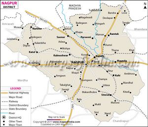
Ramtek (रामटेक) is a town and tahsil in Nagpur district of Maharashtra. Its ancient name was Ramagiri (रामगिरि).
Variants of name
- Ramateka (रामटेक) (AS, p.789)
- Ramagiri रामगिरि (1) = Ramtek रामटेक AS, (p.788)
- Tapogiri तपोगिरि = Ramtek (रामटेक) (जिला नागपुर, माह.) (AS, p.389)
- Sinduragiri सिंदूरगिरि = Ramtek रामटेक पहाड़ियाँ, (AS, p.957)
- Shaivalagiri शैवालगिरि = Ramtek रामटेक (AS, p.911)
- Tapamgiri तपंगिरि = L.22, 27 of Ramtek stone inscription of Ramachandra. [1]
Origin
Ramtek derives name from temple of Rama situated on hill close to the town.[2]
Location
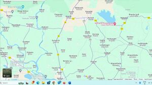
It is located at a distance of around 50 km from Nagpur. Khindasi lake is one of the important tourist attractions at Ramtek. Ramtek is a Town in Ramtek Taluka in Nagpur District of Maharashtra State, India. It belongs to Vidarbh region . It belongs to Nagpur Division . Ramtek Pin code is 441106 and postal head office is Ramtek. Soneghat ( 3 KM ) , Chargaon ( 5 KM ) , Bhilewada ( 5 KM ) , Chichala ( 6 KM ) , Nagardhan ( 6 KM ) are the nearby Villages to Ramtek. Ramtek is surrounded by Parseoni Taluka towards west , Mouda Taluka towards South , Kamptee Taluka towards South , Mohadi Taluka towards East.[3]
Villages in Ramtek tahsil
Villages:
1 Ajani, 2 Akola, 3 Ambazari, 4 Amgaon, 5 Asoli, 6 Bandra, 7 Belda, 8 Bhandar Bodi, 9 Bhilewada, 10 Bhojapur, 11 Bhondewada, 12 Bijewada, 13 Bondri, 14 Borda, 15 Bori, 16 Bothiya, 17 Chargaon, 18 Chargaon, 19 Chaugan, 20 Chawari, 21 Chhatrapur, 22 Chichala, 23 Chichda, 24 Chiknapur, 25 Chokhala, 26 Chorbahuli, 27 Chorbahuli, 28 Chorkhumari, 29 Dahoda, 30 Deolapar, 31 Deoli, 32 Devhada, 33 Dongartal, 34 Dongri, 35 Dudhala, 36 Dulara, 37 Fulzari, 38 Fulzari, 39 Garra, 40 Ghoti, 41 Ghoti, 42 Ghoti, 43 Goreghat, 44 Gudegaon, 45 Guguldoh, 46 Hamlapuri, 47 Hasapur, 48 Hatodi, 49 Hetitola, 50 Hiwara, 51 Hiwara, 52 Hiwara, 53 Hiwara, 54 Jamuniya, 55 Junewani, 56 Kachurwahi, 57 Kadbikheda, 58 Kamthi, 59 Karwahi, 60 Katta, 61 Kawadak, 62 Kawalapur, 63 Khairi, 64 Khandala, 65 Khanora, 66 Khapa, 67 Kharpada, 68 Khidki, 69 Khindsi, 70 Khodegaon, 71 Khumari, 72 Khursapar, 73 Kirnapur, 74 Kirnapur, 75 Lakhapur, 76 Lodha, 77 Lohadongari, 78 Lohara, 79 Mahadula, 80 Maharajpur, 81 Manapur, 82 Mandri, 83 Manegaon, 84 Manegaon, 85 Manegaon Tek, 86 Mangli, 87 Mansar, 88 Masala, 89 Minsi, 90 Moudi, 91 Mukanapur, 92 Murda, 93 Murzad, 94 Musewadi, 95 Nagardhan, 96 Nahabi, 97 Navegaon, 98 Navegaon, 99 Nawargaon, 100 Nawegaon, 101 Panchala, 102 Panchala, 103 Parsoda, 104 Patgowari, 105 Pathrai, 106 Pauni, 107 Pauni, 108 Pendhari, 109 Pindkapar, 110 Pindkapur, 111 Pipriya, 112 Pipriyapeth, 113 Pusda, 114 Ramjam, 115 Rampuri, 116 Sagrampur, 117 Salai, 118 Salai, 119 Salaimeta, 120 Sarakha, 121 Saundani, 122 Sawangi, 123 Sawara, 124 Shahapur, 125 Shivani, 126 Sillari, 127 Sindewani, 128 Sirpur, 129 Sitalwadi, 130 Sitapur, 131 Sitapur, 132 Soneghat, 133 Sonpur, 134 Tangla, 135 Totaladoh, 136 Tuyapar, 137 Tuyapar, 138 Umri, 139 Umri, 140 Usripar, 141 Wadamba, 142 Wadamba, 143 Wadegaon, 144 Warghat, 145 Zinzariya,
Source - https://www.census2011.co.in/data/subdistrict/4028-ramtek-nagpur-maharashtra.html
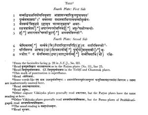
Ramtek Plate of Pravarasena II
This plate belongs to a set of about five copper-plates which was discovered a few years ago by some contractors while digging for manganese at Mansar near Ramtek, about 28 miles from Nagpur. The contractors divided the plates among themselves. After some of them had left the province, the news of the discovery reached Mr. G. P. Dick, Barrister-at-Law of Nagpur, who could consequently recover only one of the plates. It was in his possession until his departure for England. Subsequently, it seems to have been lost. Dr. Hiralal, to whom impressions and photographs of the plate were sent soon after it was discovered, gave a short account of it in his Inscriptions in C.P. and Berar (second edition), pp. 4-5. As the plate was unpublished, I requested Dr. Hiralal to send its ink impressions to me. He complied with my request, but the impressions were lost in transit. He subsequently sent me its photographs, from which I edited it with facsimiles in the Nagpur University Journal, No. III, pp. 20-21. I edit it here from the same facsimiles.
As shown below, the present plate records a Vakataka grant. A Vakataka copperplate inscription generally consists of five plates. Of them, the first two contain the genealogy of the donor, commencing from his ancestor Pravarasena I. On the third plate are generally given the particulars about the grant — the occasion on which it was made, the name, gotra etc. of the donee, the name of the village, its boundaries, etc. The fourth plate enumerates the conditions of the grant and the immunities allowed to the donee. This is followed by the usual benedictive and imprecatory verses, the regnal year when the grant was made and the names of the writer and the Dutaka, which occupy the fifth plate. The present plate, which contains an enumeration of the immunities, is, therefore, the fourth or penultimate plate of its set. The photographs sent by Dr. Hiralal measure 5.6" by 3.1". About 1.3" from the proper right end of them there is a round hole, 0.3 in diameter, for the ring which must have originally held the plates together. As the scale of the photographs is not known, it is not possible to state the exact dimensions of the original plate. Judged by the photographs which have considerably faded, the plate seems to have been in a good state of preservation, only two or three letters in the last two lines being slightly damaged by rust. There are five lines on either side. The fifth line on the first side is somewhat shorter than the rest as there was no sufficient space for more letters in the lower proper left corner.
The characters are of the box-headed variety of the southern alphabets and closely resemble those of the other grants of Pravarasena II. The only peculiarities worth noticing are that (i) the medial au, which is generally bipartite in Vakataka records, is shown by two curves in pautra, line 7, the curve on the right hand being wrongly made to turn to the left; (ii) the sign for the medial ī (long) is a curling curve generally turning to the left (cf. kshira-, line 4), but in bhunjitah (for bhunjatah) in lines 7-8, it turns to the right; (iii) the signs for the jihvāmuliya and upadhmaniya occur in lines 4 and 8 respectively. The language is Sanskrit, and the extant portion is wholly in prose. As will be seen from the transcript given below, the record has been written very incorrectly and carelessly. Absence of sandhis, omission of the visarga, the use of n for ṇ and of incorrect grammatical forms like kuryyāt and kārayitā are some of the glaring mistakes. Similar mistakes are, however, noticed in all Vakataka grants. The scribe has omitted some words at the end of line 1 and several more after atm-ānugrahāya in line 3 as shown below in the notes to the transcribed text.
[p.74]: As the first three plates are not forthcoming now all important particulars such as the names of the donor and the donee, the land or the village granted, its boundaries etc. are lost. But as the characters of the present plate resemble those of the Patna Museum and other plates of the Vakataka king Pravarasena II, the present grant also was probably made by him. The opening words of the extant portion state that it was made for the increase of religious merit, life, strength and prosperity of the donor. This statement clearly shows that the present plate could not have belonged to the same set as the Patna Museum plate which records a gift for the increase of the religious merit of Pravarasena II’s mother. The subsequent portion records the usual immunities granted in respect of agrahāra villages. Except for certain variants, they are identical with those which usually figure in Vakataka copperplate inscriptions. The concluding lines convey the royal order that none should cause an obstacle in the enjoyment of the gift, but that it should by all means be protected and augmented. This was followed by the usual warning, only a part of which appears on the present plate, that whoever, disobeying the royal order, would cause the slightest hindrance, would receive condign punishment, if reported against by the Brahmanas. In the absence of the last plate, it is not possible to state the names of the writer and the Dutaka nor the regnal year when the grant was made.
The plate does not make any addition to our historical information; for the formal part of the grant which is preserved on the present plate is common to several other Vakataka inscriptions.


[p.75]: (Our Officers of noble birth) who are employed by the order of the Sarvādhyaksha (General Superintendent) and who exercise their authority by (Our) command, (Our soldiers and policemen) should be directed by the following order which is already well-known to them
(The subsequent plates of the grant are not forthcoming.)
Ramtek stone inscription of Ramachandra
Source - 1. Mirashi and L.R. Kulkarni, Epigraphia Indica, Vol. XXV, 1939-40, pp.7-20
[p.7]: The place is regarded as very holy on account of a number of temples and tirthas on the hill and in its vicinity. The sanctity of the place can be traced back to the fourth century AD at least; for the Riddhapur plates, which were issued from the foot-prints of the Lord of Ramagiri1 (modern Ramtek) , record a grant of Vakataka dowager queen Prabhavatigupta on the 12th tithi of the bright fortnight of kartikka. Kalidasa also records in his Meghaduta that the hill was marked with the foot-prints of Rama.2 These references indicate that the shrine at Ramagiri at first contained only the foot-prints of Rama. Later on images of Rama and Sita appear to have been installed there and another temple dedicated to Lakshamana was built. ....The present inscription is incised on a large slab let into the wall on the right hand side of the door of garbhagriha in the temple of Lakshamana.
1. रामगिरि स्वामिन पादमूलाद 2. वग्द्दै: पुंसां रघुपति पदैरंकितं मैखलाषु (verse 12)
[p.8]: ....The fifth line contains the words Yadavo vamshah and Yadu-vamshajah indicating that the reining king called himself Yadava and traced his descent from the legendary hero Yadu. The exploits of some king of this family are next described, but only names of his adversaries that can be made out are Rudra (रूद्र) in L.7, the lord of Andhras and Choda in L.8 and possibly the lord of Gurjaras in L.9 and Jaitrapala (जैत्रपाल) in L.9 . The name of Simhana (सिंहण) appears in L.15 in the course of description of his successor. L.16 mentions genealogy of some person named Shri-Raghava (श्री राघव). He was a descendant of one Vayinayaka (वायिनायक). From L.17 we learn that the king, the illustrious Ramachandra, bestowed on him (ie Raghava) fortune....This Raghava is probably referred to again in LL 18,21 as Shaiyaapala (gradian of the royal bed-chamber). His wife Rajayi (राजायी) is mentioned in L.19.....The record describes the hill and temples on the four sides of it viz., Ghanteshvara (घंटेश्वर) (L.28), Sudheshvara (सुधेश्वर) (L.28), Kedara (केदार) (L.28) and Anjaneya (आंजनेय) (L.28).
[p.9]: .....
[p.10]: We find the names of Jaitrapala, Simhana and Ramachandra in the genealogical list of the later Yadavas of Devagiri, who flourished in 12-13th centuries. ...The kingdom of Yadavas extended as far as Lanji3 in Balaghat which mentions the Yadava king Ramachandra. As no successor of Ramachandra has been mentioned, it seems that the inscription was put up during his reign. It may, therefore, be referred to the last quarter of 13th century AD.....
The hill on which the main temples of Rama and Lakshamana are situated is called Sinduragiri (सिंदूरगिरि) and Tapamgiri (L.22, 27) (for Tapogiri) (तपोगिरि) in the present inscription. Hill called Sinduragiri because it was reddened by the blood flowing from breast of Hiranyakashipu which was torn by Narasimha with his sharp claws. There are two temples on the hill containing huge images of man-lion incarnation of Vishnu. As conjectured by Counsens[4] the name Sinduragiri may have been given originally to the hill because of its red stones which when broken or newly dressed appeared blood-red.
The second name Tapogiri (penance-hill) (तपोगिरि) occurs in its tradition due to Shambuka (शम्बूक) (L.45), a shudra ascetic, practiced penance here. He was afterward killed by Rama with his sword called Chandrahasa (चंद्रहास) (L.45).
[p.11]: The story of Shambuka also occurs in Ramayana of Valmiki. According to the epic the Shudra ascetic was engaged in austerities in on the bank of a large lake to the north of mount Shaivalagiri (शैवालगिरि). ....It would not be wrong to identify Ramtek with the Shaivala mountain.
Wiki editor Notes
- Jaitwar (Jat clan) = Jaitrapala (जैत्रपाल) (L.9). Jaitrapala (जैत्रपाल) (L.9) an adversary king of Ramachandra of Yaduvanshi origin, is mentioned in Ramtek stone inscription of Ramachandra. [5]
- Shaival (Jat clan) = Shaivalagiri (शैवालगिरि). The story of Shambuka occurs in Ramayana. According to the epic the Shudra ascetic was engaged in austerities in on the bank of a large lake to the north of mount Shaivalagiri (शैवालगिरि). ....It would not be wrong to identify Ramtek with the Shaivala mountain. Mirashi and L.R. Kulkarni, Epigraphia Indica, Vol. XXV, 1939-40, p.11
- Singana (Jat clan) = Simhana (सिंहण) (L.15). Simhana (सिंहण) (L.15), an adversary king of Ramachandra of Yaduvanshi origin, is mentioned in Ramtek stone inscription of Ramachandra. [6]
- Sura (Jat clan) = Sur River (सुरनदी) (L.39). Sur River (सुरनदी) (L.39) is mentioned in Ramtek stone inscription of Ramachandra [7]
History

Riddhapur plates of 19th year reignal year of Prabhavatigupta mentions this place as Ramagiri (रामगिरि). [9]
Ramagiri is undoubtedly modern Ramtek, about 28 miles north of Nagpur. It lies only about 3 miles from Nandivardhana, modern Nagardhan, the earlier capital of the Vâkàtakas. In Kâlidasa's Meghadûta, Râmagiri is mentioned as the place where the Yaksha, exiled from Alakā, lived for a year. From the description in Kālidāsa's poem we learn that the hill was marked by the vénérable foot-prints of Raghupati (Ramachandra), and it is noteworthy that the present grant was made by Prabhâvatîguptâ near the foot-prints of the Lord of Râmagiri. The geographical situation of Râmtek answers to the description of Râmagiri in the Meghadûta and it is known to have been regarded as a holy place for several centuries. There should therefore be no doubt about this identification. Several grants of Prabhâvatîguptâ and Pravarasena II were made after being offered to the Bhagavat who was plainly none but the god Râmachandra whose pàdukâs were installed at Râmagiri.
Ramtek has got Historic temple of lord Rama. It is believed that Ramtek was the place where Rama, the Hindu god, rested while he was in exile. This place is also famous for its relation with Great poet Kalidasa. Kalidasa has written Meghdootum in hills of Ramtek. Late Indian Prime Minister Mr. Narsimha Rao contested his election from Ramtek Constituency.
Inscription found at Ramtek show that during the 12th century AD Nagpur and its surrounding regions formed the part of the thickly wooded country called Jhadimandala under Yadavas of Devagiri.[10]
Religious significance
Ramtek hosts a historic temple of Rama. It is believed that Ramtek was the place where Rama, Sita and Lakshmana had rested while in exile, Hence it is named Ramtek. It is also known as Sinduragiri. [11] [12]
According to Hindu history, the ashram of the Hindu sage Agastya was situated close to Ramtek. The present temple was built by Raghuji Bhonsale, the Maratha ruler of Nagpur in 18th century after his victory over fort of Deogarh in Chhindwara.
This place is also related to the Sanskrit poet Kalidasa. It is believed that Kalidasa wrote Meghadūta in the hills of Ramtek.
Jain Temple
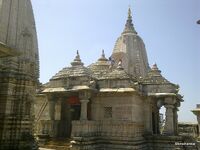
Ramtek is also known for its ancient Jain temple with various ancient statues of Jain Tirthankara. The main idol of Shantinatha, the sixteenth Tirthankara has a legend associated with it.
It became more popular when one of the leading Digambar Jain Acharyas, Acharya Vidyasagar visited and stayed with his sangh in Ramtek in 1993, 94, 2008, 2013 and 2017 for the four months of chaturmas during the rainy season. With his inspiration, a big Jain temple has been constructed.
The place was ruled by Gond rulers before being captured by the Bhonsale rulers of Nagpur in the eighteenth century.
Sulanadi vs Sura River
The Sulanadi (सूलनदी) (L.15), on the bank of which it lay, is probably identical with the river Sur2 which flows only about 4 miles east of Nagardhan. (p.615)[13]
2. This river is called Sura-nadi in L.39 of the Ramtek stone inscription of Ramachandra, Ep Ind Vol XXV, p 10. The name of the river seems to have changed from Sula-nadi to Sura-nadi in the course of the seven centuries that separate these two records[14]
रामटेक
रामटेक (AS, p.789): विजयेन्द्र कुमार माथुर[15] ने लेख किया है .....रामटेक महाराष्ट्र राज्य के नागपुर से 20 मील की दूरी पर रमणीक और ऊंची पहाड़ियों पर स्थित है। कुछ विद्वानों के मत में यह महाकवि कालिदास के 'मेघदूत' में वर्णित रामगिरि है। यहाँ विस्तीर्ण पर्वतीय प्रदेश में अनेक छोट-छोटे सरोवर स्थित हैं, जो शायद 'पूर्वमेघ' में उल्लिखित 'जनकतनया स्नान पुण्योदकेषु' में निर्दिष्ट जलाशय हैं। किंवदंती है कि वनवास काल में राम, लक्ष्मण तथा सीता इस स्थान पर रहे थे। रामचंद्र जी का एक सुंदर मंदिर ऊंची पहाड़ी पर बना हुआ है। मंदिर के निकट विशाल वराह की मूर्ति के आकार में कटा हुआ एक शैलखंड स्थित है। रामटेक को सिंदूरगिरि भी कहते हैं। इसके पूर्व की ओर 'सुरनदी' या 'सूर्यनदी' बहती है। इस स्थान पर एक ऊंचा टीला है, जिसे गुप्तकालीन बताया जाता है। चंद्रगुप्त द्वितीय की पुत्री प्रभावती गुप्त ने रामगिरि की यात्रा की थी। इस तथ्य की जानकारी रिद्धपुर के ताम्रपत्र लेख से होती है। प्राचीन जनश्रुति के अनुसार रामचंद्र जी ने शंबूक का वध इसी स्थान पर किया था।
सिंदूरगिरि
सिंदूरगिरि (AS,p.957): = रामटेक जिला नागपुर महाराष्ट्र की पहाड़ियों का एक नाम है. इन पहाड़ियों में लाल रंग का पत्थर मिलता है जिसका सिंदूर का सा वर्ण है. किंवदंती है कि नृसिंह अवतार में हिरण्यकशिपु के रक्त से स्थान लाल रंग का हो गया था. [16]
तपोगिरि
विजयेन्द्र कुमार माथुर[17] ने लेख किया है ...तपोगिरि (AS, p.389) रामटेक) (जिला नागपुर, माह.) का प्राचीन नाम है। किंवदंती के अनुसार यह माना जाता है कि अपने वनवास काल में श्रीरामचन्द्र, सीता और अनुज लक्ष्मण के साथ यहाँ कुछ दिन ठहरे थे। यहाँ प्राचीन काल में अनेक तपस्वियों के आश्रम थे, जो इसके नामकरण का कारण है।
References
- ↑ Mirashi and L.R. Kulkarni, Epigraphia Indica, Vol. XXV, 1939-40, pp.7-20
- ↑ https://www.jainfoundation.in/JAINLIBRARY/books/epigraphia_indica_vol_25_032579_std.pdf, p.7
- ↑ http://www.onefivenine.com/india/villages/Nagpur/Ramtek/Ramtek
- ↑ PRAS, WC, for 1904-05, p.41, para 127
- ↑ Mirashi and L.R. Kulkarni, Epigraphia Indica, Vol. XXV, 1939-40, p.8
- ↑ Mirashi and L.R. Kulkarni, Epigraphia Indica, Vol. XXV, 1939-40, p.8
- ↑ Mirashi and L.R. Kulkarni, Epigraphia Indica, Vol. XXV, 1939-40, pp.7-20
- ↑ Hans Bakker (1990). The History of Sacred Places in India As Reflected in Traditional Literature: Papers on Pilgrimage in South Asia. BRILL. pp. 70–73. ISBN 90-04-09318-4.
- ↑ Corpus Inscriptionum Indicarum, Vol. V, 1963, pp.33-37:L.1 जित (त) भगवता ।। रामगिरिस्वामिन=पादमूलाद्गुप्तान (ना) मादि
- ↑ Nagpuronline-History
- ↑ "Ramtek: A Secret Getaway in Maharashtra". Outlook India.
- ↑ Aitihasik Sthanavali by Vijayendra Kumar Mathur, p.789
- ↑ Corpus Inscriptionium Indicarium Vol IV Part 2 Inscriptions of the Kalachuri-Chedi Era, Vasudev Vishnu Mirashi, 1905, p.611-617
- ↑ Mirashi and L.R. Kulkarni, Epigraphia Indica, Vol. XXV, 1939-40, pp.7-20
- ↑ Aitihasik Sthanavali by Vijayendra Kumar Mathur, p.789
- ↑ Aitihasik Sthanavali by Vijayendra Kumar Mathur, p.957
- ↑ Aitihasik Sthanavali by Vijayendra Kumar Mathur, p.389
Back to Maharashtra

