Sausar
| Author:Laxman Burdak, IFS (R) |


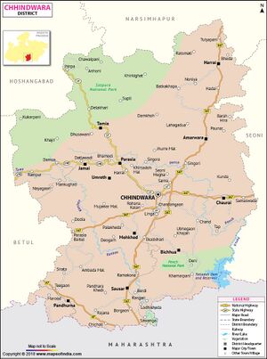
Sausar (सौसर) is a town and tahsil in Chhindwara district of Madhya Pradesh. Sausar lies in Vidharbha region, Nagpur is the center for all the economic activities in this region which is just 72 km from Sausar. More than 90 per cent of farmers produce oranges. Cotton is grown in large quantities in the local area.
Variants
- Saunsar (सौंसर)
Location
The area is a hotspot for manufacturers mainly due to its location as it lies just 10 km within MP state from Maharashtra and the highway is connected to every part of India as now it has been declared a National Highway 547. Maharashtra states winter Capital Nagpur lies at a distance of just 72 km and Bhopal lies at a distance of just 300 km and Chhindwara at 55 km.
Jat Gotras Namesake
- Sau (सऊ) (Jat clan) → Sausar (सौसर). Sausar (सौसर) is a town and tahsil in Chhindwara district of Madhya Pradesh.
Villages in tahsil
Towns: 1 Sausar, 2 Lodhikheda, 3 Mohgaon, 4 Piplanarayanwar, 5 Borgaon
Villages:
1 Alesur, 2 Ambakhapa, 3 Ambari, 4 Amla (F.V.), 5 Bairagarh, 6 Banabakoda, 7 Baradevi, 8 Bargabodi, 9 Belgaon, 10 Berdi, 11 Bhilapar, 12 Bhivadoni, 13 Bhudkum, 14 Bhudkum (F.V.), 15 Bhumma, 16 Bichhawi, 17 Bichuwa Baggu, 18 Bramhan Pipla, 19 Chhattrapur, 20 Chhindewani Dhadi, 21 Chikhali, 22 Chirkutaghondi, 23 Devo Bhagakta, 24 Dewli, 25 Dhoda Borgaon Mal., 26 Dhokdoh, 27 Dhotki, 28 Dudhala Khurd, 29 Dudhalakala, 30 Dukarjhela, 31 Gajandoh (F.V.), 32 Gangatwara, 33 Ghadela, 34 Ghadela Malaujan, 35 Ghoghari, 36 Ghogharikhapa, 37 Ghoti, 38 Gondiwadhona, 39 Gowariwadhona, 40 Gujarkhedi, 41 Haranberdi, 42 Hiwara Khanderaywar, 43 Hiwari, 44 Jakhiwara, 45 Jam, 46 Jamalapani No.1, 47 Jamalpani No.2, 48 Jamthi, 49 Jirola, 50 Jobandera (F.V.), 51 Jobani, 52 Kabarpipla, 53 Kadhiya No.1, 54 Kajalwani, 55 Kanhargaon, 56 Karli, 57 Karmakadi, 58 Khairipanthawali, 59 Khairitaygaon, 60 Khandseoni, 61 Khapa, 62 Khapa Karimwar, 63 Khapa Padriwar, 64 Khaparkheda, 65 Khayrinbadosa, 66 Khedijasodi, 67 Khutamba, 68 Kodadongri Mal., 69 Kondasawari, 70 Kondhar Dawami, 71 Kondhar Ryt., 72 Koparawadi Khurd, 73 Koprawadi Kalan, 74 Kuddam, 75 Lodhikheda, 76 Maherakhapa, 77 Malegaon, 78 Mangurli, 79 Marram, 80 Mathni, 81 Mehndi, 82 Mendhepathar, 83 Mogra, 84 Mohgaon, 85 Mungnapar, 86 Nandewani, 87 Nandudhana (F.V.), 88 Nauthal, 89 Nimni, 90 Palaspani, 91 Panchalkhapa, 92 Pandhara Khedi, 93 Pangdi, 94 Paradsinga, 95 Pareghat, 96 Partapur, 97 Pindrai, 98 Pipalgaon (F.V.), 99 Pipla Kanhan, 100 Ramakona, 101 Rampuri, 102 Ramudhana (F.V.), 103 Rangari, 104 Ranpeth Dawami, 105 Ranpeth Mal, 106 Razhadi Borgaon, 107 Razhadipipla, 108 Ridhora, 109 Rohna, 110 Sangam, 111 Sardoni Ryt., 112 Sarkikhapa, 113 Sarra Sawari, 114 Satnoor, 115 Sawanga, 116 Sawangi, 117 Sawarni Dawami, 118 Sawli No.1, 119 Saykheda, 120 Sayra, 121 Semra, 122 Silora, 123 Singpur, 124 Sitapar, 125 Sitapar, 126 Suriya Buriya, 127 Tinkheda, 128 Utekata, 129 Waghora, 130 Yalkapar,
Source - https://www.census2011.co.in/data/subdistrict/3656-sausar-chhindwara-madhya-pradesh.html
Geography
Sausar is located at 21.65°N 78.78°E in central India. It has an average elevation of 352 metres (1,154 feet). The Jam River and Kanhan Rivers are the main rivers in Sausar. The city is situated between the two rivers.
Author's visit
Author visited Sausar on 26.04.1989, 27.09.1989, 28.09.1989, 22.10.1989, 06.11.1989, 12.12.1989, 13.12.1989, 28-29.05.1990.

