
Chandrapur
| Author:Laxman Burdak, IFS (R) |


Chandrapur (चंद्रपुर) is a town and district in Maharashtra. The city’s name means “village of the Moon.” Chandrapur was the capital of the Gond dynasty from the 12th to the 18th century, and it was later conquered by the Maratha Bhonsles from Nagpur[1] Chandrapur is a fort city founded by Khandkya Ballal Shah, a Gond king of the 13th century.[2] The city sits at the confluence of the Erai river and Zarpat river.
Author (Laxman Burdak) passed through this town on 14-12-2007 while on Tour of South India by 2616 GT Express.
Variants
- Chandrapura चंद्रपुर 1. (जिला बनारस, उ.प्र.), 2. Chanderi चंदेरी, म.प्र., 3. Chanda चांदा, महा., (AS, p.318)
- Chanda/Chāndā चांदा, महा., (AS, p.318) (earlier known as Chanda, the official name until 1964)
- Lokapura (लोकपुरा)
- Indura (इन्दूर)
- Indupur/Indupura
- Chanda District
- Chandrapura Sangamika (चंद्रपुर संगमिक) in Dudia Plates of 23rd year of Pravarasena II[3]
Location
Chandrapur district is surrounded by Gadchiroli district in the east, Gondia district in north-east Bhandara, Nagpur and Wardha districts in north, Yavatmal district in west Telangana state in south.
Etymology
The local people relate the name "Chandrapur" to the words Chandra (the moon) and pur (a settlement) after a legend. Scholars see the name as a derivative of "Indupur" (city of the moon) which stood near the Jharpat in the Treta Yuga.
Geography
Chandrapur is located in central India in the eastern part of Maharashtra state at 19.57°N latitude and 79.18°E longitude. Chandrapur is situated at 189.90 meters above the mean sea level. Chandrapur lies at the confluence of the Erai and Zarpat rivers. The Erai river has a history of flooding. Flood marks are seen on the walls of the city. In the north of the city, a dam is constructed on the river Erai, having the capacity of 207 million cubic meters. The Gaontideo Nala originates from the uplands of the Chandrapur Super Thermal Power Station. The Macchhi Nala originates from uplands of Central Forest Rangers College.
Chandrapur lies on terrain rich in coal. Chandrapur is called a "geological museum" as there is a large variety of rocks as well as commercially valuable minerals and fossils. Samples of such rocks are collected at the Suresh Chopane Rock Museum.[4]
Topography of Chandrapur district can be divided into two parts on the basis of district physiographic features.[5]
1. The plain and the fertile region lying in the river valleys of the Wardha river , the Penganga river and the Wainganga river: The widely spread and flat terrain exhibits mostly rolling topography with residual knolls of the hills in the southern portion while in the northern portion, that is in the Brahmapuri tahsil, fairly wide flood and alluvial plains covered with fertile loams are observed. The flat terrain of Chandrapur district on the whole lies generally between 250 m above sea level. In the Penganga valley, flat terrain covers very little area in the south western portion of the district. The area occupied by the Penganga basin in the south-western parts of the district in Rajura and Chandur tahsils exhibits mostly hilly topography. The hills are known as Gadchandur and Manikgarh hills, and the altitude in general rises to 500m above mean sea level.
2. The upland hilly region: The upland hilly region lies between the Wardha and the Wainganga rivers comprising parts of Warora, Chandrapur and major part of Brahmapuri tahsils. It has sandy soil. The hills in Wardha, Brahmapuri and Brahmapuri district are low altitude hills called `Chimur-Perjagarh-Mul hills`. The altitude of these hills is on average 300 m. above mean sea level.
Rivers in Chandrapur - Physiographically, the district is situated in the Wainganga and Wardha river basin. The eastern and western boundaries of the district are well defined by the Waingabga River and Wardha, the tributaries of the Godavari River. Here is list of Rivers in Chandrapur district:
- Andhari River
- Dabha River
- Erai River
- Kothari River
- Penganga River
- Pranahita River
- Sarai River
- Uma River
- Wainganga River
- Wardha River
- Zarpat River
Tahsils in Chandrapur district
1. Chandrapur, 2. Warora, 3. Chimur, 4. Brahmapuri, 5. Bhadravati, 6. Rajura, 7. Ballarpur, 8. Nagbhir, 9. Korpana, 10. Mul, 11. Sindewahi, 12. Sawali, 13. Gondpipri, 14. Jiwati, 15. Pombhurna
Villages in Chandrapur Tahsil
Towns: 1 Chandrapur, 2 Ghugus, 3 Durgapur, 4 Kondumal, 5 Nakoda, 6 Padoli, 7 Tadali, 8 Urjanagar,
Villages:
1 Adegaon, 2 Agarzari, 3 Ajayapur, 4 Ambhora, 5 [Anturla]], 6 [Arwat]], 7 Belsani, 8 Bor Rith, 9 Borda Indarpawar, 10 Chak Borda, 11 [Chak Nimbala]], 12 Chak Pimpal Khut, 13 Chandsurla, 14 Chandur, 15 Chargaon, 16 Chichala, 17 Chichpali, 18 Chincholi, 19 Chorala, 20 Chorgaon, 21 Datala, 22 Dewada, 23 Dhanora, 24 Doni, 25 Gawarala Rith, 26 Ghanta Chauki, 27 Gondsawari Rayyatwari, 28 Haldi, 29 Hingnala, 30 Jambharala, 31 Junona Rayyatwari, 32 Karwa, 33 Khutala, 34 Kitali, 35 Kolasa, 36 Kosara, 37 Lakhamapur, 38 Lohara, 39 Mahadwadi, 40 Mahakurla, 41 Mamala Mokasa, 42 Marada, 43 Marar Sawali Chak, 44 Mhasala Rith, 45 Mhatardevi, 46 Moharli, 47 Morwa, 48 Nagala, 49 Nagala, 50 Nagpur, 51 Nandgur, 52 Neri, 53 Nimbala, 54 Padamapur, 55 Pahami, 56 Pandhar Kawada, 57 Payali Bhatali, 58 Peth, 59 Pimpal Khunt, 60 Pipri, 61 Ranvendali, 62 Sakharwahi, 63 Shengaon, 64 Shivanichor, 65 Sidur, 66 Sinala, 67 Sonegaon, 68 Sonurli, 69 Temta, 70 Umrilalman, 71 Usgaon, 72 Vadholi, 73 Vendali, 74 Vichoda Bk., 75 Vichoda Raiyyatwari, 76 Wadha, 77 Waigaon Chak No.2., 78 Waigaon Mokasa, 79 Walni, 80 Wandhari, 81 Warwat, 82 Yerur, 83 Zari,
Source - https://www.census2011.co.in/data/subdistrict/4071-chandrapur-chandrapur-maharashtra.html
Jat Gotras Namesake
The study of naming of the peoples or places in Nagpur region of Maharashtra indicates that they have phonetic similarity with Nagavanshi Jat clans or Jat Places. Following partial list provides us such a similarity, which is probably due to the fact that Nagavanshi Jats had been inhabitants/ rulers of this area in antiquity.
There is further need to study ancient history of these places and establish any inter-connection. This compilation does not claim any inter-connection but is to help further research.
- Bhar (भर) (Jat clan) → Bharpayali is a village in Sawali tahsil in Chandrapur district in Maharashtra.
- Chikara (चिकारा) (Jat clan) → Chikmara (चिकमारा) is an ancient historical village in Nagbhir tahsil in Chandrapur district in Maharashtra. Its ancient name was Chikamburi (चिकम्बुरि) in Deotek Stone Inscription of Rudrasena I.[6] The object of this inscription was to record the construction of a Shiva temple by king Rudrasena I at Chikkamburi.
- Jat → Jatlapur Sindewahi is a village in Sindewahi tahsil in Chandrapur district in Maharashtra.
- Jat → Jatlapur Tukum is a village in Sindewahi tahsil in Chandrapur district in Maharashtra.
- Karwa → Karwa is a village in Sindewahi tahsil in Chandrapur district in Maharashtra.
- Naga (Jat clan) → Nagbhir (नागभीड़) is a town and tahsil in Chandrapur district in Maharashtra.
- Naga (Jat clan) → Nagapur is a village in Jiwati tahsil of Chandrapur district in Maharashtra.
- Nala → Naleshwar is a village in Sindewahi tahsil in Chandrapur district in Maharashtra.
Villages in Chandrapur Distrct
Adegaon, Adyal Tukum, Aheri, Ahernavargaon, Ajayapur Raiyyatwari, Akapur, Aksapur, Ambeneri, Ambezari, Amboli, Amdi Begde, Anandvan , Antargaon, Antargaon, Antargaon, Arjuni , Arvi, Ashi, Ashta, Awalgaon, Awalpur, Bakhardi, Balapur Bk, Ballarpur, Bamanwada, Bamhani, Bamhani, Baradkinhi, Barang Mokasa, Belgaon, Belgaon, Bembal, Betala, Bhadravati, Bhadurni, Bhangram Talodhi, Bhatala, Bhavi, Bhedoda, Bhejgaon, Bhendala, Bhendvi, Bhisi, Bhoyegaon, Bhuj Tukum, Bibi, Bodadha, Borchandli, Borda, Borda Indarpawar, Borgaon, BorgaonKh., Bormala, Bothali, Bothali, Brahmapuri, Chak Chintaldhaba No.1, Chak Darur, Chak Piranji, Chakthane Wasana , Chanakha, Chandan Kheda , Chandanwahi, Chandapur, Chandli, Chandrapur, Chandur, Chargaon, Chargaon Kh., Charli, Charurkhati, Chaugaon, Chek Baranj, Chichala, Chichala, Chichbodi, Chichgaon, Chicholi Bk, Chichpali, Chikali Kh., Chikani, Chikhal Parsodi, Chikhalgaon, Chikhali, Chikhali Mal, Chikmara, Chimadha, Chimur, Chincholi, Chincholi Kh., Chindhi Raiyyatwari, Chinora, Chiroli, Chitegaon, Chora, Chorti, Chunala, Dahegaon, Daheli, Datala, Delanwadi, Dewada, Dewada, Dewada Kh, Dhaba, Dhanapur, Dhanora, Dhanora, Dhonda Arjuni, Dhopatala, Dhorpa, Dighori, Dighori, Doma, Donala, Dongargaon, Dongargaon, Dongargaon, Dongargaon, Dongargaon Bk, Durgapur, Ekara, Ekarjuma, Fattapur Raiyyatwari, Fiskuti, Futana Mokasa, Gadbori, Gadgaon, Gadisurla, Gangalwadi, Gangasagar Heti, Geora, Ghatkul, Ghodewahi, Ghodpeth, Ghosari, Ghot Nimbala, Ghugus, Girgaon, Gogaon, Gond Pipari, Govindpur, Gowari, Gudsela, Gunjewahi M.n.1, Halda, Haldi Gaonganna, Haramba, Hardona Kh., Hirapur, Hirapur, Injapur, Itoli Chak No.1, Jam Kh., Jam Tukum , Jambhul Ghat, Jamsala, Jankapur, Jawarabodi Mendha, Jibgaon, Jivanapur, Jiwati, Jogapur, Jugnala, Junasurla, Jungaon, Junona Rayyatwari, Kadholi, Kadholi Kh., Kahali, Kajalsar, Kalamgaon Gaonganna, Kalamgaon Tukum, Kalamna, Kaleta, Kanhalgaon, Kanhalgaon, Kanpa, Kaparla Kh, Kapsi, Karanji, Kawadjai, Kawadsi Deshmane , Kawathala, Kawathi, Kelzar, Keroda, Kewada, Khadsangi, Khalwaspeth, Khambada, Khambala, Khandala, Kharal Peth, Kharkada, Kharwad, Khedi, Khedmakta, Khemjai, Khutala, Khutala, Kinhi, Kirmiti, Kirmiti Mendha, Kisannagar, Kitadi Bormala, Kojbi, Kolara Tukum, Kolari, Kolari, Kondha, Kondumal, Kordha, Korpana, Kosambi Gaoli, Kosarsar, Kotgaon, Kothari, Kothoda, Kuchana, Kudesawali, Kukadheti, Kumbhezari, Ladaj, Ladbori, Lakhamapur, Lakhamapur, Lakkadkot, Lathi, Lohara, Lohara Bj, Londholi, Loni, Lonwahi, Madheli, Majara Rai, Majari, Maldongri, Malewada, Mandawa, Mangalgaon, Mangali, Mangi Bk, Mangi Kh., Mangli, Mangli Raiyyatwari, Mangrul, Manora, Marada, Marda, Markagondi, Maroda, Masal Bk, Matha, Meha, Mendaki, Metepar, Mhatardevi, Mindala, Minghari, Minthur, Mohadi, Mohadi Mokasa, Moharli, Mokhala, Morwa, Motegaon, Moushi, Mudaza, Mudholi, Mul, Mundala, Murmadi, Mursa, Nachan Bhatti, Nagala, Nagari, Nagbhid, Nakoda, Naleshwar, Nanda, Nanded, Nandgaon, Nandgaon, Nandgaon, Nandgaon Jani, Nandgaon Pode, Nandori, Nandori Kh., Nanhori, Naranda, Navargaon, Navatala, Navegaon Pandav, Nawegaon Bhujala, Nawegaon More, Nawkhala, Neri, Neri, Nifandra, Nilaj, Niljai, Nilsani Pethgaon, Nimani, Nimgaon, Nokari, Owala, Pachgaon, Padoli, Paharni, Palasgaon, Palasgaon, Palasgaon Jat, Palasgaon Kh, Palebarsa, Pandhar Kawada, Pandharpauni, Panzurni, Paradgaon, Pardi, Pardi, Pardi, Patala, Patan, Pathari, Pawana Rt., Payali Bhatali, Pellora, Pendhari, Petgaon, Pimpalgaon, Pimpalgaon, Pimpalneri, Pipalgaon, Piparda, Piparda, Pipari Deshpande, Pipari Dixit, Pipri, Pipri, Pirli, Pombhurna, Powanpar, Pudiyal Mohada, Rajgad, Rajoli, Rajura, Ramala, Rampur, Ranbothali, Ranmochan, Ranvendali, Ratnapur, Rui, Rupapeth, Sagara, Sakhara Rajapur, Sakhari, Sakhari, Sakharwahi, Salori, Samada, Saradpar, Sasti, Sathgaon, Satri, Sawalgaon, Sawali, Sawargaon, Sawargaon, Sawari, Sembal, Shankarpur, Shedegaon, Shegaon Bk., Shegaon Kh., Shengaon, Shengaon, Shirpur, Shivaji Nagar, Shivni, Sinala, Sindewahi, Sindi, Soit, Somanpalli, Sonapur, Sonapur, Sonapur Deshpande, Sondo, Sondri, Sonegaon , Sonurli, Sonurli, Subai, Sulezari, Sushi Dabgaon, Tadala Tukum, Tadali, Talodhi, Talodhi Gaonganna, Talodi Kh, Tarsa Kh., Tatakohad, Teka Mandwa, Tekadi, Tekari Alias Waneri, Tekepar Tukum, Tembhurda, Tembhurwahi, Thutra, Tohogaon, Torgaon, Torgaon Kh., Udapur, Umari Tukum, Upparwahi, Upri, Urjanagar, Usegaon, Usegaon, Usgaon, Ushrada Chak, Vahangaon, Vendali, Vihirgaon, Vihirgaon, Vihirgaon, Vilam, Viloda, Virai, Virur, Visapur, Vithalwada, Vyahad, Vyahad Kh., Wadala Paiku, Wadgaon, Wadholi, Wadhona, Wadkuli, Waghnakh, Waigaon Bhoyar, Waigaon Tukum, Wandhali, Wandra, Waneri, Wansadi, Waroda, Warora, Warurroad, Warwat, Wasera, Waygaon, Wedgaon, Welwa Mal, Wirur Station, Yellapur, Yensa, Yergaon Alias Belgaon, Yergavhan, Yerur, Yewati,
History
There are many Stone Age sites in Chandrapur District. Suresh Chopane, a renowned researcher, found many stone-age tools in the district, which has been displayed in his Rock Museum. Archeological finds, such as signs of pottery making, suggest inhabitation of the Chandrapur area in Neolithic times.[7]
From ancient times, Chandrapur has fallen under the control of many different rulers.
Between 322 BCE and 187 BCE, much of India, including Maharashtra, was part of the Maurya Empire.[8]
From 187 BCE to 78 BCE, Chandrapur was part of the Shunga Empire which controlled much of central and eastern India.[9]
The Satavahana Empire controlled Chandrapur from the 1st century BCE to the 2nd century CE.[10]
The Vakataka dynasty ruled from the area from the mid 3rd century CE to 550 CE.[11]
The Kalachuri dynasty ruled in the area in the 6th and 7th centuries CE.[12]
The Rashtrakuta dynasty followed, controlling the Chandrapur region between the 7th and 10th centuries.
The Chalukya dynasty ruled in the region to the 12th century CE.[13]
The Seuna (Yadava) dynasty of Devagiri ruled a kingdom, including the Chandrapur area, in approximately 850 CE and continued until 1334 CE.[14]
The Gond people are part of the Adivasi (indigenous people) of India. In ancient times, the Gond diaspora spread throughout central India. After the passage of many kings, who were largely subservient to other rulers, the Gond king, Khandkya Ballal (1470 – 1495) came to the throne. He founded Chandrapur.[15] As per legends, Khandkya, who resided in Sirpur, was covered in tumours. His wise and beautiful wife nursed him. She asked him to leave Sirpur and move to the north bank of the Wardha River. There, the king built a fort he named "Ballalpur" and thus founded the city of Ballarpur. In the year of 1262, one day while hunting northwest of Ballalpur, the king became thirsty and rode up to the dry bed of the Jharpat river in search of water. He discovered water trickling from a hole, and after drinking, washed his face, hands and feet. That night, he slept soundly for the first time in his life.
On his return, the queen was delighted to see that many of the tumours on her husband's body had disappeared. The king said it was the water that had cured him and took his wife to see the water hole. On clearing the grass and sand, they found five footprints of a cow in the solid rock, each filled with water. The water source at the spot was inexhaustible and considered holy. The place was called "Tirtha of Achaleshvara of the Treta Yuga". When the king bathed in the water, all the tumours on his body vanished. That night at the water hole, Acalesvar appeared to the king in a dream and spoke comforting words. A temple was built over the water hole.
One morning, at the water hole, the king saw a hare darting out of a bush and chasing his dog. Eventually, the dog killed the hare. The king found a white spot on the forehead of the hare. The queen said it was a good omen and a fortified city should be built with its layout based on the chase of the dog and hare. She said the place where the hare was killed would be unlucky for the city. The king's officers, the "Tel Thakurs" built the fortified city. The city became Chandrapur.
Chandrapur was taken over by Nagpur Bhonsles in 1751 during the Maratha empire period. The last ruler of the Maratha dynasty, Raghuji Bhonsle III died in 1853 without issue.
In 1853, Chandrapur was annexed to British India. During the British colonial period, the area of Chandrapur was called "Chanda". By 1871, Anglican and Scottish Episcopal missionaries had arrived in the city.[16]
In 1874, three tehsils were created: Viz Mul, Warora and Brahmapuri. The upper Godavai district of Madras was abolished and four tehsils were added to Chandrapur to form one tehsil with Sironcha, approximately 150 km to the south, as its centre of governance. In 1895, the headquarters was transferred to Chandrapur. In 1905, a new tehsil with headquarters at Gadchiroli was created through the transfer of zamindari estates from Bramhpuri and Chandrapur tehsil. In 1907, a small area of land was transferred from Chandrapur to the newer districts and another area of about 1560 km2, comprising three divisions of the lower Sironcha tehsil (Cherla, Albak and Nugir) were transferred to Madras State. Between 1911 and 1955, no major changes occurred in the boundaries of the district or its tehsils.
In 1956, with the reorganization of Indian states, Chandrapur district was transferred from Madhya Pradesh to Bombay state. In 1959, part of Adilabad district of Hyderabad state, was transferred to Chandrapur district.
In May 1960, Chandrapur district became part of the Maharashtra state. In 1964, the city was renamed to Chandrapur. Following the 1981 Census of India, Chandrapur district was divided into Chandrapur district and Gadchiroli district.
Dudia Plates of 23rd year of Pravarasena II
Dudia Plates of 23rd year of Pravarasena II[17] record the grant, by Pravarasena, of 25 (nivartanas) of land at Darbhamalaka (दर्भमलक) in the Chandrapura Sangamika (चंद्रपुर संगमिक), to one Yakshārya of the Kausika gotra, and of sixty (nivartanas) of land2 at the village of Karmakara (कर्मकार) in the Hiranyapura-bhoga (हिरण्यपुर-भोग) to one Kaliśarman of the Kaundinya gotra. The order is addressed to the royal officers, soldiers and policemen in the Arammi-rajya (आरम्मी राज्य) in which evidently both the aforementioned villages were situated. The charter was written by Goladasa while Namidasa was the Senapati. It was issued from Pravarapura.(p.43)
The localities mentioned in the present grant have not yet been satisfactorily identified. Dr. Kielhorn suggested the identification of Chandrapura with Chandpur, 'which lies to the south of Siwani and to the west of the Wenganga riveri’1, but he could not locate the other places mentioned in the grant. Dr. Hiralal proposed to identify Arammi with Arvi, the chief town of the Arvi tahsil of the Wardha District, and Chandrapura with Chandur where there is a confluence of the two rivers Chandrabhaga and Sarasvati. Further, he suggested that Hiranyapura might be Sonegaon near Chandur and Karmakara, Kalamgaon close to the same town2.
These identifications also are not quite satisfactory. A clue to location of the places is possibly afforded by the mention of Hiranyapura. This town may have been situated on the river Hiranya which is mentioned in the Wadgaon plates of Pravarasena II. As shown elsewhere, this Hiranya (हिरण्या) is identical with the modern river Erai3. Chandrapura may be the modern Chanda, the chief town of the Chanda District. This old name of the town is still current. Near Chanda there is the confluence of the two rivers, Erai and Jharpat. In fact the town of Chanda is situated in the angle formed by these two rivers, so that its situation answers to the description of Chandrapura in the present grant viz. that it was a sangamika or ‘a tract of land near the confluence of two rivers’ .
1 Ep Ind., Vol. III, p. 260.
2 I.C.P.B., p. 93.
3 Below, p. 54.
Important places
Chandrapur Fort: The Chandrapur Fort (earlier known as Chanda Fort) (today called "old city") is a fort located at confluence of Erai and Zarpat rivers. The fort was built by Gond king, Khandkya Ballal Sah. The fort has four gates: Jatpura Gate to the north, Anchaleshwar Gate to the east, Pathanpura Gate to the south and Binba Gate to the west. The fort also has Five small gates, called khidkis (windows): Bagad Khidki to the northeast, Hanuman Khidki to the southeast, Vithhal Khidki to the southwest and Chor Khidki to the northwest and Masan Kidki. The fort has strong walls 15–20 feet high.[18]
-
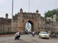
Jatpura gate of Chandrapur Fort
-
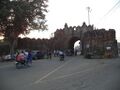
Anchaleshwar gate of Chandrapur Fort
-
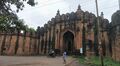
Pathanpura gate of Chandrapur Fort


Manikgarh Fort: Manikgarh Fort was built by Tribal Naga Kings during 9th century. Manikgarh, made famous by a newly established cement factory near by, is about 35kms south-west of Chandrapur. Built by tribal Naga kings in the 9th century, the Manigarh hill fort stands at the height of 507 metres above sea-level. It was strongly fortified with walls and bastions. Today, the fort is in complete ruins and has become a sanctuary for wild animals. A pukka road through a dense forest leads very close to the gateway of the fort. Nearby is an old temple of Vishnu. The fort is now in ruined condition and only remnants are damaged structures, tanks, walls and bastions. Its ruined walls and bastions show the signs of strong fortifications of that time.[19]
Ballalpur Fort: Ballalpur Fort is located in Ballalpur town with 16 km from Chandrapur. Khandakya Ballalshah built this land fort on the eastern bank of the Wardha River. The fort is square in shape with walls and bastions. The fort walls are still intact, but all the old structures are in total ruins. There are still two intact gates set at right angle to each other and small postern gate on the river side.[20]
Mahakali Mandir: Mahakali Mandir (temple) is an often frequented temple in Chandrapur. The ancient temple was built by Dhundya Ram Sah, of Gond Dynasty around the 16th century. Tuesdays are a particularly significant day to visit. Within the mandir there is a small Ganesh temple and a Hanuman temple. At the two temple entrances, there are small shops for puja (worship) supplies such as coconut, flowers and cloth. Items for home décor and puja décor are sold near the temple. Near the rear entrance there is a Shani temple.
Within the temple are two murtis (idols). One associated with ShivaLinga is a standing idol decorated with red, yellow and orange cloths. The other is in a reclining position below the ground level, and devotees must walk in a tunnel to reach it. Inside the temple, a priest is present to assist visitors with puja and offerings. A trust administers the temple. Dharmashalas provide accommodation for pilgrims. The annual yatra (fair) takes place in April, entertaining the followers of Mahakali and the citizens of Chandrapur.[21]
Anchaleshwar Mandir: The Anchaleshwar Mandir celebrates a form of the Lord Shiva. It is situated adjoining Anchaleshwar Gate of Chandrapur fort on the banks of the Zarpat river. The official samadhi (mausoleum) of the Gond kings is located within the temple complex.[22]
Tadoba Andhari Tiger Reserve: The Tadoba Andhari Tiger Reserve is located approximately 30 km north of Chandrapur near the Erai dam. This park was included in the project tiger since 1973. The total area of the reserve is 625.40 km2. In 2014 the tiger population in Tadoba was 66, that number has gone up to 86. Tadoba is now a home to 86 Tigers despite years of lynching, poaching & other threats. There are many hotels and resorts near Moharli gate, Zari gate and Navegaon gate of the reserve, available for the tourists. The guided tours inside the park are available during early morning and evening time only.[23]
Vijasan Hills: There are several temples here which are very attractive. The atmosphere here is very serene and calm and one can come here to soak in the religious significance of the place as well as to relax in the serenity of the environment.[24]
Junona Lake: This spot is 15 kms away from the town of Chandrapur. Here, there are well developed facilities for boating, and there are also restaurants and parks located here.
Ghora Jhari Lake: This lake is situated in Nagbhir tehsil. It is 6 kms away from the main Nagpur – Chandrapur highway, 106 kms from Chandrapur town and 97 kms from Nagpur. The capacity of the reservoir is 45 cusecs of water.[25]
Bhadravati Jain Temple: This temple in the town is very popular with the Jain community. It has very beautiful sculptures. This temple is located as Bhadravati village, 32 km from Chandrapur town on Central Railways. This temple is said to be extremely old, but the exact time of its construction is not known. There are several other idols in the temples, which were recovered in digging the earth
Anandvan Ashram, Warora: Warora town has come into prominence due to location of the “Anandvan Ashram”. Maharogi Seva Samiti, which also handles the Lok Biradari Prakalp and the Somnath Project, runs and manages this centre. Well known Social worker and Maharashtrabhushan Shri Baba Amte whose services and efforts for the rehabilitation and care of leprosy patients have earned him worldwide recognition. Foreign tourists in large numbers often visit Anandvan Ashram.[26]
The Anandvan Ashram, located in the town of Warora, is just few kilometres from Chandrapur city. It was founded in 1951 by a social activist named Baba Amte. Essentially an ashram, this centre mostly serves as a community rehabilitation centre for patients suffering from leprosy. It also serves the disabled, from downtrodden sections of society.[27]
In the ashram, there are numerous small-scale and home-based industry units. These are run by the residents for generating income, which can cover additional requirements of the ashram.[28]
Chandrapur Super Thermal Power Station (CSTPS): Chandrapur Super Thermal Power Station (CSTPS) is the largest thermal power station of the Maharashtra State Electricity Board. Located just 6 km from the city, this thermal power station lies on the main route to Tadoba National Park. The power station has a capacity of over 2340 MW. A dam on Erai River has also been constructed at a distance of 15 km from this thermal power station. 420 m long, this dam caters to the water requirements of the thermal power station. The effective water storage capacity of this dam is around 198 million cubic metres. Around 12 million cubic metres is released annually to the Chandrapur city.[29]
Visit by Xuanzang in 639 AD
Alexander Cunningham[30] writes that From Kalinga the Chinese pilgrim Xuanzang proceeded about 1800 or 1900 li, or from 300 to 317 miles,[31] to the
[p.520]: north-west to the kingdom of Kiao-sa-lo, or Kosala. The bearing and distance take us to the ancient province of Vidarbha, or Berar, of which the present capital is Nagpur. This agrees exactly with the position of Kosala as described in the Ratnavali, and in the Vishnu Purana.[32] In the former, the king of Kosala is surrounded in the Vindhyan mountains, and in the latter it is stated that Kusa the son of Rama, ruled over Kosala, at his capital of Kusasthali, or Kusavati, built upon the Vindhyan precipices.
All these concurring data enable us to identify the ancient Kosala with the modern province of Berar, or Gondwana. The position of the capital is more difficult to fix, as Hwen Thsang does not mention its name ; but as it was 40 li, or nearly 7 miles, in circuit, it is most probably represented by one of the larger cities of the present day. These are Chanda, Nagpur, Amaravati, and Elichpur.
Chanda is a walled town, 6 miles in circuit, with a citadel. It is situated just below the junction of the Pain Ganga and Warda Rivers, at a distance of 290 miles to the north-west of Rajamahendri, on the Godavari, and of 280 miles from Dharanikota, on the Kistna. Its position, therefore, corresponds almost exactly with the bearing and distance of Hwen Thsang.
Nagpur is a large straggling town, about 7 miles in circuit ; but as it is 85 miles to the north of Chanda, its distance from Rajamahendri is about 70 miles in excess of the number stated by the Chinese pilgrim.
Amaravati is about the same distance from
[p.521]: Rajamahendri, and Elichpur is 30 miles still further to the north. Chanda is therefore the only place of consequence that has a strong claim to be identified with the capital of Kosala in the seventh century. The recorded distance of 1800 or 1900 li from Rajamahendri is further supported by the subsequent distance of 1900 li, or 900 plus 1000 li, to Dhanakakata, which was almost certainly the same place as Dharanikota, or Amaravati, on the Kistna river. Now, the road distance of Chanda from Dharanikota is 280 miles, or 1680 li, by the direct route; but as Hwen Thsang first proceeded for 900li to the south-west, and then for 1000 li to the south, the direct distance between the two places would not have been more than 1700 li.
चंद्रपुर
1. Chandrapura (चंद्रपुर) = Chanderi (चंदेरी), म.प्र.,
2. Chandrapura (चंद्रपुर) = Chandrapuri (चंद्रपुरी) (जिला बनारस, उ.प्र.),
3. Chandrapura (चंद्रपुर) = Chanda (चांदा), महा., (AS, p.318) - महाराष्ट्र में स्थित वर्तमान चांदा जहाँ कनिंघम के अनुसार सातवीं शती में दक्षिण कोसल की राजधानी थी. (एन्सिएंट ज्योग्राफी ऑफ इंडिया,पृ.596)[33]
चंद्रपुर परिचय
चन्द्रपुर (भूतपूर्व चंदा) शहर, पूर्वी महाराष्ट्र राज्य, पश्चिम भारत में वर्धा नदी की एक सहायक नदी के तट पर स्थित है। चंद्रपुर का अर्थ है, 'चंद्रमा का घर'। 9वीं से 18वीं शताब्दी तक चंद्रपुर गोंड वंश की राजधानी था। बाद में नागपुर के मराठा भोंसले ने इसे जीत लिया। 1854 से 1947 में भारत के स्वतंत्र होने तक यह ब्रिटिश मध्य प्रांत का हिस्सा था। यह ब्रिटिश शासन के दौरान चांद नाम से जाना जाता था। इस स्थान का प्राचीन नाम लोकपुरा भी था, जो आगे चलकर इन्दूर और उसके बाद चन्द्रपुर के नाम से जाना गया। इस ज़िले के प्राचीन स्थल वैरंगढ, कोसल, भद्रावती और मरकड हैं। चन्द्रपुर पर काफ़ी लंबे समय तक हिन्दू और बौद्ध राजाओं का शासन रहा है। बाद में गोंड राजाओं ने इस पर अधिकार कर लिया जिन्होंने 1751 तक यहाँ शासन किया। बाद में इसे ब्रिटिश शासन में मिला लिया गया।
यातायात और परिवहन : वायु मार्ग - चन्द्रपुर का नज़दीकी हवाई अड्डा नागपुर में डॉ. बाबा साहेब अम्बेडकर हवाई अड्डा है जो देश के अनेक शहरों से वायु मार्ग द्वारा जुड़ा हुआ है।
रेल मार्ग: मुंबई वर्धा चन्द्रपुर रेल लाइन से महाराष्ट्र का यह ज़िला जुड़ा है। महाराष्ट्र और पड़ोसी राज्यों के अनेक शहरों से यहाँ के लिए नियमित रेलगाड़ियाँ हैं।
सड़क मार्ग: मुंबई नासिक चन्द्रपुर सड़क मार्ग चन्द्रपुर को महाराष्ट्र और देश के अन्य शहरों से जोड़ता है। राज्य परिवहन के अलावा अनेक निजी बसें चन्द्रपुर के लिए चलती हैं।
पर्यटन: पर्यटकों के देखने लायक़ यहाँ अनेक ऐतिहासिक मन्दिर और स्मारक हैं। साथ ही यहाँ के वन्यजीव अभ्यारण्य भी यहाँ आने वाले सैलानियों के आकर्षण का केंद्र होते हैं। चंद्रपुर के उत्तर में ताडोबा राष्ट्रीय उद्यान स्थित है। इसके 45 किमी दक्षिण में मानिकगढ़ वन पर्यावरण सैरगाह है। यहाँ कई प्रकार के बांस व दूसरे वृक्ष, बाघ, तेंदुआ, जंगली कुत्ते, भालू गौर, सांबर, मुंतजाक हिरन जैसे जानवर व अनेक प्रजातियों के जंगली पक्षी पाए जाते हैं।
संदर्भ: भारतकोश-चन्द्रपुर
Jat Gotras in Chandrapur
Notable Jats
- Mahipal Dharmpal Chhonkare - Engineer. Presently X.En. in Maharashtra Vidyut Vitran Nigam, Bhusawal, Maharashtra. Social worker. Ex. President Akhil Bharatiy Jat Mahasabha Chandrapur. Phone Nagpur:440022, Mob - 9423416554, 989073211. Email: mdsingh55@gmail.com
External links
References
- ↑ https://www.britannica.com/place/Chandrapur
- ↑ Deogaonkar, Shashishekhar (2007). The Gonds of Vidarbha. Concept Publishing Company, 2007. p. 37. ISBN 978-8180694745.
- ↑ Corpus Inscriptionum Indicarum Vol.5 (Inscriptions of The Vakatakas), Edited by Vasudev Vishnu Mirashi, 1963, Archaeological Survey of India, p.42-47
- ↑ Hussain. Geography of India for Civil Ser Exam. Tata McGraw-Hill Education. ISBN 9780070667723.
- ↑ https://www.indianetzone.com/geography_chandrapur_district
- ↑ Corpus Inscriptionum Indicarum Vol.5 (inscriptions Of The Vakatakas), Edited by Vasudev Vishnu Mirashi, 1963, Archaeological Survey of India, p.1-4
- ↑ Miksic, John (2003). Earthenware in Southeast Asia: Proceedings of the Singapore Symposium. NUS Press. ISBN 9971692716.
- ↑ Meyer, William (1966). Chandragupta Maurya and his times. Motilal Banarsidass. ISBN 9788120804050.
- ↑ Thapar, Romila (2004). Early India. Los Angeles: University of California press. p. 2010. ISBN 9780520242258.
- ↑ Dutt, Sukumar (1988). Buddhist Monks and Monasteries. Motilal Banarsidass. p. 123. ISBN 9788120804982.
- ↑ Majumdar R.C. Vakataka – Gupta Age Circa 200-550 A.D. Motilal Banarsidass 1986. p. 123
- ↑ Mirashi, V. V.; Navlekar, N. R. (1969). Kalidasa: Date, Life And Works. Popular Prakashan. p. 22. ISBN 9788171544684.
- ↑ Ramesh, K. V. (1984). Chalukyas of Vatapi. Agam Kala Prakashan.
- ↑ Sen, S. N. (1999). Ancient Indian History and Civilisation. New Age International. p. 403. ISBN 9788122411980.
- ↑ "Kingdoms of South Asia". The History Files.
- ↑ Strong, Rowan (2002). Episcopalianism in Nineteenth-Century Scotland. Oxford: Oxford University Press. p. 31. ISBN 9780199249220.
- ↑ Corpus Inscriptionum Indicarum Vol.5 (Inscriptions of The Vakatakas), Edited by Vasudev Vishnu Mirashi, 1963, Archaeological Survey of India, p.42-47
- ↑ Government of Maharashtra. "Places of Interest". chanda.nic.in. Government of Maharashtra.
- ↑ Government of Maharashtra. "Places of Interest". chanda.nic.in. Government of Maharashtra.
- ↑ Government of Maharashtra. "Places of Interest". chanda.nic.in. Government of Maharashtra.
- ↑ Government of Maharashtra. "Places of Interest". chanda.nic.in. Government of Maharashtra.
- ↑ Government of Maharashtra. "Places of Interest". chanda.nic.in. Government of Maharashtra.
- ↑ Government of Maharashtra. "Places of Interest". chanda.nic.in. Government of Maharashtra.
- ↑ Government of Maharashtra. "Places of Interest". chanda.nic.in. Government of Maharashtra.
- ↑ Government of Maharashtra. "Places of Interest". chanda.nic.in. Government of Maharashtra.
- ↑ Government of Maharashtra. "Places of Interest". chanda.nic.in. Government of Maharashtra.
- ↑ Government of Maharashtra. "Places of Interest". chanda.nic.in. Government of Maharashtra.
- ↑ Government of Maharashtra. "Places of Interest". chanda.nic.in. Government of Maharashtra.
- ↑ Government of Maharashtra. "Places of Interest". chanda.nic.in. Government of Maharashtra.
- ↑ The Ancient Geography of India: I. The Buddhist Period, Including the Campaigns of Alexander, and the Travels of Hwen-Thsang. By Sir Alexander Cunningham, p.519-526
- ↑ Julien's ' Hiouen Thsang,' vol. i. p. 185, gives 1800 li, and vol. iii. p. 94, 1900 U. See Map No. I.
- ↑ H. H. Wilson, 'Vishnu Purana,' Hall's edition, ii. 172, note.
- ↑ Aitihasik Sthanavali by Vijayendra Kumar Mathur, p.318
Back to Maharashtra